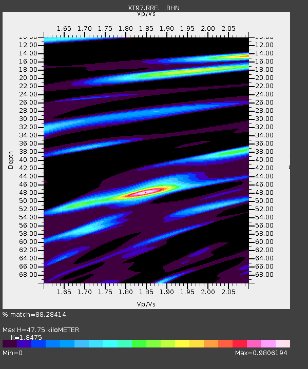
RRE XT.RRE - Earthquake Result Viewer

Earthquake location: Near East Coast Of Kamchatka
Earthquake latitude/longitude: 54.7/162.9
Earthquake time(UTC): 1997/12/07 (341) 17:56:18 GMT
Earthquake Depth: 33 km
Earthquake Magnitude: 5.6 MB, 6.0 MS, 6.3 UNKNOWN, 6.1 MW
Earthquake Catalog/Contributor: WHDF/NEIC
Network: XT Colorado BB Array - Lodore
Station: RRE XT.RRE
Lat/Lon: 41.17 N/108.73 W
Elevation: 2353 m
Distance: 56.9 deg
Az: 64.268 deg
Baz: 316.107 deg
Ray Param: 0.063778795
Estimated Moho Depth: 47.75 km
Estimated Crust Vp/Vs: 1.85
Assumed Crust Vp: 6.207 km/s
Estimated Crust Vs: 3.36 km/s
Estimated Crust Poisson's Ratio: 0.29
Radial Match: 88.28414 %
Radial Bump: 392
Transverse Match: 79.29543 %
Transverse Bump: 400
SOD ConfigId: 4480
Insert Time: 2010-03-09 01:43:36.285 +0000
GWidth: 2.5
Max Bumps: 400
Tol: 0.001

Signal To Noise

ChannelStoNSTALTA
XT:RRE: :BHN:19971207T18:05:29.725024Z2.02387335.4972344E-72.7161948E-7
XT:RRE: :BHE:19971207T18:05:29.725024Z0.742634242.2062743E-72.970876E-7
XT:RRE: :BHZ:19971207T18:05:29.725024Z0.49743171.0455016E-72.1017993E-7
Arrivals
Ps6.8 SECOND
PpPs21 SECOND
PsPs/PpSs28 SECOND