
Station XT RRE - XT.RRE
Network: XT97 - Colorado BB Array - Lodore
Nearby stations (2 deg radius)

| Station | Name | (Lat, Lon) | Start / End | Elevation |
| RRE | XT.RRE | (41.17, -108.73) | 1997-08-01 / 1998-07-15 | 2353 m |
| Crust2 Type: | Q4,orogen/43km no ice, Tethian Belt, 5 km seds. |
| Thickness Estimate: | 66 km |
| Thickness StdDev: | 15 km |
| Vp/Vs Estimate: | 1.60 |
| Vp/Vs StdDev: | 0.15 |
| Vs Estimate: | 3.879 km/s |
| Poisson's Ratio: | 0.18 |
| Peak Value: | 0.02 |
| Assumed Vp: | 6.207 km/s |
| Ps Weight: | 0.33333334 |
| PpPs Weight: | 0.33333334 |
| PsPs Weight: | 0.33333328 |
| Residual Complexity: | 0.871 |
| Nearby stations H: | +- |
| (2.0 deg) Vp/Vs: | +- |
9 with match > 90% ( 23.68421 %) and 17 with match > 80% ( 44.736843 %) out of 38.
Download stack as xyz text file.
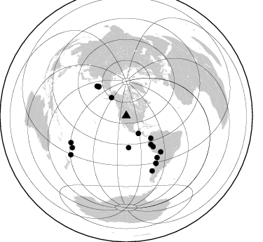
Azimuth Distribution of Events:
Prior Results for this Station
| Study | Thickness | Vp/Vs | Vp | Vs | Poissons Ratio | Extra |
| EARS | 66 km | 1.60 | 6.207 km/s | 3.879 km/s | 0.18 | |
| Crust2.0 | 43 km | 1.76 | 6.207 km/s | 3.535 km/s | 0.26 | Q4,orogen/43km no ice, Tethian Belt, 5 km seds. |
| Global Maxima | 66 km | 1.60 | 6.207 km/s | 3.879 km/s | 0.18 | amp=0.017891902 |
| Local Maxima 1 | 47 km | 1.87 | 6.207 km/s | 3.315 km/s | 0.30 | amp=0.01575374 |
| Local Maxima 2 | 32 km | 1.60 | 6.207 km/s | 3.879 km/s | 0.18 | amp=0.015725767 |
| Local Maxima 3 | 29 km | 1.60 | 6.207 km/s | 3.879 km/s | 0.18 | amp=0.011217221 |
| Local Maxima 4 | 49 km | 1.81 | 6.207 km/s | 3.429 km/s | 0.28 | amp=0.005808354 |
| Predicted Arrivals for vertical incidence (zero ray parameter) | |
| Ps | 6.38 SECOND |
| PpPs | 27.65 SECOND |
| PsPs/PpSs | 34.03 SECOND |
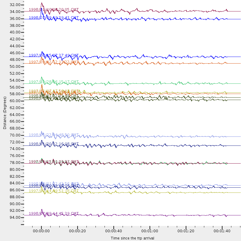
Events Processed for this Station
Download zip of receiver functions as SAC
Plot maxima for each earthquake.
Events Used in the Stack
(17 events)| Radial Match | Distance | Baz | FERegion | Time | Lat/Lon | Depth | Magnitude |
| 96.65604 | 57.3 deg | 316.56 deg | Near East Coast Of Kamchatka | 1997/12/05 11:26:54 GMT | (54.8, 162.0) | 33 km | 6.3 MB, 7.6 MS, 7.9 UNKNOWN, 7.3 ME |
| 95.167145 | 89.1 deg | 239.342 deg | South Of Fiji Islands | 1997/10/14 09:53:18 GMT | (-22.1, -176.8) | 167 km | 6.7 MB, 7.7 UNKNOWN, 7.4 ME |
| 93.71599 | 86.7 deg | 154.742 deg | Off Coast Of Southern Chile | 1998/04/01 22:42:56 GMT | (-40.3, -74.9) | 9.0 km | 6.2 MB, 6.0 MS, 6.7 UNKNOWN, 6.6 ME |
| 92.38817 | 74.0 deg | 143.623 deg | Near Coast Of Northern Chile | 1998/01/30 12:16:08 GMT | (-23.9, -70.2) | 42 km | 6.3 MB, 6.5 MS, 7.0 UNKNOWN, 6.7 ME |
| 91.90007 | 54.0 deg | 139.121 deg | Northern Peru | 1997/10/28 06:15:17 GMT | (-4.4, -76.7) | 112 km | 6.6 MB, 6.3 MS, 7.2 UNKNOWN, 6.6 ME |
| 91.57186 | 33.2 deg | 320.801 deg | Southern Alaska | 1998/07/09 19:39:43 GMT | (60.5, -153.2) | 145 km | 5.3 MB, 6.2 UNKNOWN, 6.2 MW |
| 90.50084 | 59.2 deg | 315.146 deg | Off East Coast Of Kamchatka | 1998/06/01 05:34:03 GMT | (52.9, 160.1) | 44 km | 6.2 MB, 6.3 MS, 6.5 UNKNOWN, 6.4 MW |
| 90.43416 | 79.7 deg | 147.869 deg | Near Coast Of Central Chile | 1997/10/15 01:03:33 GMT | (-30.9, -71.2) | 58 km | 6.8 MB, 6.8 MS, 7.3 UNKNOWN, 7.1 MW |
| 90.19126 | 45.4 deg | 175.749 deg | Central East Pacific Rise | 1997/08/15 07:37:49 GMT | (-4.4, -105.7) | 10 km | 5.3 MB, 5.8 MS, 6.2 UNKNOWN, 6.1 MW |
| 88.645584 | 71.0 deg | 136.273 deg | Central Bolivia | 1998/05/22 04:48:50 GMT | (-17.7, -65.4) | 24 km | 5.9 MB, 6.6 MS, 6.6 UNKNOWN, 6.2 ME |
| 88.593636 | 30.6 deg | 145.646 deg | Guatemala | 1998/01/10 08:20:05 GMT | (14.4, -91.5) | 33 km | 6.1 MB, 6.2 MS, 6.6 UNKNOWN, 6.6 ME |
| 88.28414 | 56.9 deg | 316.107 deg | Near East Coast Of Kamchatka | 1997/12/07 17:56:18 GMT | (54.7, 162.9) | 33 km | 5.6 MB, 6.0 MS, 6.3 UNKNOWN, 6.1 MW |
| 86.699844 | 87.4 deg | 244.086 deg | Fiji Islands Region | 1998/03/29 19:48:16 GMT | (-17.6, -179.1) | 537 km | 6.5 MB, 7.2 UNKNOWN, 7.1 MW |
| 86.350365 | 79.6 deg | 148.041 deg | Near Coast Of Central Chile | 1998/01/12 10:14:07 GMT | (-31.0, -71.4) | 35 km | 5.8 MB, 6.2 MS, 6.6 UNKNOWN, 6.2 ME |
| 85.88788 | 47.5 deg | 132.545 deg | Colombia | 1997/09/02 12:13:22 GMT | (3.8, -75.7) | 199 km | 6.5 MB, 6.8 UNKNOWN, 6.4 ME |
| 80.74082 | 58.4 deg | 138.841 deg | Peru-Brazil Border Region | 1998/04/03 22:01:48 GMT | (-8.1, -74.2) | 165 km | 6.1 MB, 5.6 MS, 6.6 UNKNOWN, 6.6 MW |
| 80.71004 | 96.4 deg | 234.841 deg | Kermadec Islands, New Zealand | 1998/07/09 14:45:39 GMT | (-30.5, -179.0) | 130 km | 6.2 MB, 6.2 MS, 6.9 UNKNOWN, 6.4 ME |
Losers
(21 events)| Radial Match | Distance | Baz | FERegion | Time | Lat/Lon | Depth | Magnitude | Reason |
| 77.23412 | 79.6 deg | 310.224 deg | Near East Coast Of Honshu, Japan | 1998/04/09 08:45:40 GMT | (36.9, 140.8) | 111 km | 5.6 UNKNOWN, 5.3 MB, 5.5 MW | |
| 76.84243 | 94.3 deg | 235.281 deg | Kermadec Islands Region | 1997/09/20 16:11:32 GMT | (-28.7, -177.6) | 30 km | 6.1 MB, 7.0 MS, 7.2 UNKNOWN, 6.7 ME | |
| 76.70534 | 49.2 deg | 307.596 deg | Rat Islands, Aleutian Islands | 1997/12/17 04:38:51 GMT | (51.2, 178.9) | 20 km | 5.8 MB, 6.5 MS, 6.7 UNKNOWN, 6.1 ME | |
| 73.87478 | 30.6 deg | 145.629 deg | Guatemala | 1998/03/03 02:24:43 GMT | (14.4, -91.5) | 63 km | 5.5 MB, 5.4 MS, 6.2 UNKNOWN, 6.1 MW | |
| 73.0094 | 30.5 deg | 147.224 deg | Near Coast Of Chiapas, Mexico | 1997/12/25 22:16:19 GMT | (14.1, -92.3) | 10 km | 5.4 MB, 5.3 MS, 5.8 UNKNOWN, 5.5 MD | |
| 72.74853 | 89.0 deg | 37.894 deg | Ionian Sea | 1997/11/18 13:07:41 GMT | (37.6, 20.7) | 33 km | 5.9 MB, 6.4 MS, 6.7 UNKNOWN, 6.1 ML | |
| 72.43621 | 65.9 deg | 136.901 deg | Peru-Bolivia Border Region | 1997/11/28 22:53:41 GMT | (-13.7, -68.8) | 586 km | 6.4 MB, 6.6 UNKNOWN, 6.6 MW | |
| 70.98851 | 31.6 deg | 145.017 deg | Near Coast Of Guatemala | 1998/05/10 06:05:58 GMT | (13.7, -90.7) | 33 km | 5.3 MB, 5.9 MS, 6.3 UNKNOWN, 5.3 MD | |
| 70.42702 | 92.7 deg | 291.322 deg | Mariana Islands | 1998/05/15 05:58:06 GMT | (14.2, 144.9) | 154 km | 5.7 MB, 6.0 UNKNOWN, 6.0 MW | |
| 69.32084 | 85.0 deg | 40.342 deg | Southern Italy | 1998/05/18 17:19:04 GMT | (39.3, 15.1) | 280 km | 5.6 MB | |
| 68.60483 | 60.8 deg | 140.651 deg | Central Peru | 1998/02/19 04:21:30 GMT | (-11.0, -74.4) | 33 km | 5.8 MB, 5.4 MS, 6.0 UNKNOWN, 5.9 MW | |
| 67.44967 | 90.9 deg | 241.055 deg | South Of Fiji Islands | 1998/05/16 02:22:03 GMT | (-22.2, -179.5) | 586 km | 6.1 MB, 6.8 UNKNOWN | |
| 65.06109 | 47.4 deg | 132.527 deg | Colombia | 1997/12/11 07:56:28 GMT | (3.9, -75.8) | 178 km | 6.0 MB, 6.4 UNKNOWN, 6.3 MW | |
| 61.159504 | 32.3 deg | 141.607 deg | El Salvador | 1997/12/18 15:02:00 GMT | (13.8, -88.7) | 182 km | 5.3 MB, 6.1 UNKNOWN, 6.0 MW | |
| 59.33003 | 97.0 deg | 311.918 deg | Southwestern Ryukyu Isl., Japan | 1997/08/13 04:45:04 GMT | (25.0, 125.8) | 55 km | 6.0 MB, 5.6 MS, 6.1 UNKNOWN, 6.1 MW | |
| 59.232094 | 95.4 deg | 239.305 deg | South Of Fiji Islands | 1997/09/04 04:23:37 GMT | (-26.6, 178.3) | 625 km | 6.3 MB, 6.8 UNKNOWN, 6.5 ME | |
| 58.36473 | 89.9 deg | 241.698 deg | Fiji Islands Region | 1997/11/04 10:40:43 GMT | (-21.0, -179.2) | 621 km | 5.7 UNKNOWN, 5.1 MB | |
| 54.843285 | 88.8 deg | 240.918 deg | Fiji Islands Region | 1997/08/25 11:59:00 GMT | (-20.8, -177.8) | 394 km | 5.5 UNKNOWN, 5.3 MB | |
| 52.45271 | 81.6 deg | 145.581 deg | San Juan Province, Argentina | 1998/06/07 16:10:46 GMT | (-31.5, -67.8) | 113 km | 5.6 MB, 5.9 UNKNOWN, 5.9 MW | |
| 50.814297 | 80.8 deg | 309.273 deg | Near East Coast Of Honshu, Japan | 1998/06/14 13:17:08 GMT | (35.4, 140.5) | 45 km | 5.5 MB, 5.3 MS, 5.8 UNKNOWN, 5.8 MW | |
| 48.68403 | 96.9 deg | 233.459 deg | Kermadec Islands Region | 1997/10/07 13:15:53 GMT | (-31.8, -178.3) | 33 km | 5.5 MB, 5.6 MS |
