You are here: Home > Network List > XT97 - Colorado BB Array - Lodore Stations List
> Station RRW XT.RRW > Earthquake Result Viewer
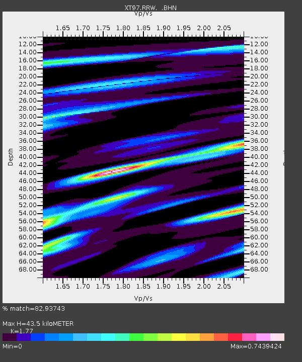
RRW XT.RRW - Earthquake Result Viewer
| Earthquake location: |
Kermadec Islands Region |
| Earthquake latitude/longitude: |
-28.7/-177.6 |
| Earthquake time(UTC): |
1997/09/20 (263) 16:11:32 GMT |
| Earthquake Depth: |
30 km |
| Earthquake Magnitude: |
6.1 MB, 7.0 MS, 7.2 UNKNOWN, 6.7 ME |
| Earthquake Catalog/Contributor: |
WHDF/NEIC |
|
| Network: |
XT Colorado BB Array - Lodore |
| Station: |
RRW XT.RRW |
| Lat/Lon: |
41.14 N/108.86 W |
| Elevation: |
2320 m |
|
| Distance: |
94.2 deg |
| Az: |
44.901 deg |
| Baz: |
235.2 deg |
| Ray Param: |
0.041097153 |
| Estimated Moho Depth: |
43.5 km |
| Estimated Crust Vp/Vs: |
1.77 |
| Assumed Crust Vp: |
6.207 km/s |
| Estimated Crust Vs: |
3.507 km/s |
| Estimated Crust Poisson's Ratio: |
0.27 |
|
| Radial Match: |
82.93743 % |
| Radial Bump: |
400 |
| Transverse Match: |
76.60446 % |
| Transverse Bump: |
400 |
| SOD ConfigId: |
6273 |
| Insert Time: |
2010-03-09 01:44:01.575 +0000 |
| GWidth: |
2.5 |
| Max Bumps: |
400 |
| Tol: |
0.001 |
|

Signal To Noise
| Channel | StoN | STA | LTA |
| XT:RRW: :BHN:19970920T16:24:16.475Z | 1.5207684 | 2.909186E-7 | 1.912971E-7 |
| XT:RRW: :BHE:19970920T16:24:16.475Z | 1.7639015 | 3.9561664E-7 | 2.2428499E-7 |
| XT:RRW: :BHZ:19970920T16:24:16.475Z | 6.2122917 | 1.0992793E-6 | 1.7695228E-7 |
| Arrivals |
| Ps | 5.5 SECOND |
| PpPs | 19 SECOND |
| PsPs/PpSs | 25 SECOND |


