
Station XT RRW - XT.RRW
Network: XT97 - Colorado BB Array - Lodore
Nearby stations (2 deg radius)
| Station | Name | (Lat, Lon) | Start / End | Elevation |
| RRW | XT.RRW | (41.14, -108.86) | 1997-08-01 / 1998-07-15 | 2320 m |
| Crust2 Type: | Q4,orogen/43km no ice, Tethian Belt, 5 km seds. |
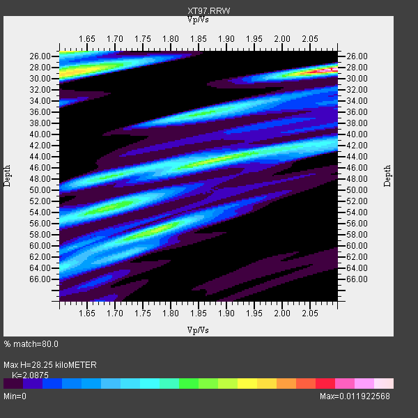
| Thickness Estimate: | 28 km |
| Thickness StdDev: | 10 km |
| Vp/Vs Estimate: | 2.09 |
| Vp/Vs StdDev: | 0.21 |
| Vs Estimate: | 2.973 km/s |
| Poisson's Ratio: | 0.35 |
| Peak Value: | 0.01 |
| Assumed Vp: | 6.207 km/s |
| Ps Weight: | 0.33333334 |
| PpPs Weight: | 0.33333334 |
| PsPs Weight: | 0.33333328 |
| Residual Complexity: | 0.898 |
| Nearby stations H: | +- |
| (2.0 deg) Vp/Vs: | +- |
8 with match > 90% ( 17.777779 %) and 13 with match > 80% ( 28.88889 %) out of 45.
Download stack as xyz text file.
Azimuth Distribution of Events:

Prior Results for this Station
| Study | Thickness | Vp/Vs | Vp | Vs | Poissons Ratio | Extra |
| EARS | 28 km | 2.09 | 6.207 km/s | 2.973 km/s | 0.35 | |
| Crust2.0 | 43 km | 1.76 | 6.207 km/s | 3.535 km/s | 0.26 | Q4,orogen/43km no ice, Tethian Belt, 5 km seds. |
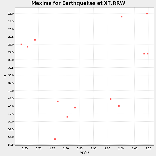
| Global Maxima | 28 km | 2.09 | 6.207 km/s | 2.973 km/s | 0.35 | amp=0.011922568 |
| Local Maxima 1 | 29 km | 1.62 | 6.207 km/s | 3.82 km/s | 0.20 | amp=0.008102295 |
| Local Maxima 2 | 25 km | 1.61 | 6.207 km/s | 3.861 km/s | 0.18 | amp=0.0076788086 |
| Local Maxima 3 | 44 km | 1.88 | 6.207 km/s | 3.31 km/s | 0.30 | amp=0.0069640228 |
| Local Maxima 4 | 57 km | 1.78 | 6.207 km/s | 3.492 km/s | 0.27 | amp=0.0069023934 |
| Predicted Arrivals for vertical incidence (zero ray parameter) | |
| Ps | 4.95 SECOND |
| PpPs | 14.05 SECOND |
| PsPs/PpSs | 19.00 SECOND |
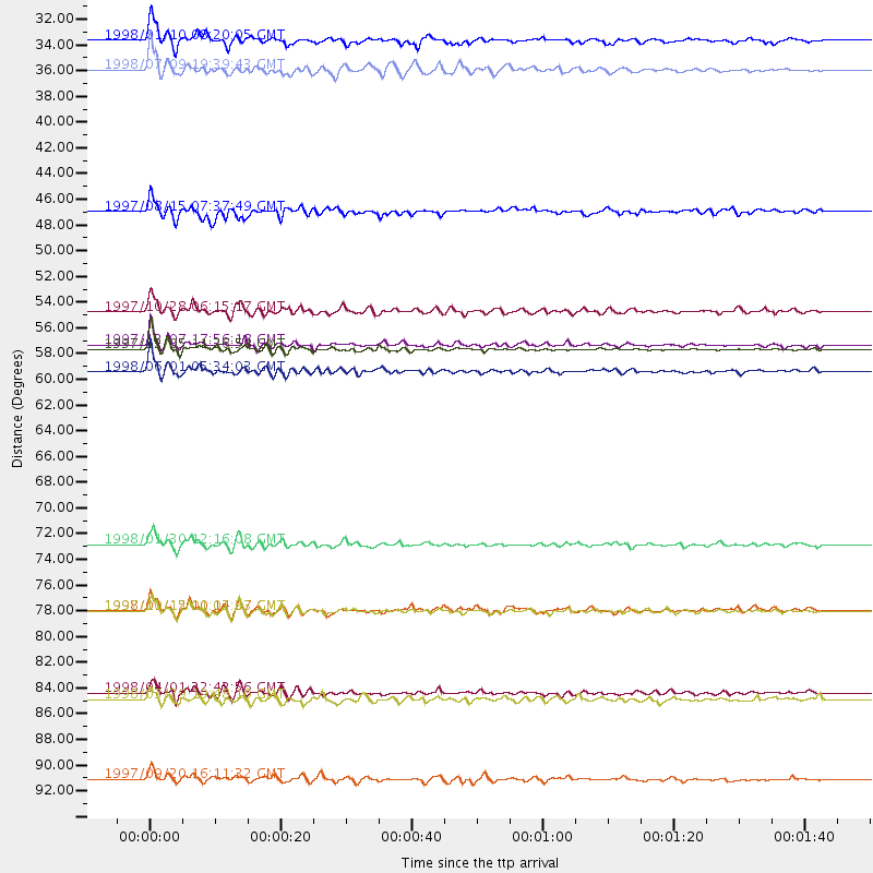
Events Processed for this Station
Download zip of receiver functions as SAC
Plot maxima for each earthquake.
Events Used in the Stack
(13 events)| Radial Match | Distance | Baz | FERegion | Time | Lat/Lon | Depth | Magnitude |
| 98.020584 | 57.2 deg | 316.535 deg | Near East Coast Of Kamchatka | 1997/12/05 11:26:54 GMT | (54.8, 162.0) | 33 km | 6.3 MB, 7.6 MS, 7.9 UNKNOWN, 7.3 ME |
| 95.48066 | 79.7 deg | 147.769 deg | Near Coast Of Central Chile | 1997/10/15 01:03:33 GMT | (-30.9, -71.2) | 58 km | 6.8 MB, 6.8 MS, 7.3 UNKNOWN, 7.1 MW |
| 92.266365 | 33.2 deg | 320.86 deg | Southern Alaska | 1998/07/09 19:39:43 GMT | (60.5, -153.2) | 145 km | 5.3 MB, 6.2 UNKNOWN, 6.2 MW |
| 91.31835 | 56.9 deg | 316.083 deg | Near East Coast Of Kamchatka | 1997/12/07 17:56:18 GMT | (54.7, 162.9) | 33 km | 5.6 MB, 6.0 MS, 6.3 UNKNOWN, 6.1 MW |
| 91.25354 | 74.0 deg | 143.513 deg | Near Coast Of Northern Chile | 1998/01/30 12:16:08 GMT | (-23.9, -70.2) | 42 km | 6.3 MB, 6.5 MS, 7.0 UNKNOWN, 6.7 ME |
| 90.96654 | 59.2 deg | 315.116 deg | Off East Coast Of Kamchatka | 1998/06/01 05:34:03 GMT | (52.9, 160.1) | 44 km | 6.2 MB, 6.3 MS, 6.5 UNKNOWN, 6.4 MW |
| 90.66329 | 86.8 deg | 154.654 deg | Off Coast Of Southern Chile | 1998/04/01 22:42:56 GMT | (-40.3, -74.9) | 9.0 km | 6.2 MB, 6.0 MS, 6.7 UNKNOWN, 6.6 ME |
| 90.00399 | 54.0 deg | 138.972 deg | Northern Peru | 1997/10/28 06:15:17 GMT | (-4.4, -76.7) | 112 km | 6.6 MB, 6.3 MS, 7.2 UNKNOWN, 6.6 ME |
| 86.81471 | 30.7 deg | 145.402 deg | Guatemala | 1998/01/10 08:20:05 GMT | (14.4, -91.5) | 33 km | 6.1 MB, 6.2 MS, 6.6 UNKNOWN, 6.6 ME |
| 86.08663 | 45.4 deg | 175.57 deg | Central East Pacific Rise | 1997/08/15 07:37:49 GMT | (-4.4, -105.7) | 10 km | 5.3 MB, 5.8 MS, 6.2 UNKNOWN, 6.1 MW |
| 85.32485 | 79.7 deg | 147.94 deg | Near Coast Of Central Chile | 1998/01/12 10:14:07 GMT | (-31.0, -71.4) | 35 km | 5.8 MB, 6.2 MS, 6.6 UNKNOWN, 6.2 ME |
| 82.93743 | 94.2 deg | 235.2 deg | Kermadec Islands Region | 1997/09/20 16:11:32 GMT | (-28.7, -177.6) | 30 km | 6.1 MB, 7.0 MS, 7.2 UNKNOWN, 6.7 ME |
| 82.0095 | 87.3 deg | 244.002 deg | Fiji Islands Region | 1998/03/29 19:48:16 GMT | (-17.6, -179.1) | 537 km | 6.5 MB, 7.2 UNKNOWN, 7.1 MW |
Losers
(32 events)| Radial Match | Distance | Baz | FERegion | Time | Lat/Lon | Depth | Magnitude | Reason |
| 78.90139 | 96.3 deg | 234.761 deg | Kermadec Islands, New Zealand | 1998/07/09 14:45:39 GMT | (-30.5, -179.0) | 130 km | 6.2 MB, 6.2 MS, 6.9 UNKNOWN, 6.4 ME | |
| 78.11438 | 47.5 deg | 132.382 deg | Colombia | 1997/09/02 12:13:22 GMT | (3.8, -75.7) | 199 km | 6.5 MB, 6.8 UNKNOWN, 6.4 ME | |
| 77.75383 | 58.5 deg | 138.702 deg | Peru-Brazil Border Region | 1998/04/03 22:01:48 GMT | (-8.1, -74.2) | 165 km | 6.1 MB, 5.6 MS, 6.6 UNKNOWN, 6.6 MW | |
| 76.35647 | 49.2 deg | 307.584 deg | Rat Islands, Aleutian Islands | 1997/12/17 04:38:51 GMT | (51.2, 178.9) | 20 km | 5.8 MB, 6.5 MS, 6.7 UNKNOWN, 6.1 ME | |
| 75.39564 | 66.0 deg | 136.778 deg | Peru-Bolivia Border Region | 1997/11/28 22:53:41 GMT | (-13.7, -68.8) | 586 km | 6.4 MB, 6.6 UNKNOWN, 6.6 MW | |
| 74.32476 | 89.1 deg | 37.812 deg | Ionian Sea | 1997/11/18 13:07:41 GMT | (37.6, 20.7) | 33 km | 5.9 MB, 6.4 MS, 6.7 UNKNOWN, 6.1 ML | |
| 73.91588 | 57.9 deg | 315.694 deg | Off East Coast Of Kamchatka | 1997/12/05 11:35:19 GMT | (53.9, 161.6) | 33 km | 5.7 MB | |
| 73.888695 | 96.9 deg | 311.825 deg | Southwestern Ryukyu Isl., Japan | 1997/08/13 04:45:04 GMT | (25.0, 125.8) | 55 km | 6.0 MB, 5.6 MS, 6.1 UNKNOWN, 6.1 MW | |
| 73.62522 | 32.4 deg | 141.377 deg | El Salvador | 1997/12/18 15:02:00 GMT | (13.8, -88.7) | 182 km | 5.3 MB, 6.1 UNKNOWN, 6.0 MW | |
| 71.739365 | 30.7 deg | 145.384 deg | Guatemala | 1998/03/03 02:24:43 GMT | (14.4, -91.5) | 63 km | 5.5 MB, 5.4 MS, 6.2 UNKNOWN, 6.1 MW | |
| 71.45667 | 86.9 deg | 238.181 deg | Tonga Islands | 1997/09/10 12:57:07 GMT | (-21.3, -174.4) | 10 km | 5.7 MB, 6.1 MS, 6.1 UNKNOWN, 5.9 MW | |
| 70.08746 | 95.3 deg | 234.381 deg | Kermadec Islands, New Zealand | 1998/06/20 20:24:45 GMT | (-30.1, -177.9) | 57 km | 5.7 MB, 6.0 UNKNOWN, 6.0 MW | |
| 69.889984 | 31.6 deg | 144.779 deg | Near Coast Of Guatemala | 1998/05/10 06:05:58 GMT | (13.7, -90.7) | 33 km | 5.3 MB, 5.9 MS, 6.3 UNKNOWN, 5.3 MD | |
| 69.12653 | 60.8 deg | 140.516 deg | Central Peru | 1998/02/19 04:21:30 GMT | (-11.0, -74.4) | 33 km | 5.8 MB, 5.4 MS, 6.0 UNKNOWN, 5.9 MW | |
| 68.125595 | 59.8 deg | 314.638 deg | Off East Coast Of Kamchatka | 1998/05/27 20:41:37 GMT | (52.2, 159.5) | 60 km | 5.5 MB, 6.0 UNKNOWN, 5.9 MW | |
| 68.11174 | 90.8 deg | 240.972 deg | South Of Fiji Islands | 1998/05/16 02:22:03 GMT | (-22.2, -179.5) | 586 km | 6.1 MB, 6.8 UNKNOWN | |
| 65.79763 | 78.1 deg | 312.103 deg | Eastern Honshu, Japan | 1997/10/26 19:06:44 GMT | (39.3, 140.5) | 134 km | 5.6 UNKNOWN, 5.2 MB | |
| 62.017086 | 80.8 deg | 309.204 deg | Near East Coast Of Honshu, Japan | 1998/06/14 13:17:08 GMT | (35.4, 140.5) | 45 km | 5.5 MB, 5.3 MS, 5.8 UNKNOWN, 5.8 MW | |
| 61.951565 | 88.7 deg | 240.835 deg | Fiji Islands Region | 1997/08/25 11:59:00 GMT | (-20.8, -177.8) | 394 km | 5.5 UNKNOWN, 5.3 MB | |
| 59.28063 | 89.6 deg | 237.623 deg | South Of Fiji Islands | 1998/04/11 01:10:51 GMT | (-23.7, -176.0) | 33 km | 5.2 MB, 5.5 MS | |
| 58.862747 | 95.3 deg | 239.224 deg | South Of Fiji Islands | 1997/09/04 04:23:37 GMT | (-26.6, 178.3) | 625 km | 6.3 MB, 6.8 UNKNOWN, 6.5 ME | |
| 58.626976 | 30.5 deg | 146.978 deg | Near Coast Of Chiapas, Mexico | 1997/12/25 22:16:19 GMT | (14.1, -92.3) | 10 km | 5.4 MB, 5.3 MS, 5.8 UNKNOWN, 5.5 MD | |
| 57.871902 | 81.6 deg | 145.484 deg | San Juan Province, Argentina | 1998/06/07 16:10:46 GMT | (-31.5, -67.8) | 113 km | 5.6 MB, 5.9 UNKNOWN, 5.9 MW | |
| 56.37594 | 75.9 deg | 311.316 deg | Off East Coast Of Honshu, Japan | 1998/05/14 18:56:23 GMT | (40.3, 143.3) | 33 km | 5.8 MB, 5.7 MS, 5.9 UNKNOWN | |
| 53.572723 | 89.5 deg | 241.475 deg | Fiji Islands Region | 1997/10/17 15:02:00 GMT | (-20.9, -178.8) | 579 km | 5.3 MB, 6.0 UNKNOWN, 6.0 MW | |
| 48.760475 | 92.6 deg | 291.236 deg | Mariana Islands | 1998/05/15 05:58:06 GMT | (14.2, 144.9) | 154 km | 5.7 MB, 6.0 UNKNOWN, 6.0 MW | |
| 48.408012 | 94.5 deg | 239.993 deg | South Of Fiji Islands | 1997/08/26 15:22:09 GMT | (-25.5, 178.3) | 610 km | 5.5 MB, 5.7 UNKNOWN | |
| 46.891407 | 83.5 deg | 309.252 deg | Southeast Of Honshu, Japan | 1998/02/28 17:38:48 GMT | (33.5, 138.1) | 291 km | 5.7 UNKNOWN, 5.3 MB, 5.7 MW | |
| 43.632782 | 73.5 deg | 141.273 deg | Northern Chile | 1997/09/28 23:13:13 GMT | (-22.4, -68.4) | 107 km | 5.7 MB, 5.6 UNKNOWN, 5.6 MW | |
| 40.448975 | 85.1 deg | 40.264 deg | Southern Italy | 1998/05/18 17:19:04 GMT | (39.3, 15.1) | 280 km | 5.6 MB | |
| 39.352036 | 97.9 deg | 264.576 deg | Solomon Islands | 1997/10/06 20:52:44 GMT | (-9.3, 158.7) | 33 km | 5.7 MB, 5.9 MS, 6.1 UNKNOWN, 6.1 MW | |
| 35.54207 | 94.2 deg | 256.395 deg | Vanuatu Islands | 1997/10/31 12:29:49 GMT | (-13.1, 166.9) | 183 km | 5.9 UNKNOWN, 5.4 MB |
