You are here: Home > Network List > XT97 - Colorado BB Array - Lodore Stations List
> Station RRW XT.RRW > Earthquake Result Viewer
RRW XT.RRW - Earthquake Result Viewer
| Earthquake location: |
Southern Alaska |
| Earthquake latitude/longitude: |
60.5/-153.2 |
| Earthquake time(UTC): |
1998/07/09 (190) 19:39:43 GMT |
| Earthquake Depth: |
145 km |
| Earthquake Magnitude: |
5.3 MB, 6.2 UNKNOWN, 6.2 MW |
| Earthquake Catalog/Contributor: |
WHDF/NEIC |
|
| Network: |
XT Colorado BB Array - Lodore |
| Station: |
RRW XT.RRW |
| Lat/Lon: |
41.14 N/108.86 W |
| Elevation: |
2320 m |
|
| Distance: |
33.2 deg |
| Az: |
105.385 deg |
| Baz: |
320.86 deg |
| Ray Param: |
0.07787365 |
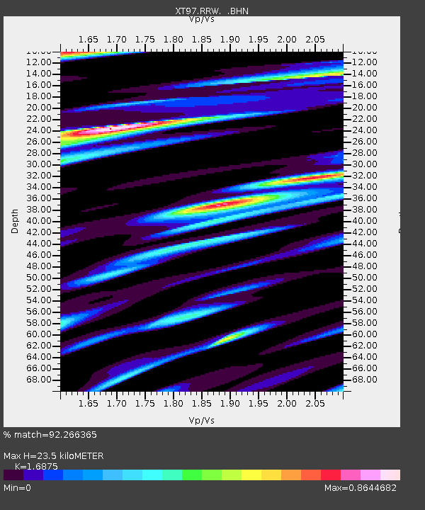
| Estimated Moho Depth: |
23.5 km |
| Estimated Crust Vp/Vs: |
1.69 |
| Assumed Crust Vp: |
6.207 km/s |
| Estimated Crust Vs: |
3.678 km/s |
| Estimated Crust Poisson's Ratio: |
0.23 |
|
| Radial Match: |
92.266365 % |
| Radial Bump: |
400 |
| Transverse Match: |
79.40816 % |
| Transverse Bump: |
400 |
| SOD ConfigId: |
4480 |
| Insert Time: |
2010-03-09 01:44:07.042 +0000 |
| GWidth: |
2.5 |
| Max Bumps: |
400 |
| Tol: |
0.001 |
|

Signal To Noise
| Channel | StoN | STA | LTA |
| XT:RRW: :BHN:19980709T19:45:36.673987Z | 3.3770928 | 4.1002167E-7 | 1.2141261E-7 |
| XT:RRW: :BHE:19980709T19:45:36.673987Z | 2.1488714 | 1.9139917E-7 | 8.906962E-8 |
| XT:RRW: :BHZ:19980709T19:45:36.673987Z | 0.9097653 | 1.2018926E-7 | 1.3211019E-7 |
| Arrivals |
| Ps | 2.8 SECOND |
| PpPs | 9.4 SECOND |
| PsPs/PpSs | 12 SECOND |


