You are here: Home > Network List > XT97 - Colorado BB Array - Lodore Stations List
> Station RRW XT.RRW > Earthquake Result Viewer
RRW XT.RRW - Earthquake Result Viewer
| Earthquake location: |
Fiji Islands Region |
| Earthquake latitude/longitude: |
-17.6/-179.1 |
| Earthquake time(UTC): |
1998/03/29 (088) 19:48:16 GMT |
| Earthquake Depth: |
537 km |
| Earthquake Magnitude: |
6.5 MB, 7.2 UNKNOWN, 7.1 MW |
| Earthquake Catalog/Contributor: |
WHDF/NEIC |
|
| Network: |
XT Colorado BB Array - Lodore |
| Station: |
RRW XT.RRW |
| Lat/Lon: |
41.14 N/108.86 W |
| Elevation: |
2320 m |
|
| Distance: |
87.3 deg |
| Az: |
45.365 deg |
| Baz: |
244.002 deg |
| Ray Param: |
0.041934073 |
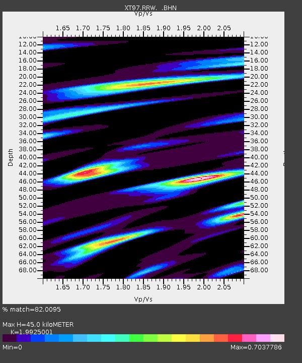
| Estimated Moho Depth: |
45.0 km |
| Estimated Crust Vp/Vs: |
1.99 |
| Assumed Crust Vp: |
6.207 km/s |
| Estimated Crust Vs: |
3.115 km/s |
| Estimated Crust Poisson's Ratio: |
0.33 |
|
| Radial Match: |
82.0095 % |
| Radial Bump: |
400 |
| Transverse Match: |
82.845345 % |
| Transverse Bump: |
400 |
| SOD ConfigId: |
4480 |
| Insert Time: |
2010-03-09 01:44:14.115 +0000 |
| GWidth: |
2.5 |
| Max Bumps: |
400 |
| Tol: |
0.001 |
|

Signal To Noise
| Channel | StoN | STA | LTA |
| XT:RRW: :BHN:19980329T19:59:34.548999Z | 43.421585 | 1.1750327E-5 | 2.706103E-7 |
| XT:RRW: :BHE:19980329T19:59:34.548999Z | 4.2224483 | 1.2618275E-6 | 2.9883788E-7 |
| XT:RRW: :BHZ:19980329T19:59:34.548999Z | 8.148109 | 3.1418529E-6 | 3.8559287E-7 |
| Arrivals |
| Ps | 7.3 SECOND |
| PpPs | 21 SECOND |
| PsPs/PpSs | 29 SECOND |


