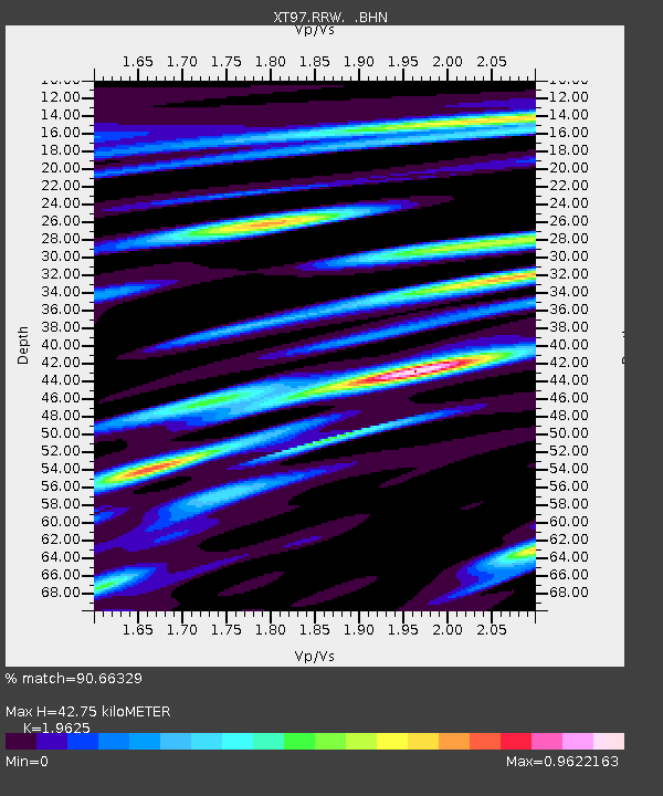
RRW XT.RRW - Earthquake Result Viewer

Earthquake location: Off Coast Of Southern Chile
Earthquake latitude/longitude: -40.3/-74.9
Earthquake time(UTC): 1998/04/01 (091) 22:42:56 GMT
Earthquake Depth: 9.0 km
Earthquake Magnitude: 6.2 MB, 6.0 MS, 6.7 UNKNOWN, 6.6 ME
Earthquake Catalog/Contributor: WHDF/NEIC
Network: XT Colorado BB Array - Lodore
Station: RRW XT.RRW
Lat/Lon: 41.14 N/108.86 W
Elevation: 2320 m
Distance: 86.8 deg
Az: 334.984 deg
Baz: 154.654 deg
Ray Param: 0.043818127
Estimated Moho Depth: 42.75 km
Estimated Crust Vp/Vs: 1.96
Assumed Crust Vp: 6.207 km/s
Estimated Crust Vs: 3.163 km/s
Estimated Crust Poisson's Ratio: 0.32
Radial Match: 90.66329 %
Radial Bump: 400
Transverse Match: 86.02224 %
Transverse Bump: 400
SOD ConfigId: 4480
Insert Time: 2010-03-09 01:44:15.736 +0000
GWidth: 2.5
Max Bumps: 400
Tol: 0.001

Signal To Noise

ChannelStoNSTALTA
XT:RRW: :BHN:19980401T22:55:09.748999Z6.41054152.6304397E-64.1033036E-7
XT:RRW: :BHE:19980401T22:55:09.748999Z1.77066455.6561726E-73.1943787E-7
XT:RRW: :BHZ:19980401T22:55:09.748999Z1.8027584.8269663E-72.6775456E-7
Arrivals
Ps6.8 SECOND
PpPs20 SECOND
PsPs/PpSs27 SECOND