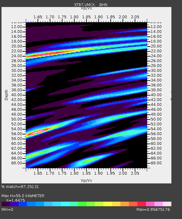
VMCK XT.VMCK - Earthquake Result Viewer

Earthquake location: Near East Coast Of Kamchatka
Earthquake latitude/longitude: 54.8/162.0
Earthquake time(UTC): 1997/12/05 (339) 11:26:54 GMT
Earthquake Depth: 33 km
Earthquake Magnitude: 6.3 MB, 7.6 MS, 7.9 UNKNOWN, 7.3 ME
Earthquake Catalog/Contributor: WHDF/NEIC
Network: XT Colorado BB Array - Lodore
Station: VMCK XT.VMCK
Lat/Lon: 41.08 N/108.71 W
Elevation: 2136 m
Distance: 57.3 deg
Az: 63.882 deg
Baz: 316.606 deg
Ray Param: 0.063496195
Estimated Moho Depth: 55.0 km
Estimated Crust Vp/Vs: 1.65
Assumed Crust Vp: 6.207 km/s
Estimated Crust Vs: 3.768 km/s
Estimated Crust Poisson's Ratio: 0.21
Radial Match: 97.25131 %
Radial Bump: 386
Transverse Match: 92.50098 %
Transverse Bump: 400
SOD ConfigId: 4480
Insert Time: 2010-03-09 01:48:58.260 +0000
GWidth: 2.5
Max Bumps: 400
Tol: 0.001

Signal To Noise

ChannelStoNSTALTA
XT:VMCK: :BHN:19971205T11:36:08.698999Z2.45455176.6874145E-72.7244954E-7
XT:VMCK: :BHE:19971205T11:36:08.698999Z0.57732962.1436993E-73.7131295E-7
XT:VMCK: :BHZ:19971205T11:36:08.698999Z0.82436244.3539197E-75.28156E-7
Arrivals
Ps6.0 SECOND
PpPs22 SECOND
PsPs/PpSs28 SECOND