
Station XT VMCK - XT.VMCK
Network: XT97 - Colorado BB Array - Lodore
Nearby stations (2 deg radius)
| Station | Name | (Lat, Lon) | Start / End | Elevation |
| VMCK | XT.VMCK | (41.08, -108.71) | 1997-08-01 / 1998-07-15 | 2136 m |
| Crust2 Type: | Q4,orogen/43km no ice, Tethian Belt, 5 km seds. |
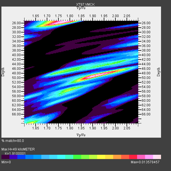
| Thickness Estimate: | 49 km |
| Thickness StdDev: | 14 km |
| Vp/Vs Estimate: | 1.91 |
| Vp/Vs StdDev: | 0.10 |
| Vs Estimate: | 3.25 km/s |
| Poisson's Ratio: | 0.31 |
| Peak Value: | 0.01 |
| Assumed Vp: | 6.207 km/s |
| Ps Weight: | 0.33333334 |
| PpPs Weight: | 0.33333334 |
| PsPs Weight: | 0.33333328 |
| Residual Complexity: | 0.759 |
| Nearby stations H: | +- |
| (2.0 deg) Vp/Vs: | +- |
5 with match > 90% ( 11.111111 %) and 13 with match > 80% ( 28.88889 %) out of 45.
Download stack as xyz text file.
Azimuth Distribution of Events:

Prior Results for this Station
| Study | Thickness | Vp/Vs | Vp | Vs | Poissons Ratio | Extra |
| EARS | 49 km | 1.91 | 6.207 km/s | 3.25 km/s | 0.31 | |
| Crust2.0 | 43 km | 1.76 | 6.207 km/s | 3.535 km/s | 0.26 | Q4,orogen/43km no ice, Tethian Belt, 5 km seds. |
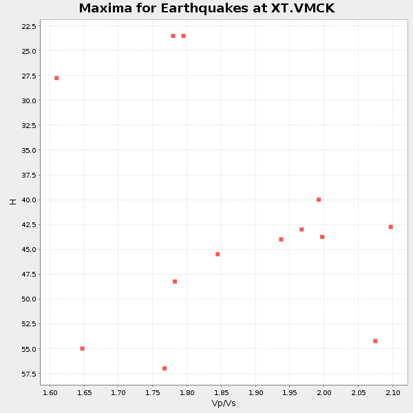
| Global Maxima | 49 km | 1.91 | 6.207 km/s | 3.25 km/s | 0.31 | amp=0.013578457 |
| Local Maxima 1 | 26 km | 1.76 | 6.207 km/s | 3.532 km/s | 0.26 | amp=0.013242037 |
| Local Maxima 2 | 70 km | 1.63 | 6.207 km/s | 3.814 km/s | 0.20 | amp=0.008418353 |
| Local Maxima 3 | 47 km | 1.76 | 6.207 km/s | 3.532 km/s | 0.26 | amp=0.007546714 |
| Local Maxima 4 | 25 km | 1.74 | 6.207 km/s | 3.578 km/s | 0.25 | amp=0.006356682 |
| Predicted Arrivals for vertical incidence (zero ray parameter) | |
| Ps | 7.18 SECOND |
| PpPs | 22.97 SECOND |
| PsPs/PpSs | 30.16 SECOND |
Events Processed for this Station
Download zip of receiver functions as SAC
Plot maxima for each earthquake.
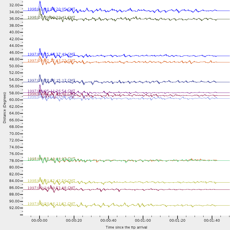
Events Used in the Stack
(13 events)| Radial Match | Distance | Baz | FERegion | Time | Lat/Lon | Depth | Magnitude |
| 97.25131 | 57.3 deg | 316.606 deg | Near East Coast Of Kamchatka | 1997/12/05 11:26:54 GMT | (54.8, 162.0) | 33 km | 6.3 MB, 7.6 MS, 7.9 UNKNOWN, 7.3 ME |
| 96.156944 | 89.0 deg | 239.358 deg | South Of Fiji Islands | 1997/10/14 09:53:18 GMT | (-22.1, -176.8) | 167 km | 6.7 MB, 7.7 UNKNOWN, 7.4 ME |
| 95.62418 | 79.6 deg | 147.878 deg | Near Coast Of Central Chile | 1997/10/15 01:03:33 GMT | (-30.9, -71.2) | 58 km | 6.8 MB, 6.8 MS, 7.3 UNKNOWN, 7.1 MW |
| 91.77496 | 86.7 deg | 154.756 deg | Off Coast Of Southern Chile | 1998/04/01 22:42:56 GMT | (-40.3, -74.9) | 9.0 km | 6.2 MB, 6.0 MS, 6.7 UNKNOWN, 6.6 ME |
| 91.76195 | 53.9 deg | 139.103 deg | Northern Peru | 1997/10/28 06:15:17 GMT | (-4.4, -76.7) | 112 km | 6.6 MB, 6.3 MS, 7.2 UNKNOWN, 6.6 ME |
| 89.195724 | 45.3 deg | 175.774 deg | Central East Pacific Rise | 1997/08/15 07:37:49 GMT | (-4.4, -105.7) | 10 km | 5.3 MB, 5.8 MS, 6.2 UNKNOWN, 6.1 MW |
| 88.89641 | 33.3 deg | 320.882 deg | Southern Alaska | 1998/07/09 19:39:43 GMT | (60.5, -153.2) | 145 km | 5.3 MB, 6.2 UNKNOWN, 6.2 MW |
| 84.74924 | 47.4 deg | 132.509 deg | Colombia | 1997/09/02 12:13:22 GMT | (3.8, -75.7) | 199 km | 6.5 MB, 6.8 UNKNOWN, 6.4 ME |
| 84.49791 | 94.2 deg | 235.289 deg | Kermadec Islands Region | 1997/09/20 16:11:32 GMT | (-28.7, -177.6) | 30 km | 6.1 MB, 7.0 MS, 7.2 UNKNOWN, 6.7 ME |
| 84.168076 | 59.3 deg | 315.192 deg | Off East Coast Of Kamchatka | 1998/06/01 05:34:03 GMT | (52.9, 160.1) | 44 km | 6.2 MB, 6.3 MS, 6.5 UNKNOWN, 6.4 MW |
| 83.5714 | 79.6 deg | 148.049 deg | Near Coast Of Central Chile | 1998/01/12 10:14:07 GMT | (-31.0, -71.4) | 35 km | 5.8 MB, 6.2 MS, 6.6 UNKNOWN, 6.2 ME |
| 82.95591 | 30.5 deg | 145.599 deg | Guatemala | 1998/01/10 08:20:05 GMT | (14.4, -91.5) | 33 km | 6.1 MB, 6.2 MS, 6.6 UNKNOWN, 6.6 ME |
| 81.92701 | 58.3 deg | 138.827 deg | Peru-Brazil Border Region | 1998/04/03 22:01:48 GMT | (-8.1, -74.2) | 165 km | 6.1 MB, 5.6 MS, 6.6 UNKNOWN, 6.6 MW |
Losers
(32 events)| Radial Match | Distance | Baz | FERegion | Time | Lat/Lon | Depth | Magnitude | Reason |
| 89.50752 | 87.4 deg | 244.105 deg | Fiji Islands Region | 1998/03/29 19:48:16 GMT | (-17.6, -179.1) | 537 km | 6.5 MB, 7.2 UNKNOWN, 7.1 MW | |
| 89.112564 | 57.0 deg | 316.155 deg | Near East Coast Of Kamchatka | 1997/12/07 17:56:18 GMT | (54.7, 162.9) | 33 km | 5.6 MB, 6.0 MS, 6.3 UNKNOWN, 6.1 MW | |
| 87.60085 | 73.9 deg | 143.627 deg | Near Coast Of Northern Chile | 1998/01/30 12:16:08 GMT | (-23.9, -70.2) | 42 km | 6.3 MB, 6.5 MS, 7.0 UNKNOWN, 6.7 ME | |
| 78.950424 | 96.3 deg | 234.846 deg | Kermadec Islands, New Zealand | 1998/07/09 14:45:39 GMT | (-30.5, -179.0) | 130 km | 6.2 MB, 6.2 MS, 6.9 UNKNOWN, 6.4 ME | |
| 78.646545 | 49.3 deg | 307.663 deg | Rat Islands, Aleutian Islands | 1997/12/17 04:38:51 GMT | (51.2, 178.9) | 20 km | 5.8 MB, 6.5 MS, 6.7 UNKNOWN, 6.1 ME | |
| 77.08316 | 32.2 deg | 141.555 deg | El Salvador | 1997/12/18 15:02:00 GMT | (13.8, -88.7) | 182 km | 5.3 MB, 6.1 UNKNOWN, 6.0 MW | |
| 76.601845 | 90.9 deg | 241.068 deg | South Of Fiji Islands | 1998/05/16 02:22:03 GMT | (-22.2, -179.5) | 586 km | 6.1 MB, 6.8 UNKNOWN | |
| 76.49235 | 30.5 deg | 145.582 deg | Guatemala | 1998/03/03 02:24:43 GMT | (14.4, -91.5) | 63 km | 5.5 MB, 5.4 MS, 6.2 UNKNOWN, 6.1 MW | |
| 76.35069 | 65.9 deg | 136.894 deg | Peru-Bolivia Border Region | 1997/11/28 22:53:41 GMT | (-13.7, -68.8) | 586 km | 6.4 MB, 6.6 UNKNOWN, 6.6 MW | |
| 74.1671 | 89.6 deg | 159.724 deg | Off Coast Of Southern Chile | 1998/01/19 18:23:59 GMT | (-45.0, -79.5) | 10 km | 5.5 MS, 5.4 MB, 6.2 UNKNOWN, 6.2 MW | |
| 69.66933 | 95.3 deg | 239.312 deg | South Of Fiji Islands | 1997/09/04 04:23:37 GMT | (-26.6, 178.3) | 625 km | 6.3 MB, 6.8 UNKNOWN, 6.5 ME | |
| 68.50415 | 58.0 deg | 315.768 deg | Off East Coast Of Kamchatka | 1997/12/05 11:35:19 GMT | (53.9, 161.6) | 33 km | 5.7 MB | |
| 68.17027 | 90.7 deg | 37.671 deg | Southern Greece | 1997/10/13 13:39:37 GMT | (36.4, 22.1) | 24 km | 6.2 MB, 6.6 MS, 6.7 UNKNOWN, 6.5 MW | |
| 67.291855 | 82.5 deg | 306.032 deg | Southeast Of Honshu, Japan | 1997/09/30 06:27:24 GMT | (32.0, 141.9) | 10 km | 5.5 MB, 6.5 MS, 6.1 UNKNOWN, 6.0 MW | |
| 65.78623 | 81.5 deg | 145.59 deg | San Juan Province, Argentina | 1998/06/07 16:10:46 GMT | (-31.5, -67.8) | 113 km | 5.6 MB, 5.9 UNKNOWN, 5.9 MW | |
| 65.62597 | 30.4 deg | 147.181 deg | Near Coast Of Chiapas, Mexico | 1997/12/25 22:16:19 GMT | (14.1, -92.3) | 10 km | 5.4 MB, 5.3 MS, 5.8 UNKNOWN, 5.5 MD | |
| 63.856018 | 31.5 deg | 144.971 deg | Near Coast Of Guatemala | 1998/05/10 06:05:58 GMT | (13.7, -90.7) | 33 km | 5.3 MB, 5.9 MS, 6.3 UNKNOWN, 5.3 MD | |
| 57.55223 | 60.7 deg | 140.641 deg | Central Peru | 1998/02/19 04:21:30 GMT | (-11.0, -74.4) | 33 km | 5.8 MB, 5.4 MS, 6.0 UNKNOWN, 5.9 MW | |
| 57.146275 | 80.9 deg | 309.298 deg | Near East Coast Of Honshu, Japan | 1998/06/14 13:17:08 GMT | (35.4, 140.5) | 45 km | 5.5 MB, 5.3 MS, 5.8 UNKNOWN, 5.8 MW | |
| 57.001328 | 94.3 deg | 256.487 deg | Vanuatu Islands | 1997/10/31 12:29:49 GMT | (-13.1, 166.9) | 183 km | 5.9 UNKNOWN, 5.4 MB | |
| 54.792473 | 59.9 deg | 314.714 deg | Off East Coast Of Kamchatka | 1998/05/27 20:41:37 GMT | (52.2, 159.5) | 60 km | 5.5 MB, 6.0 UNKNOWN, 5.9 MW | |
| 53.356297 | 73.4 deg | 141.385 deg | Northern Chile | 1997/09/28 23:13:13 GMT | (-22.4, -68.4) | 107 km | 5.7 MB, 5.6 UNKNOWN, 5.6 MW | |
| 52.931538 | 87.5 deg | 300.974 deg | Volcano Islands, Japan Region | 1998/02/07 01:13:36 GMT | (24.8, 141.8) | 526 km | 5.9 UNKNOWN, 5.4 MB | |
| 52.872746 | 92.3 deg | 240.16 deg | South Of Fiji Islands | 1998/04/14 03:41:22 GMT | (-23.8, -179.9) | 499 km | 5.5 MB, 6.2 UNKNOWN, 6.1 MW | |
| 52.798355 | 85.1 deg | 40.351 deg | Southern Italy | 1998/05/18 17:19:04 GMT | (39.3, 15.1) | 280 km | 5.6 MB | |
| 50.66787 | 95.7 deg | 28.26 deg | Turkey | 1998/06/27 13:55:52 GMT | (36.9, 35.3) | 33 km | 5.8 MB, 6.2 MS, 6.3 UNKNOWN, 6.3 ME | |
| 49.26168 | 96.2 deg | 234.322 deg | Kermadec Islands, New Zealand | 1997/10/27 09:32:59 GMT | (-30.8, -178.5) | 33 km | 5.5 MB, 5.4 MS | |
| 46.992397 | 88.8 deg | 240.935 deg | Fiji Islands Region | 1997/08/25 11:59:00 GMT | (-20.8, -177.8) | 394 km | 5.5 UNKNOWN, 5.3 MB | |
| 45.770954 | 91.1 deg | 241.1 deg | South Of Fiji Islands | 1997/12/26 05:34:24 GMT | (-22.3, -179.7) | 588 km | 5.9 UNKNOWN, 5.3 MB, 5.8 MW | |
| 44.539803 | 95.4 deg | 234.468 deg | Kermadec Islands, New Zealand | 1998/06/20 20:24:45 GMT | (-30.1, -177.9) | 57 km | 5.7 MB, 6.0 UNKNOWN, 6.0 MW | |
| 42.654415 | 92.7 deg | 291.333 deg | Mariana Islands | 1998/05/15 05:58:06 GMT | (14.2, 144.9) | 154 km | 5.7 MB, 6.0 UNKNOWN, 6.0 MW | |
| 35.49608 | 76.7 deg | 310.372 deg | Off East Coast Of Honshu, Japan | 1998/05/30 18:18:15 GMT | (39.0, 143.4) | 33 km | 5.7 MB, 5.7 MS, 6.2 UNKNOWN, 6.0 MW |
