You are here: Home > Network List > JP - Japan Meteorological Agency Seismic Network Stations List
> Station JEM Erimo > Earthquake Result Viewer
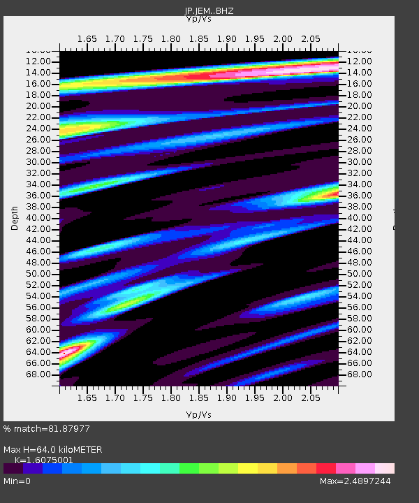
JEM Erimo - Earthquake Result Viewer
| Earthquake location: |
Eastern New Guinea Reg., P.N.G. |
| Earthquake latitude/longitude: |
-6.1/146.2 |
| Earthquake time(UTC): |
2020/10/08 (282) 07:35:32 GMT |
| Earthquake Depth: |
116 km |
| Earthquake Magnitude: |
6.7 Mi |
| Earthquake Catalog/Contributor: |
NEIC PDE/at |
|
| Network: |
JP Japan Meteorological Agency Seismic Network |
| Station: |
JEM Erimo |
| Lat/Lon: |
42.02 N/143.15 E |
| Elevation: |
40 m |
|
| Distance: |
48.0 deg |
| Az: |
356.907 deg |
| Baz: |
175.871 deg |
| Ray Param: |
0.06926466 |
| Estimated Moho Depth: |
64.0 km |
| Estimated Crust Vp/Vs: |
1.61 |
| Assumed Crust Vp: |
6.461 km/s |
| Estimated Crust Vs: |
4.02 km/s |
| Estimated Crust Poisson's Ratio: |
0.18 |
|
| Radial Match: |
81.87977 % |
| Radial Bump: |
400 |
| Transverse Match: |
84.231995 % |
| Transverse Bump: |
400 |
| SOD ConfigId: |
22732711 |
| Insert Time: |
2020-10-22 07:44:43.371 +0000 |
| GWidth: |
2.5 |
| Max Bumps: |
400 |
| Tol: |
0.001 |
|

Signal To Noise
| Channel | StoN | STA | LTA |
| JP:JEM: :BHZ:20201008T07:43:44.750Z | 3.0578194 | 5.4973106E-7 | 1.7977878E-7 |
| JP:JEM: :BHN:20201008T07:43:44.750Z | 4.029474 | 8.7007834E-7 | 2.1592852E-7 |
| JP:JEM: :BHE:20201008T07:43:44.750Z | 1.926712 | 3.7302368E-7 | 1.9360635E-7 |
| Arrivals |
| Ps | 6.4 SECOND |
| PpPs | 24 SECOND |
| PsPs/PpSs | 31 SECOND |


