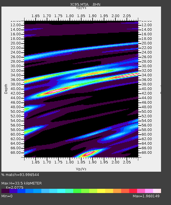
MTJA Mt John - Earthquake Result Viewer
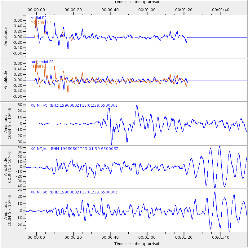
Earthquake location: Solomon Islands
Earthquake latitude/longitude: -10.8/161.4
Earthquake time(UTC): 1996/08/02 (215) 12:55:29 GMT
Earthquake Depth: 33 km
Earthquake Magnitude: 6.2 MB, 7.1 MS, 6.9 UNKNOWN, 6.9 MW
Earthquake Catalog/Contributor: WHDF/NEIC
Network: XC Southern Alps Passive Seismic Experiment
Station: MTJA Mt John
Lat/Lon: 43.99 S/170.46 E
Elevation: 1042 m
Distance: 34.0 deg
Az: 168.325 deg
Baz: 344.01 deg
Ray Param: 0.07789389
Estimated Moho Depth: 33.5 km
Estimated Crust Vp/Vs: 2.08
Assumed Crust Vp: 6.461 km/s
Estimated Crust Vs: 3.11 km/s
Estimated Crust Poisson's Ratio: 0.35
Radial Match: 93.996544 %
Radial Bump: 294
Transverse Match: 75.11357 %
Transverse Bump: 400
SOD ConfigId: 6273
Insert Time: 2010-02-26 15:08:43.406 +0000
GWidth: 2.5
Max Bumps: 400
Tol: 0.001

Signal To Noise

ChannelStoNSTALTA
XC:MTJA: :BHN:19960802T13:01:39.650006Z1.68705811.3215536E-67.8334796E-7
XC:MTJA: :BHE:19960802T13:01:39.650006Z0.902331236.5587574E-77.2686805E-7
XC:MTJA: :BHZ:19960802T13:01:39.650006Z3.97646262.120092E-65.331603E-7
Arrivals
Ps6.0 SECOND
PpPs15 SECOND
PsPs/PpSs21 SECOND