
Station XC MTJA - Mt John
Network: XC95 - Southern Alps Passive Seismic Experiment
Nearby stations (2 deg radius)
| Station | Name | (Lat, Lon) | Start / End | Elevation |
| MTJA | Mt John | (-43.99, 170.46) | 1995-11-14 / 1996-12-31 | 1042 m |
| Crust2 Type: | K2,forearc, New Zealand, 0.7 km seds. |
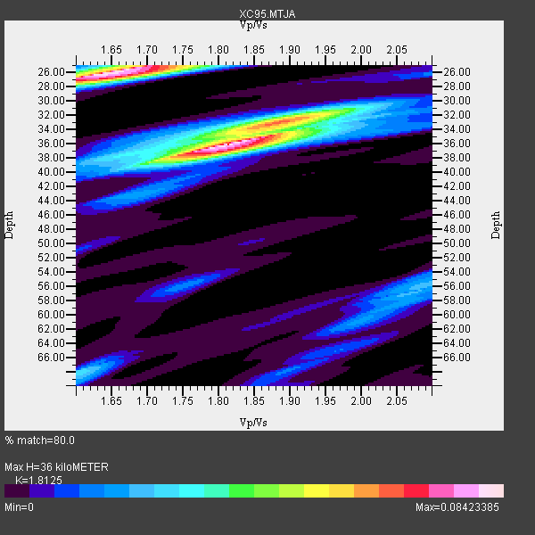
| Thickness Estimate: | 36 km |
| Thickness StdDev: | 5.6 km |
| Vp/Vs Estimate: | 1.81 |
| Vp/Vs StdDev: | 0.11 |
| Vs Estimate: | 3.565 km/s |
| Poisson's Ratio: | 0.28 |
| Peak Value: | 0.08 |
| Assumed Vp: | 6.461 km/s |
| Ps Weight: | 0.33333334 |
| PpPs Weight: | 0.33333334 |
| PsPs Weight: | 0.33333328 |
| Residual Complexity: | 0.673 |
| Nearby stations H: | +- |
| (2.0 deg) Vp/Vs: | +- |
1 with match > 90% ( 4.347826 %) and 4 with match > 80% ( 17.391304 %) out of 23.
Download stack as xyz text file.
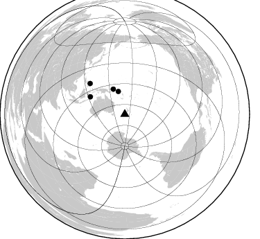
Azimuth Distribution of Events:
Prior Results for this Station
| Study | Thickness | Vp/Vs | Vp | Vs | Poissons Ratio | Extra |
| EARS | 36 km | 1.81 | 6.461 km/s | 3.565 km/s | 0.28 | |
| Crust2.0 | 35 km | 1.76 | 6.461 km/s | 3.663 km/s | 0.26 | K2,forearc, New Zealand, 0.7 km seds. |
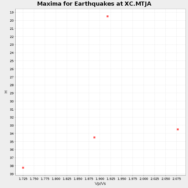
| Global Maxima | 36 km | 1.81 | 6.461 km/s | 3.565 km/s | 0.28 | amp=0.08423385 |
| Local Maxima 1 | 26 km | 1.64 | 6.461 km/s | 3.934 km/s | 0.21 | amp=0.08269328 |
| Local Maxima 2 | 33 km | 1.89 | 6.461 km/s | 3.41 km/s | 0.31 | amp=0.051536225 |
| Local Maxima 3 | 68 km | 1.60 | 6.461 km/s | 4.038 km/s | 0.18 | amp=0.027566137 |
| Local Maxima 4 | 56 km | 2.09 | 6.461 km/s | 3.095 km/s | 0.35 | amp=0.021768456 |
| Predicted Arrivals for vertical incidence (zero ray parameter) | |
| Ps | 4.53 SECOND |
| PpPs | 15.67 SECOND |
| PsPs/PpSs | 20.20 SECOND |
Events Processed for this Station
Download zip of receiver functions as SAC
Plot maxima for each earthquake.
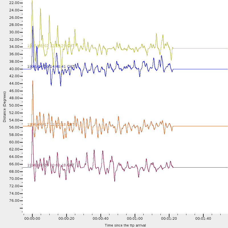
Events Used in the Stack
(4 events)| Radial Match | Distance | Baz | FERegion | Time | Lat/Lon | Depth | Magnitude |
| 93.996544 | 34.0 deg | 344.01 deg | Solomon Islands | 1996/08/02 12:55:29 GMT | (-10.8, 161.4) | 33 km | 6.2 MB, 7.1 MS, 6.9 UNKNOWN, 6.9 MW |
| 83.92664 | 55.5 deg | 296.785 deg | Flores Sea | 1996/06/17 11:22:18 GMT | (-7.1, 122.6) | 587 km | 6.6 MB, 7.9 UNKNOWN, 7.8 MW |
| 82.86601 | 39.7 deg | 335.498 deg | Solomon Islands | 1996/04/29 14:40:41 GMT | (-6.5, 155.0) | 44 km | 6.3 MB, 7.5 MS, 7.2 UNKNOWN, 6.8 ME |
| 82.08767 | 66.7 deg | 311.552 deg | Mindanao, Philippines | 1996/09/20 00:03:18 GMT | (9.6, 126.3) | 33 km | 5.8 MB, 6.2 MS, 6.4 UNKNOWN, 6.4 MW |
Losers
(19 events)| Radial Match | Distance | Baz | FERegion | Time | Lat/Lon | Depth | Magnitude | Reason |
| 79.97481 | 66.6 deg | 311.464 deg | Mindanao, Philippines | 1996/09/20 04:10:27 GMT | (9.5, 126.3) | 33 km | 5.8 MB, 6.4 MS, 6.6 UNKNOWN, 6.6 MW | |
| 75.57064 | 31.9 deg | 31.107 deg | Tonga Islands | 1996/08/05 02:08:58 GMT | (-15.3, -173.1) | 41 km | 6.0 MB, 6.7 MS, 6.7 UNKNOWN, 6.2 ME | |
| 74.50835 | 59.3 deg | 304.156 deg | Southern Molucca Sea | 1996/08/12 17:00:27 GMT | (-0.3, 125.1) | 42 km | 5.7 MB, 5.5 MS, 6.1 UNKNOWN, 6.0 MW | |
| 71.91759 | 63.1 deg | 300.826 deg | Minahassa Peninsula, Sulawesi | 1996/07/22 14:19:35 GMT | (1.0, 120.4) | 33 km | 6.0 MB, 6.9 MS, 7.0 UNKNOWN, 6.9 MW | |
| 71.864914 | 41.6 deg | 336.148 deg | Solomon Islands | 1996/05/02 13:34:28 GMT | (-4.5, 154.8) | 500 km | 5.6 MB, 6.6 UNKNOWN, 6.5 MW | |
| 70.167274 | 91.3 deg | 337.504 deg | Eastern Sea Of Japan | 1996/12/22 14:53:27 GMT | (43.2, 138.9) | 227 km | 6.0 MB, 6.5 UNKNOWN, 6.5 MW | |
| 68.93075 | 79.4 deg | 314.549 deg | Taiwan Region | 1996/09/05 23:42:06 GMT | (21.9, 121.5) | 20 km | 6.4 MB, 6.6 MS, 6.8 UNKNOWN, 6.8 ME | |
| 66.424446 | 61.7 deg | 306.286 deg | Talaud Islands, Indonesia | 1996/03/04 15:59:05 GMT | (2.8, 125.2) | 151 km | 5.8 MB, 5.9 UNKNOWN, 5.9 MW | |
| 65.09853 | 76.7 deg | 332.273 deg | Bonin Islands, Japan Region | 1996/06/26 03:22:03 GMT | (27.7, 139.7) | 469 km | 5.5 MB, 6.3 UNKNOWN, 5.4 MB | |
| 65.07874 | 95.4 deg | 8.038 deg | Andreanof Islands, Aleutian Is. | 1996/06/10 15:36:29 GMT | (51.2, -176.8) | 33 km | 5.5 MB | |
| 64.86761 | 30.5 deg | 353.605 deg | Vanuatu Islands | 1996/06/10 01:04:46 GMT | (-13.5, 167.1) | 200 km | 5.8 MB, 5.9 MS, 6.7 UNKNOWN, 6.0 MS | |
| 64.6911 | 95.8 deg | 353.364 deg | Off East Coast Of Kamchatka | 1996/06/30 11:32:35 GMT | (51.7, 159.8) | 33 km | 5.5 MB, 5.9 MS, 6.1 UNKNOWN, 6.0 MW | |
| 61.053455 | 70.4 deg | 332.795 deg | Mariana Islands Region | 1996/07/06 21:36:28 GMT | (22.0, 142.8) | 241 km | 5.8 MB, 6.3 UNKNOWN, 6.2 MW | |
| 58.127533 | 85.6 deg | 131.119 deg | Near Coast Of Central Chile | 1996/09/09 00:20:39 GMT | (-31.9, -71.6) | 39 km | 6.0 MB, 5.5 MS, 6.0 UNKNOWN, 5.8 ME | |
| 57.9232 | 60.8 deg | 302.345 deg | Minahassa Peninsula, Sulawesi | 1996/08/01 04:08:23 GMT | (-0.0, 122.9) | 149 km | 5.5 MB, 5.6 UNKNOWN, 5.5 MW | |
| 55.337383 | 60.9 deg | 302.223 deg | Minahassa Peninsula, Sulawesi | 1996/09/14 02:53:24 GMT | (-0.0, 122.8) | 181 km | 5.5 MB | |
| 51.65633 | 58.4 deg | 325.865 deg | W. Caroline Islands, Micronesia | 1996/07/04 15:50:38 GMT | (8.5, 141.6) | 33 km | 5.1 MB, 5.4 MS, 6.0 UNKNOWN, 5.9 MW | |
| 50.172688 | 63.3 deg | 300.665 deg | Minahassa Peninsula, Sulawesi | 1996/07/16 10:07:36 GMT | (1.0, 120.3) | 33 km | 6.0 MB, 6.4 MS, 6.6 UNKNOWN, 6.6 MW | |
| 49.23088 | 68.9 deg | 312.104 deg | Samar, Philippines | 1996/10/02 09:48:01 GMT | (11.8, 125.5) | 33 km | 6.0 MB, 6.4 MS, 6.4 UNKNOWN, 6.3 MW |
