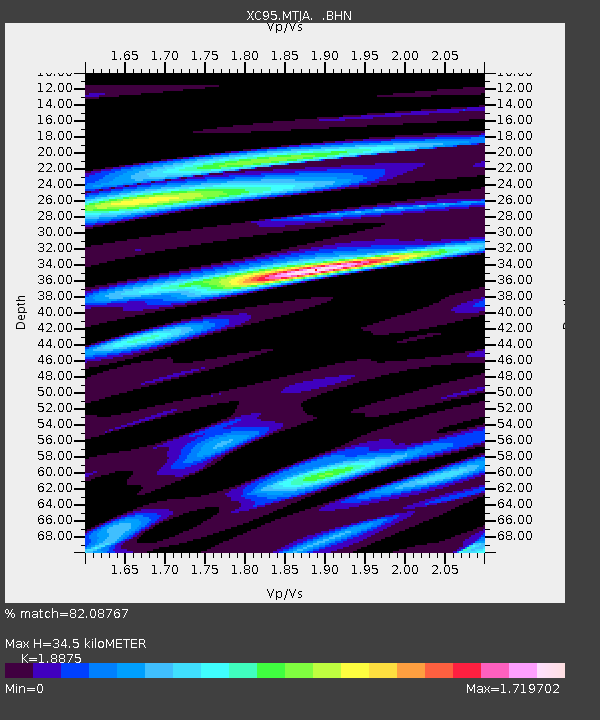
MTJA Mt John - Earthquake Result Viewer
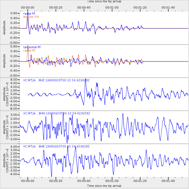
Earthquake location: Mindanao, Philippines
Earthquake latitude/longitude: 9.6/126.3
Earthquake time(UTC): 1996/09/20 (264) 00:03:18 GMT
Earthquake Depth: 33 km
Earthquake Magnitude: 5.8 MB, 6.2 MS, 6.4 UNKNOWN, 6.4 MW
Earthquake Catalog/Contributor: WHDF/NEIC
Network: XC Southern Alps Passive Seismic Experiment
Station: MTJA Mt John
Lat/Lon: 43.99 S/170.46 E
Elevation: 1042 m
Distance: 66.7 deg
Az: 146.787 deg
Baz: 311.552 deg
Ray Param: 0.05740697
Estimated Moho Depth: 34.5 km
Estimated Crust Vp/Vs: 1.89
Assumed Crust Vp: 6.461 km/s
Estimated Crust Vs: 3.423 km/s
Estimated Crust Poisson's Ratio: 0.30
Radial Match: 82.08767 %
Radial Bump: 400
Transverse Match: 78.03695 %
Transverse Bump: 400
SOD ConfigId: 6273
Insert Time: 2010-02-26 15:08:44.265 +0000
GWidth: 2.5
Max Bumps: 400
Tol: 0.001

Signal To Noise

ChannelStoNSTALTA
XC:MTJA: :BHN:19960920T00:13:34.929028Z1.37093138.884396E-76.480555E-7
XC:MTJA: :BHE:19960920T00:13:34.929028Z1.18702425.7840504E-74.8727316E-7
XC:MTJA: :BHZ:19960920T00:13:34.929028Z1.9050659.023286E-74.7364716E-7
Arrivals
Ps4.9 SECOND
PpPs15 SECOND
PsPs/PpSs20 SECOND