You are here: Home > Network List > XT01 - Seismic Array in Fiji and Tonga Stations List
> Station NAQA Naqila > Earthquake Result Viewer
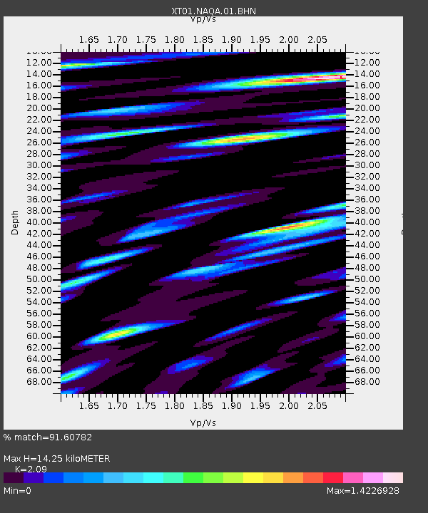
NAQA Naqila - Earthquake Result Viewer
| Earthquake location: |
E. Russia-N.E. China Border Reg. |
| Earthquake latitude/longitude: |
43.8/130.7 |
| Earthquake time(UTC): |
2002/06/28 (179) 17:19:30 GMT |
| Earthquake Depth: |
566 km |
| Earthquake Magnitude: |
6.7 MB, 7.3 MW, 7.3 MW |
| Earthquake Catalog/Contributor: |
WHDF/NEIC |
|
| Network: |
XT Seismic Array in Fiji and Tonga |
| Station: |
NAQA Naqila |
| Lat/Lon: |
17.96 S/178.39 E |
| Elevation: |
83 m |
|
| Distance: |
75.4 deg |
| Az: |
133.289 deg |
| Baz: |
326.347 deg |
| Ray Param: |
0.049904477 |
| Estimated Moho Depth: |
14.25 km |
| Estimated Crust Vp/Vs: |
2.09 |
| Assumed Crust Vp: |
5.195 km/s |
| Estimated Crust Vs: |
2.486 km/s |
| Estimated Crust Poisson's Ratio: |
0.35 |
|
| Radial Match: |
91.60782 % |
| Radial Bump: |
400 |
| Transverse Match: |
86.096954 % |
| Transverse Bump: |
400 |
| SOD ConfigId: |
16820 |
| Insert Time: |
2010-03-09 01:51:59.449 +0000 |
| GWidth: |
2.5 |
| Max Bumps: |
400 |
| Tol: |
0.001 |
|

Signal To Noise
| Channel | StoN | STA | LTA |
| XT:NAQA:01:BHN:20020628T17:29:45.207012Z | 1.073955 | 4.53133E-7 | 4.219292E-7 |
| XT:NAQA:01:BHE:20020628T17:29:45.207012Z | 1.1342287 | 4.871779E-7 | 4.2952348E-7 |
| XT:NAQA:01:BHZ:20020628T17:29:45.207012Z | 6.921831 | 2.5690272E-6 | 3.711485E-7 |
| Arrivals |
| Ps | 3.0 SECOND |
| PpPs | 8.3 SECOND |
| PsPs/PpSs | 11 SECOND |


