
Station XT NAQA - Naqila
Network: XT01 - Seismic Array in Fiji and Tonga
Nearby stations (2 deg radius)
| Station | Name | (Lat, Lon) | Start / End | Elevation |
| NAQA | Naqila | (-17.96, 178.39) | 2001-07-25 / 2002-12-31 | 0.1 km |
| Crust2 Type: | B6,thick melt affected o.c., 0.5 km seds. |
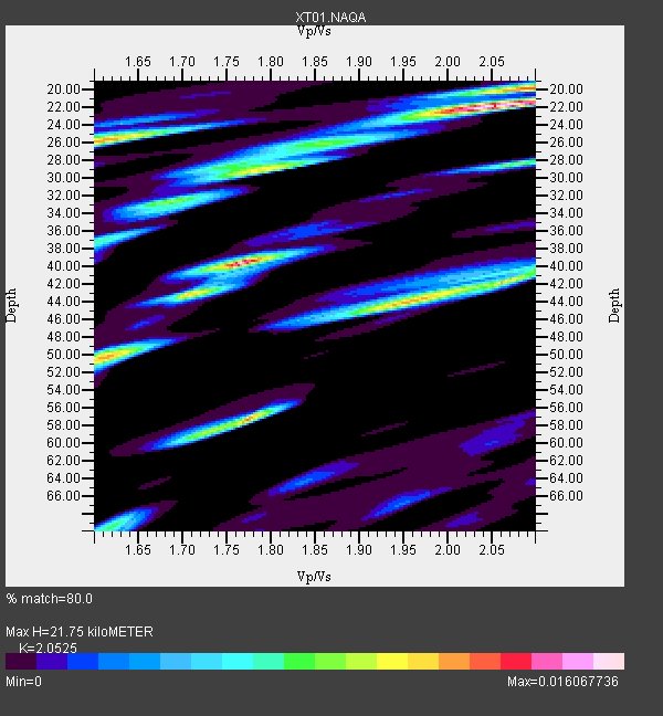
| Thickness Estimate: | 22 km |
| Thickness StdDev: | 8.6 km |
| Vp/Vs Estimate: | 2.05 |
| Vp/Vs StdDev: | 0.17 |
| Vs Estimate: | 2.531 km/s |
| Poisson's Ratio: | 0.34 |
| Peak Value: | 0.02 |
| Assumed Vp: | 5.195 km/s |
| Ps Weight: | 0.33333334 |
| PpPs Weight: | 0.33333334 |
| PsPs Weight: | 0.33333328 |
| Residual Complexity: | 0.803 |
| Nearby stations H: | +- |
| (2.0 deg) Vp/Vs: | +- |
2 with match > 90% ( 40.0 %) and 5 with match > 80% ( 100.0 %) out of 5.
Download stack as xyz text file.
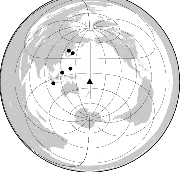
Azimuth Distribution of Events:
Prior Results for this Station
| Study | Thickness | Vp/Vs | Vp | Vs | Poissons Ratio | Extra |
| EARS | 22 km | 2.05 | 5.195 km/s | 2.531 km/s | 0.34 | |
| Crust2.0 | 24 km | 1.98 | 5.195 km/s | 2.627 km/s | 0.33 | B6,thick melt affected o.c., 0.5 km seds. |
| Global Maxima | 22 km | 2.05 | 5.195 km/s | 2.531 km/s | 0.34 | amp=0.016067736 |
| Local Maxima 1 | 40 km | 1.76 | 5.195 km/s | 2.943 km/s | 0.26 | amp=0.015630793 |
| Local Maxima 2 | 57 km | 1.77 | 5.195 km/s | 2.931 km/s | 0.27 | amp=0.012124228 |
| Local Maxima 3 | 50 km | 1.61 | 5.195 km/s | 3.227 km/s | 0.19 | amp=0.011030715 |
| Local Maxima 4 | 42 km | 2.07 | 5.195 km/s | 2.513 km/s | 0.35 | amp=0.010522038 |
| Predicted Arrivals for vertical incidence (zero ray parameter) | |
| Ps | 4.41 SECOND |
| PpPs | 12.78 SECOND |
| PsPs/PpSs | 17.19 SECOND |
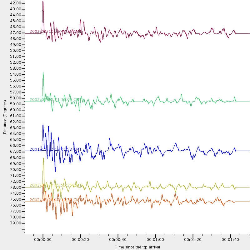
Events Processed for this Station
Download zip of receiver functions as SAC
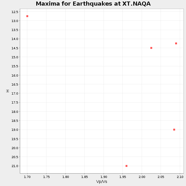
Plot maxima for each earthquake.
Events Used in the Stack
(5 events)| Radial Match | Distance | Baz | FERegion | Time | Lat/Lon | Depth | Magnitude |
| 93.574104 | 58.5 deg | 289.029 deg | Mindanao, Philippines | 2002/03/05 21:16:09 GMT | (6.0, 124.2) | 31 km | 6.3 MB, 7.2 MS, 7.5 MW, 7.2 MW |
| 91.60782 | 75.4 deg | 326.347 deg | E. Russia-N.E. China Border Reg. | 2002/06/28 17:19:30 GMT | (43.8, 130.7) | 566 km | 6.7 MB, 7.3 MW, 7.3 MW |
| 87.555695 | 66.9 deg | 329.299 deg | Eastern Honshu, Japan | 2001/12/02 13:01:53 GMT | (39.4, 141.1) | 124 km | 6.1 MB, 6.5 MW, 6.5 MW |
| 86.99803 | 72.9 deg | 268.093 deg | Sunda Strait, Indonesia | 2002/06/27 05:50:35 GMT | (-7.0, 104.2) | 11 km | 6.0 MB, 6.9 MS, 6.6 MW, 6.5 MW |
| 80.39502 | 47.0 deg | 304.868 deg | W. Caroline Islands, Micronesia | 2002/06/10 22:48:36 GMT | (11.0, 140.7) | 33 km | 5.9 MB, 5.9 MS, 6.1 MW, 6.0 MW |
Losers
(0 events)| Radial Match | Distance | Baz | FERegion | Time | Lat/Lon | Depth | Magnitude | Reason |
