You are here: Home > Network List > XC95 - Southern Alps Passive Seismic Experiment Stations List
> Station MTJA Mt John > Earthquake Result Viewer
MTJA Mt John - Earthquake Result Viewer
*The percent match for this event was below the threshold and hence no stack was calculated.
| Earthquake location: |
Eastern Sea Of Japan |
| Earthquake latitude/longitude: |
43.2/138.9 |
| Earthquake time(UTC): |
1996/12/22 (357) 14:53:27 GMT |
| Earthquake Depth: |
227 km |
| Earthquake Magnitude: |
6.0 MB, 6.5 UNKNOWN, 6.5 MW |
| Earthquake Catalog/Contributor: |
WHDF/NEIC |
|
| Network: |
XC Southern Alps Passive Seismic Experiment |
| Station: |
MTJA Mt John |
| Lat/Lon: |
43.99 S/170.46 E |
| Elevation: |
1042 m |
|
| Distance: |
91.3 deg |
| Az: |
157.806 deg |
| Baz: |
337.504 deg |
| Ray Param: |
$rayparam |
*The percent match for this event was below the threshold and hence was not used in the summary stack. |
|
| Radial Match: |
70.167274 % |
| Radial Bump: |
374 |
| Transverse Match: |
61.657383 % |
| Transverse Bump: |
400 |
| SOD ConfigId: |
4480 |
| Insert Time: |
2010-02-26 15:08:46.781 +0000 |
| GWidth: |
2.5 |
| Max Bumps: |
400 |
| Tol: |
0.001 |
|
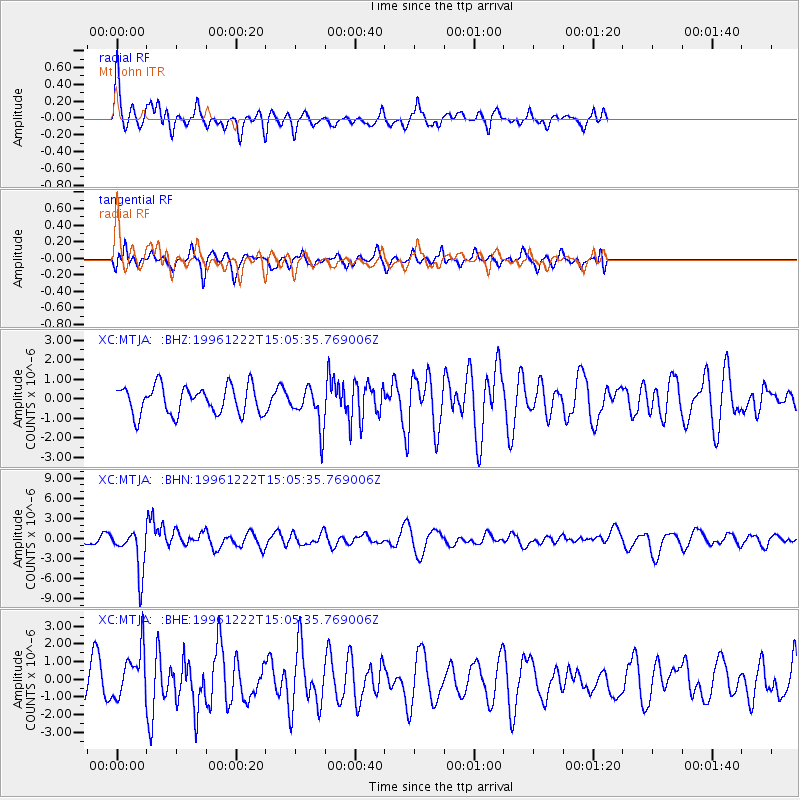
Signal To Noise
| Channel | StoN | STA | LTA |
| XC:MTJA: :BHN:19961222T15:05:35.769006Z | 4.056974 | 3.2638525E-6 | 8.045042E-7 |
| XC:MTJA: :BHE:19961222T15:05:35.769006Z | 1.1555636 | 1.3784031E-6 | 1.1928405E-6 |
| XC:MTJA: :BHZ:19961222T15:05:35.769006Z | 1.3980181 | 9.994607E-7 | 7.149125E-7 |
| Arrivals |
| Ps | |
| PpPs | |
| PsPs/PpSs | |


