You are here: Home > Network List > XC95 - Southern Alps Passive Seismic Experiment Stations List
> Station MTJA Mt John > Earthquake Result Viewer
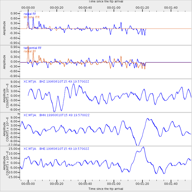
MTJA Mt John - Earthquake Result Viewer
*The percent match for this event was below the threshold and hence no stack was calculated.
| Earthquake location: |
Andreanof Islands, Aleutian Is. |
| Earthquake latitude/longitude: |
51.2/-176.8 |
| Earthquake time(UTC): |
1996/06/10 (162) 15:36:29 GMT |
| Earthquake Depth: |
33 km |
| Earthquake Magnitude: |
5.5 MB |
| Earthquake Catalog/Contributor: |
WHDF/NEIC |
|
| Network: |
XC Southern Alps Passive Seismic Experiment |
| Station: |
MTJA Mt John |
| Lat/Lon: |
43.99 S/170.46 E |
| Elevation: |
1042 m |
|
| Distance: |
95.4 deg |
| Az: |
189.227 deg |
| Baz: |
8.038 deg |
| Ray Param: |
$rayparam |
*The percent match for this event was below the threshold and hence was not used in the summary stack. |
|
| Radial Match: |
65.07874 % |
| Radial Bump: |
282 |
| Transverse Match: |
63.61471 % |
| Transverse Bump: |
385 |
| SOD ConfigId: |
4480 |
| Insert Time: |
2010-02-26 15:08:48.676 +0000 |
| GWidth: |
2.5 |
| Max Bumps: |
400 |
| Tol: |
0.001 |
|
Signal To Noise
| Channel | StoN | STA | LTA |
| XC:MTJA: :BHN:19960610T15:49:19.57002Z | 1.393745 | 2.7601995E-6 | 1.9804193E-6 |
| XC:MTJA: :BHE:19960610T15:49:19.57002Z | 0.8971213 | 4.40827E-6 | 4.913795E-6 |
| XC:MTJA: :BHZ:19960610T15:49:19.57002Z | 1.2501602 | 5.3773156E-6 | 4.301301E-6 |
| Arrivals |
| Ps | |
| PpPs | |
| PsPs/PpSs | |


