You are here: Home > Network List > XC95 - Southern Alps Passive Seismic Experiment Stations List
> Station MTJA Mt John > Earthquake Result Viewer
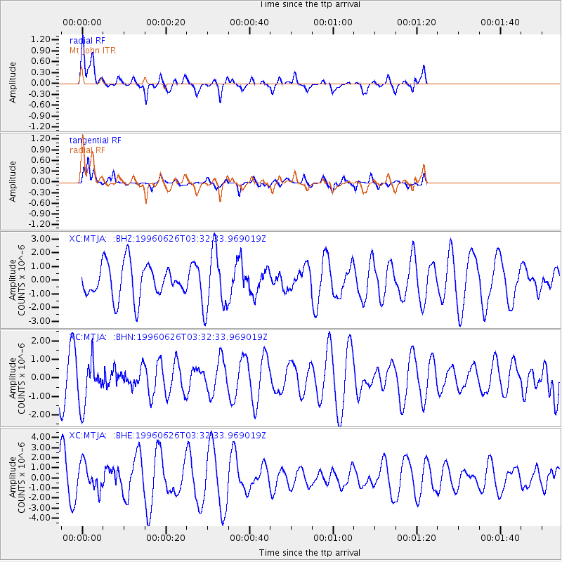
MTJA Mt John - Earthquake Result Viewer
*The percent match for this event was below the threshold and hence no stack was calculated.
| Earthquake location: |
Bonin Islands, Japan Region |
| Earthquake latitude/longitude: |
27.7/139.7 |
| Earthquake time(UTC): |
1996/06/26 (178) 03:22:03 GMT |
| Earthquake Depth: |
469 km |
| Earthquake Magnitude: |
5.5 MB, 6.3 UNKNOWN, 5.4 MB |
| Earthquake Catalog/Contributor: |
WHDF/NEIC |
|
| Network: |
XC Southern Alps Passive Seismic Experiment |
| Station: |
MTJA Mt John |
| Lat/Lon: |
43.99 S/170.46 E |
| Elevation: |
1042 m |
|
| Distance: |
76.7 deg |
| Az: |
157.737 deg |
| Baz: |
332.273 deg |
| Ray Param: |
$rayparam |
*The percent match for this event was below the threshold and hence was not used in the summary stack. |
|
| Radial Match: |
65.09853 % |
| Radial Bump: |
400 |
| Transverse Match: |
55.44176 % |
| Transverse Bump: |
363 |
| SOD ConfigId: |
4480 |
| Insert Time: |
2010-02-26 15:08:49.235 +0000 |
| GWidth: |
2.5 |
| Max Bumps: |
400 |
| Tol: |
0.001 |
|
Signal To Noise
| Channel | StoN | STA | LTA |
| XC:MTJA: :BHN:19960626T03:32:33.969019Z | 1.3066825 | 1.2148932E-6 | 9.2975404E-7 |
| XC:MTJA: :BHE:19960626T03:32:33.969019Z | 0.929333 | 1.3017237E-6 | 1.4007076E-6 |
| XC:MTJA: :BHZ:19960626T03:32:33.969019Z | 1.7832183 | 2.1839617E-6 | 1.2247303E-6 |
| Arrivals |
| Ps | |
| PpPs | |
| PsPs/PpSs | |


