You are here: Home > Network List > XC95 - Southern Alps Passive Seismic Experiment Stations List
> Station MTJA Mt John > Earthquake Result Viewer
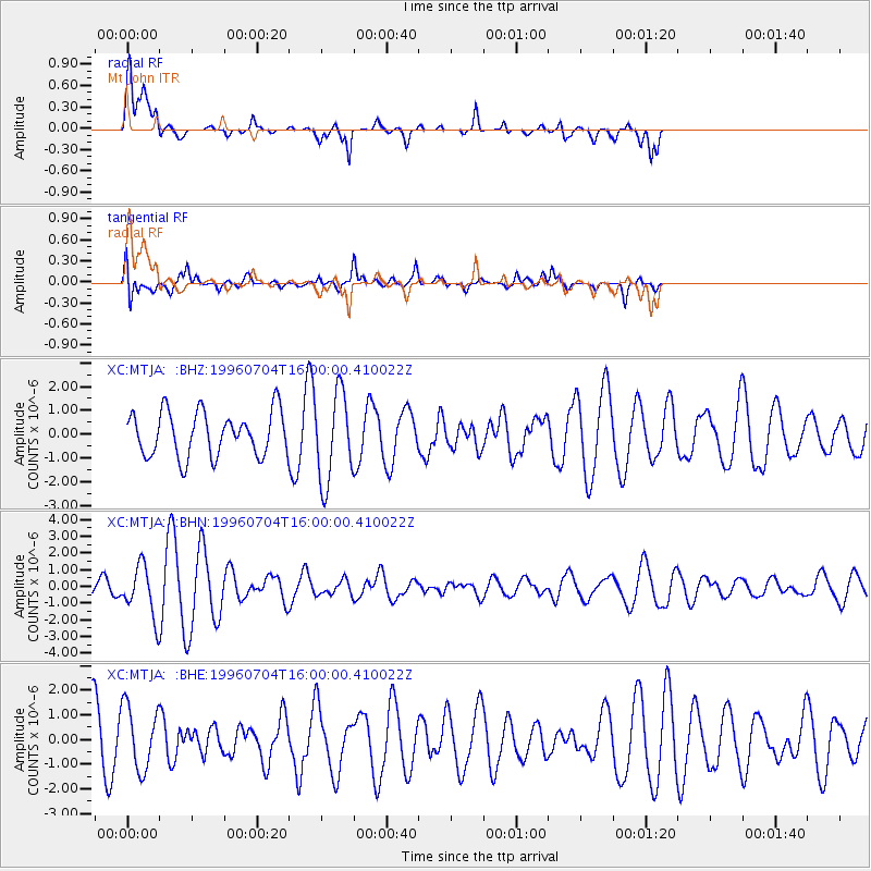
MTJA Mt John - Earthquake Result Viewer
*The percent match for this event was below the threshold and hence no stack was calculated.
| Earthquake location: |
W. Caroline Islands, Micronesia |
| Earthquake latitude/longitude: |
8.5/141.6 |
| Earthquake time(UTC): |
1996/07/04 (186) 15:50:38 GMT |
| Earthquake Depth: |
33 km |
| Earthquake Magnitude: |
5.1 MB, 5.4 MS, 6.0 UNKNOWN, 5.9 MW |
| Earthquake Catalog/Contributor: |
WHDF/NEIC |
|
| Network: |
XC Southern Alps Passive Seismic Experiment |
| Station: |
MTJA Mt John |
| Lat/Lon: |
43.99 S/170.46 E |
| Elevation: |
1042 m |
|
| Distance: |
58.4 deg |
| Az: |
155.827 deg |
| Baz: |
325.865 deg |
| Ray Param: |
$rayparam |
*The percent match for this event was below the threshold and hence was not used in the summary stack. |
|
| Radial Match: |
51.65633 % |
| Radial Bump: |
400 |
| Transverse Match: |
64.777504 % |
| Transverse Bump: |
400 |
| SOD ConfigId: |
4480 |
| Insert Time: |
2010-02-26 15:08:50.461 +0000 |
| GWidth: |
2.5 |
| Max Bumps: |
400 |
| Tol: |
0.001 |
|
Signal To Noise
| Channel | StoN | STA | LTA |
| XC:MTJA: :BHN:19960704T16:00:00.410022Z | 2.4827511 | 1.4773348E-6 | 5.950394E-7 |
| XC:MTJA: :BHE:19960704T16:00:00.410022Z | 1.4143325 | 1.2860094E-6 | 9.0926943E-7 |
| XC:MTJA: :BHZ:19960704T16:00:00.410022Z | 2.000249 | 1.865019E-6 | 9.3239345E-7 |
| Arrivals |
| Ps | |
| PpPs | |
| PsPs/PpSs | |


