You are here: Home > Network List > XC95 - Southern Alps Passive Seismic Experiment Stations List
> Station MTJA Mt John > Earthquake Result Viewer
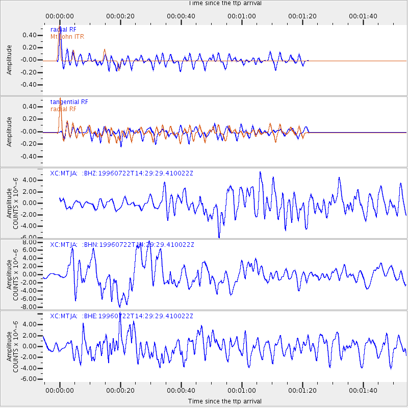
MTJA Mt John - Earthquake Result Viewer
*The percent match for this event was below the threshold and hence no stack was calculated.
| Earthquake location: |
Minahassa Peninsula, Sulawesi |
| Earthquake latitude/longitude: |
1.0/120.4 |
| Earthquake time(UTC): |
1996/07/22 (204) 14:19:35 GMT |
| Earthquake Depth: |
33 km |
| Earthquake Magnitude: |
6.0 MB, 6.9 MS, 7.0 UNKNOWN, 6.9 MW |
| Earthquake Catalog/Contributor: |
WHDF/NEIC |
|
| Network: |
XC Southern Alps Passive Seismic Experiment |
| Station: |
MTJA Mt John |
| Lat/Lon: |
43.99 S/170.46 E |
| Elevation: |
1042 m |
|
| Distance: |
63.1 deg |
| Az: |
141.687 deg |
| Baz: |
300.826 deg |
| Ray Param: |
$rayparam |
*The percent match for this event was below the threshold and hence was not used in the summary stack. |
|
| Radial Match: |
71.91759 % |
| Radial Bump: |
400 |
| Transverse Match: |
61.48495 % |
| Transverse Bump: |
400 |
| SOD ConfigId: |
4480 |
| Insert Time: |
2010-02-26 15:08:53.742 +0000 |
| GWidth: |
2.5 |
| Max Bumps: |
400 |
| Tol: |
0.001 |
|
Signal To Noise
| Channel | StoN | STA | LTA |
| XC:MTJA: :BHN:19960722T14:29:29.410022Z | 3.5725808 | 2.6428418E-6 | 7.39757E-7 |
| XC:MTJA: :BHE:19960722T14:29:29.410022Z | 0.80163264 | 8.39126E-7 | 1.0467713E-6 |
| XC:MTJA: :BHZ:19960722T14:29:29.410022Z | 2.3804855 | 1.4290997E-6 | 6.003396E-7 |
| Arrivals |
| Ps | |
| PpPs | |
| PsPs/PpSs | |


