You are here: Home > Network List > XC95 - Southern Alps Passive Seismic Experiment Stations List
> Station MTJA Mt John > Earthquake Result Viewer
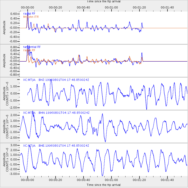
MTJA Mt John - Earthquake Result Viewer
*The percent match for this event was below the threshold and hence no stack was calculated.
| Earthquake location: |
Minahassa Peninsula, Sulawesi |
| Earthquake latitude/longitude: |
-0.0/122.9 |
| Earthquake time(UTC): |
1996/08/01 (214) 04:08:23 GMT |
| Earthquake Depth: |
149 km |
| Earthquake Magnitude: |
5.5 MB, 5.6 UNKNOWN, 5.5 MW |
| Earthquake Catalog/Contributor: |
WHDF/NEIC |
|
| Network: |
XC Southern Alps Passive Seismic Experiment |
| Station: |
MTJA Mt John |
| Lat/Lon: |
43.99 S/170.46 E |
| Elevation: |
1042 m |
|
| Distance: |
60.8 deg |
| Az: |
142.422 deg |
| Baz: |
302.345 deg |
| Ray Param: |
$rayparam |
*The percent match for this event was below the threshold and hence was not used in the summary stack. |
|
| Radial Match: |
57.9232 % |
| Radial Bump: |
390 |
| Transverse Match: |
71.508125 % |
| Transverse Bump: |
400 |
| SOD ConfigId: |
4480 |
| Insert Time: |
2010-02-26 15:08:54.285 +0000 |
| GWidth: |
2.5 |
| Max Bumps: |
400 |
| Tol: |
0.001 |
|
Signal To Noise
| Channel | StoN | STA | LTA |
| XC:MTJA: :BHN:19960801T04:17:48.850024Z | 2.7795942 | 1.6692303E-6 | 6.005302E-7 |
| XC:MTJA: :BHE:19960801T04:17:48.850024Z | 2.0621061 | 1.8732541E-6 | 9.0841786E-7 |
| XC:MTJA: :BHZ:19960801T04:17:48.850024Z | 1.1228076 | 9.598729E-7 | 8.5488625E-7 |
| Arrivals |
| Ps | |
| PpPs | |
| PsPs/PpSs | |


