You are here: Home > Network List > XC95 - Southern Alps Passive Seismic Experiment Stations List
> Station MTJA Mt John > Earthquake Result Viewer
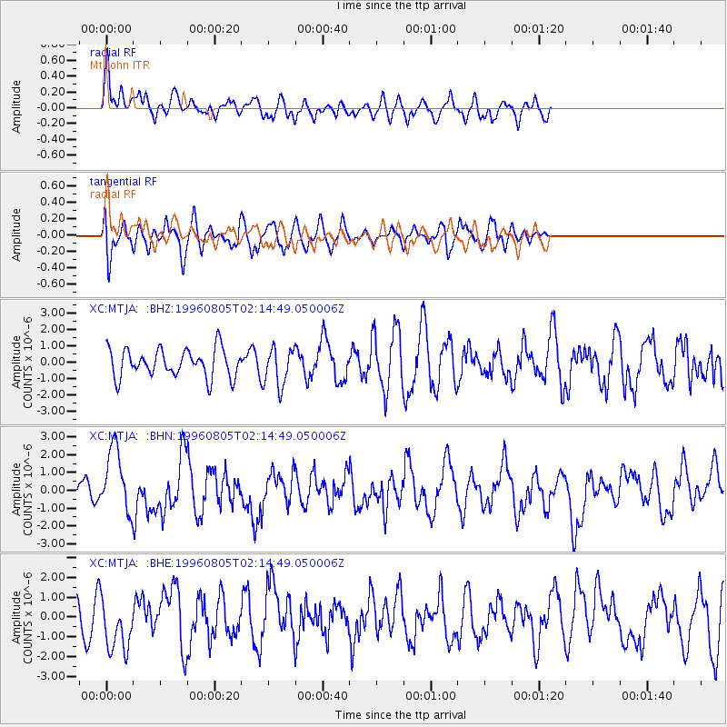
MTJA Mt John - Earthquake Result Viewer
*The percent match for this event was below the threshold and hence no stack was calculated.
| Earthquake location: |
Tonga Islands |
| Earthquake latitude/longitude: |
-15.3/-173.1 |
| Earthquake time(UTC): |
1996/08/05 (218) 02:08:58 GMT |
| Earthquake Depth: |
41 km |
| Earthquake Magnitude: |
6.0 MB, 6.7 MS, 6.7 UNKNOWN, 6.2 ME |
| Earthquake Catalog/Contributor: |
WHDF/NEIC |
|
| Network: |
XC Southern Alps Passive Seismic Experiment |
| Station: |
MTJA Mt John |
| Lat/Lon: |
43.99 S/170.46 E |
| Elevation: |
1042 m |
|
| Distance: |
31.9 deg |
| Az: |
202.73 deg |
| Baz: |
31.107 deg |
| Ray Param: |
$rayparam |
*The percent match for this event was below the threshold and hence was not used in the summary stack. |
|
| Radial Match: |
75.57064 % |
| Radial Bump: |
400 |
| Transverse Match: |
61.561646 % |
| Transverse Bump: |
400 |
| SOD ConfigId: |
4480 |
| Insert Time: |
2010-02-26 15:08:54.924 +0000 |
| GWidth: |
2.5 |
| Max Bumps: |
400 |
| Tol: |
0.001 |
|
Signal To Noise
| Channel | StoN | STA | LTA |
| XC:MTJA: :BHN:19960805T02:14:49.050006Z | 2.3956063 | 1.8299315E-6 | 7.6386993E-7 |
| XC:MTJA: :BHE:19960805T02:14:49.050006Z | 0.89631045 | 1.3469131E-6 | 1.5027306E-6 |
| XC:MTJA: :BHZ:19960805T02:14:49.050006Z | 1.3663005 | 1.1765268E-6 | 8.61104E-7 |
| Arrivals |
| Ps | |
| PpPs | |
| PsPs/PpSs | |


