You are here: Home > Network List > XC95 - Southern Alps Passive Seismic Experiment Stations List
> Station MTJA Mt John > Earthquake Result Viewer
MTJA Mt John - Earthquake Result Viewer
*The percent match for this event was below the threshold and hence no stack was calculated.
| Earthquake location: |
Samar, Philippines |
| Earthquake latitude/longitude: |
11.8/125.5 |
| Earthquake time(UTC): |
1996/10/02 (276) 09:48:01 GMT |
| Earthquake Depth: |
33 km |
| Earthquake Magnitude: |
6.0 MB, 6.4 MS, 6.4 UNKNOWN, 6.3 MW |
| Earthquake Catalog/Contributor: |
WHDF/NEIC |
|
| Network: |
XC Southern Alps Passive Seismic Experiment |
| Station: |
MTJA Mt John |
| Lat/Lon: |
43.99 S/170.46 E |
| Elevation: |
1042 m |
|
| Distance: |
68.9 deg |
| Az: |
146.846 deg |
| Baz: |
312.104 deg |
| Ray Param: |
$rayparam |
*The percent match for this event was below the threshold and hence was not used in the summary stack. |
|
| Radial Match: |
49.23088 % |
| Radial Bump: |
400 |
| Transverse Match: |
56.25072 % |
| Transverse Bump: |
353 |
| SOD ConfigId: |
4480 |
| Insert Time: |
2010-02-26 15:09:01.937 +0000 |
| GWidth: |
2.5 |
| Max Bumps: |
400 |
| Tol: |
0.001 |
|
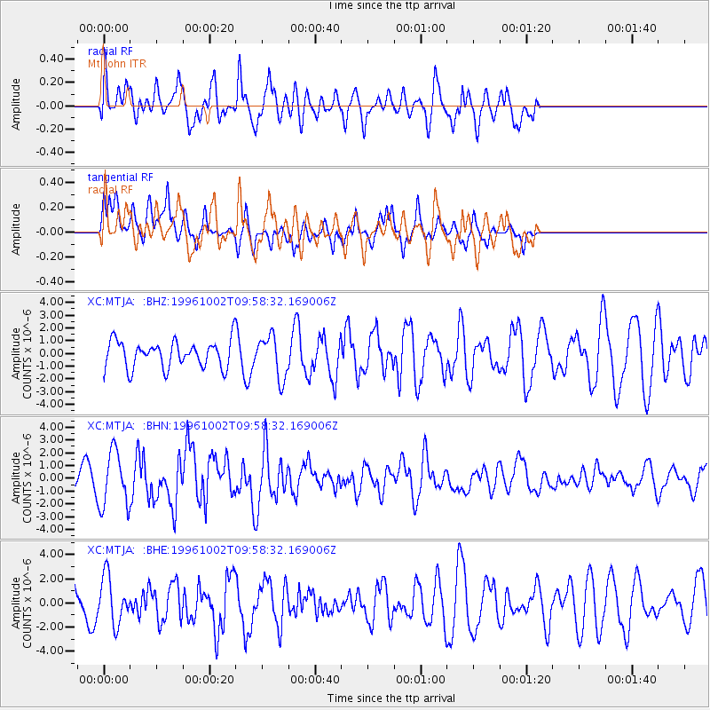
Signal To Noise
| Channel | StoN | STA | LTA |
| XC:MTJA: :BHN:19961002T09:58:32.169006Z | 3.7830873 | 2.166762E-6 | 5.727496E-7 |
| XC:MTJA: :BHE:19961002T09:58:32.169006Z | 1.0406334 | 1.974622E-6 | 1.8975192E-6 |
| XC:MTJA: :BHZ:19961002T09:58:32.169006Z | 1.6048608 | 1.6807736E-6 | 1.0473018E-6 |
| Arrivals |
| Ps | |
| PpPs | |
| PsPs/PpSs | |


