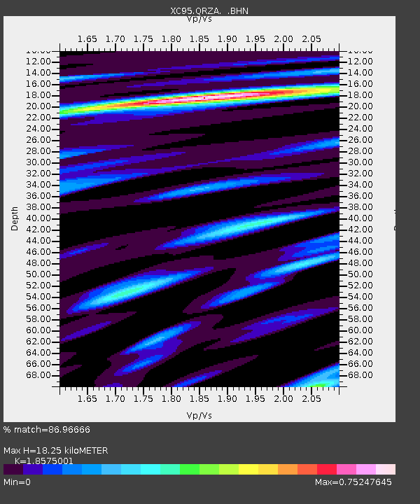
QRZA Quartz Hills - Earthquake Result Viewer

Earthquake location: Minahassa Peninsula, Sulawesi
Earthquake latitude/longitude: 1.0/120.4
Earthquake time(UTC): 1996/07/22 (204) 14:19:35 GMT
Earthquake Depth: 33 km
Earthquake Magnitude: 6.0 MB, 6.9 MS, 7.0 UNKNOWN, 6.9 MW
Earthquake Catalog/Contributor: WHDF/NEIC
Network: XC Southern Alps Passive Seismic Experiment
Station: QRZA Quartz Hills
Lat/Lon: 40.83 S/172.53 E
Elevation: 294 m
Distance: 62.9 deg
Az: 137.757 deg
Baz: 297.655 deg
Ray Param: 0.059849367
Estimated Moho Depth: 18.25 km
Estimated Crust Vp/Vs: 1.86
Assumed Crust Vp: 6.289 km/s
Estimated Crust Vs: 3.386 km/s
Estimated Crust Poisson's Ratio: 0.30
Radial Match: 86.96666 %
Radial Bump: 400
Transverse Match: 69.7355 %
Transverse Bump: 400
SOD ConfigId: 6273
Insert Time: 2010-02-26 15:09:11.709 +0000
GWidth: 2.5
Max Bumps: 400
Tol: 0.001

Signal To Noise

ChannelStoNSTALTA
XC:QRZA: :BHN:19960722T14:29:28.046008Z1.10851945.420306E-74.8896806E-7
XC:QRZA: :BHE:19960722T14:29:28.046008Z1.37216696.155112E-74.485688E-7
XC:QRZA: :BHZ:19960722T14:29:28.046008Z4.00462682.823381E-67.050298E-7
Arrivals
Ps2.6 SECOND
PpPs8.0 SECOND
PsPs/PpSs11 SECOND