You are here: Home > Network List > SP - South Carolina Earth Physics Project Stations List
> Station LGELG Lugoff-Elgin High School, Kershaw County, SC USA > Earthquake Result Viewer
LGELG Lugoff-Elgin High School, Kershaw County, SC USA - Earthquake Result Viewer
| Earthquake location: |
Queen Charlotte Islands Region |
| Earthquake latitude/longitude: |
52.6/-132.2 |
| Earthquake time(UTC): |
2001/10/12 (285) 05:02:34 GMT |
| Earthquake Depth: |
20 km |
| Earthquake Magnitude: |
5.6 MB, 5.8 MS, 6.2 MW, 6.1 MW |
| Earthquake Catalog/Contributor: |
WHDF/NEIC |
|
| Network: |
SP South Carolina Earth Physics Project |
| Station: |
LGELG Lugoff-Elgin High School, Kershaw County, SC USA |
| Lat/Lon: |
34.22 N/80.71 W |
| Elevation: |
64 m |
|
| Distance: |
40.7 deg |
| Az: |
95.973 deg |
| Baz: |
312.982 deg |
| Ray Param: |
0.0742273 |
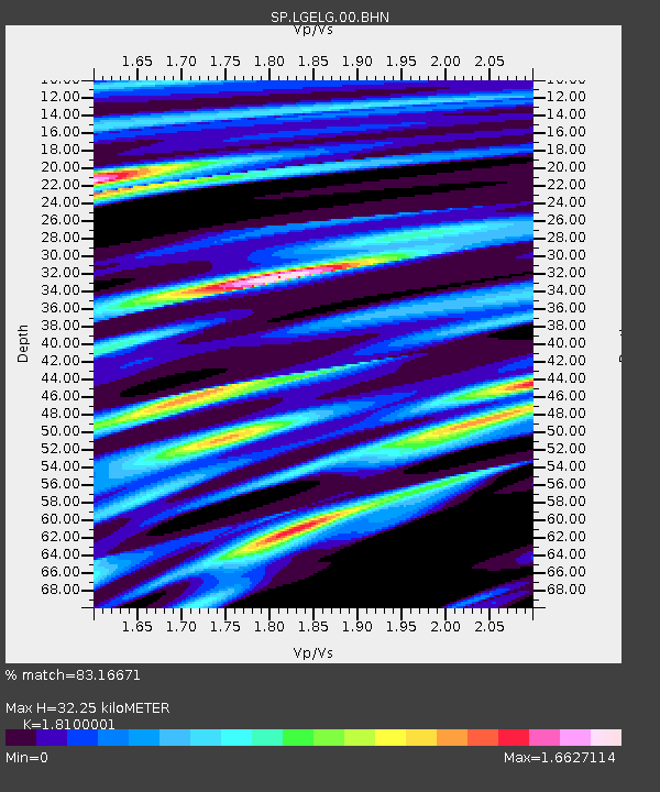
| Estimated Moho Depth: |
32.25 km |
| Estimated Crust Vp/Vs: |
1.81 |
| Assumed Crust Vp: |
6.419 km/s |
| Estimated Crust Vs: |
3.547 km/s |
| Estimated Crust Poisson's Ratio: |
0.28 |
|
| Radial Match: |
83.16671 % |
| Radial Bump: |
400 |
| Transverse Match: |
47.867725 % |
| Transverse Bump: |
400 |
| SOD ConfigId: |
2277 |
| Insert Time: |
2010-02-25 17:50:16.655 +0000 |
| GWidth: |
2.5 |
| Max Bumps: |
400 |
| Tol: |
0.001 |
|

Signal To Noise
| Channel | StoN | STA | LTA |
| SP:LGELG:00:BHN:20011012T05:09:42.286011Z | 1.884034 | 2.2608226E-7 | 1.1999904E-7 |
| SP:LGELG:00:BHE:20011012T05:09:42.286011Z | 2.2965858 | 2.715452E-7 | 1.18238646E-7 |
| SP:LGELG:00:BHZ:20011012T05:09:42.286011Z | 3.7577822 | 1.943518E-7 | 5.1719816E-8 |
| Arrivals |
| Ps | 4.4 SECOND |
| PpPs | 13 SECOND |
| PsPs/PpSs | 18 SECOND |


