
Station SP LGELG - Lugoff-Elgin High School, Kershaw County, SC USA
Network: SP - South Carolina Earth Physics Project
Nearby stations (2 deg radius)
| Station | Name | (Lat, Lon) | Start / End | Elevation |
| LGELG | Lugoff-Elgin High School, Kershaw County, SC USA | (34.22, -80.71) | 2001-09-17 / 2499-01-01 | 64 m |
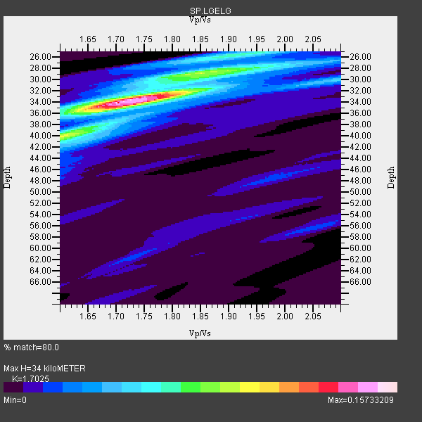
| Crust2 Type: | Q2,orogen/39km no ice, Appalachians, North Andes, 0.5 km seds. |
| Thickness Estimate: | 34 km |
| Thickness StdDev: | 0.9 km |
| Vp/Vs Estimate: | 1.70 |
| Vp/Vs StdDev: | 0.03 |
| Vs Estimate: | 3.77 km/s |
| Poisson's Ratio: | 0.24 |
| Peak Value: | 0.16 |
| Assumed Vp: | 6.419 km/s |
| Ps Weight: | 0.33333334 |
| PpPs Weight: | 0.33333334 |
| PsPs Weight: | 0.33333328 |
| Residual Complexity: | 0.578 |
| Nearby stations H: | +- |
| (2.0 deg) Vp/Vs: | +- |
5 with match > 90% ( 50.0 %) and 10 with match > 80% ( 100.0 %) out of 10.
Download stack as xyz text file.
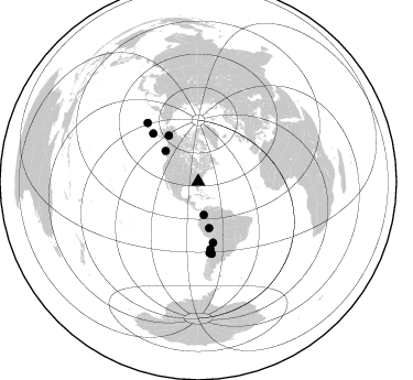
Azimuth Distribution of Events:
Prior Results for this Station
| Study | Thickness | Vp/Vs | Vp | Vs | Poissons Ratio | Extra |
| EARS | 34 km | 1.70 | 6.419 km/s | 3.77 km/s | 0.24 | |
| Crust2.0 | 39 km | 1.75 | 6.419 km/s | 3.659 km/s | 0.26 | Q2,orogen/39km no ice, Appalachians, North Andes, 0.5 km seds. |
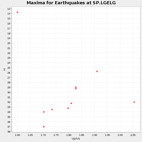
| Global Maxima | 34 km | 1.70 | 6.419 km/s | 3.77 km/s | 0.24 | amp=0.15733209 |
| Local Maxima 1 | 28 km | 1.90 | 6.419 km/s | 3.383 km/s | 0.31 | amp=0.07901931 |
| Local Maxima 2 | 40 km | 1.60 | 6.419 km/s | 4.012 km/s | 0.18 | amp=0.06385752 |
| Local Maxima 3 | 26 km | 1.89 | 6.419 km/s | 3.392 km/s | 0.31 | amp=0.047614954 |
| Local Maxima 4 | 40 km | 1.65 | 6.419 km/s | 3.885 km/s | 0.21 | amp=0.033898413 |
| Predicted Arrivals for vertical incidence (zero ray parameter) | |
| Ps | 3.72 SECOND |
| PpPs | 14.31 SECOND |
| PsPs/PpSs | 18.03 SECOND |
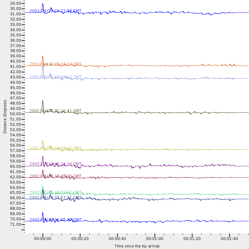
Events Processed for this Station
Download zip of receiver functions as SAC
Plot maxima for each earthquake.
Events Used in the Stack
(10 events)| Radial Match | Distance | Baz | FERegion | Time | Lat/Lon | Depth | Magnitude |
| 97.348434 | 49.7 deg | 327.301 deg | Central Alaska | 2002/11/03 22:12:41 GMT | (63.5, -147.4) | 4.9 km | 7.0 MB, 8.5 MS, 7.9 MW |
| 95.27455 | 56.8 deg | 166.212 deg | Chile-Bolivia Border Region | 2002/03/28 04:56:22 GMT | (-21.7, -68.3) | 125 km | 6.1 MB, 6.5 MW, 6.5 MW |
| 95.141304 | 43.1 deg | 166.953 deg | Western Brazil | 2002/10/12 20:09:11 GMT | (-8.3, -71.7) | 534 km | 6.5 MB, 6.9 MW, 6.9 MW |
| 92.630646 | 62.2 deg | 169.834 deg | Near Coast Of Northern Chile | 2002/04/18 16:08:36 GMT | (-27.5, -70.6) | 62 km | 6.2 MB, 6.7 MW, 6.6 MW |
| 92.06654 | 65.3 deg | 170.927 deg | Near Coast Of Central Chile | 2002/06/18 13:56:22 GMT | (-30.8, -71.1) | 54 km | 6.0 MB, 6.6 MW, 6.4 MW |
| 89.32185 | 66.3 deg | 169.273 deg | San Juan Province, Argentina | 2002/09/24 03:57:22 GMT | (-31.5, -69.2) | 120 km | 6.2 MB, 6.4 MW, 6.3 MW |
| 83.16671 | 40.7 deg | 312.982 deg | Queen Charlotte Islands Region | 2001/10/12 05:02:34 GMT | (52.6, -132.2) | 20 km | 5.6 MB, 5.8 MS, 6.2 MW, 6.1 MW |
| 82.44142 | 70.5 deg | 319.205 deg | Rat Islands, Aleutian Islands | 2003/03/17 16:36:17 GMT | (51.3, 178.0) | 33 km | 5.9 MB, 6.7 MS, 7.0 MW, 7.0 MW |
| 81.65419 | 59.9 deg | 316.805 deg | Unimak Island Region, Alaska | 2003/02/19 03:32:36 GMT | (53.6, -164.6) | 19 km | 5.8 MB, 6.6 MS, 6.6 MW, 6.6 MW |
| 80.94853 | 30.5 deg | 170.652 deg | Colombia | 2001/09/22 03:23:38 GMT | (3.9, -76.0) | 179 km | 6.0 MB, 6.0 MW, 6.0 MW |
Losers
(0 events)| Radial Match | Distance | Baz | FERegion | Time | Lat/Lon | Depth | Magnitude | Reason |
