You are here: Home > Network List > SP - South Carolina Earth Physics Project Stations List
> Station LGELG Lugoff-Elgin High School, Kershaw County, SC USA > Earthquake Result Viewer
LGELG Lugoff-Elgin High School, Kershaw County, SC USA - Earthquake Result Viewer
| Earthquake location: |
Chile-Bolivia Border Region |
| Earthquake latitude/longitude: |
-21.7/-68.3 |
| Earthquake time(UTC): |
2002/03/28 (087) 04:56:22 GMT |
| Earthquake Depth: |
125 km |
| Earthquake Magnitude: |
6.1 MB, 6.5 MW, 6.5 MW |
| Earthquake Catalog/Contributor: |
WHDF/NEIC |
|
| Network: |
SP South Carolina Earth Physics Project |
| Station: |
LGELG Lugoff-Elgin High School, Kershaw County, SC USA |
| Lat/Lon: |
34.22 N/80.71 W |
| Elevation: |
64 m |
|
| Distance: |
56.8 deg |
| Az: |
347.742 deg |
| Baz: |
166.212 deg |
| Ray Param: |
0.06351488 |
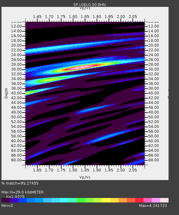
| Estimated Moho Depth: |
29.0 km |
| Estimated Crust Vp/Vs: |
1.83 |
| Assumed Crust Vp: |
6.419 km/s |
| Estimated Crust Vs: |
3.513 km/s |
| Estimated Crust Poisson's Ratio: |
0.29 |
|
| Radial Match: |
95.27455 % |
| Radial Bump: |
376 |
| Transverse Match: |
65.68563 % |
| Transverse Bump: |
400 |
| SOD ConfigId: |
2277 |
| Insert Time: |
2010-02-25 17:50:17.600 +0000 |
| GWidth: |
2.5 |
| Max Bumps: |
400 |
| Tol: |
0.001 |
|
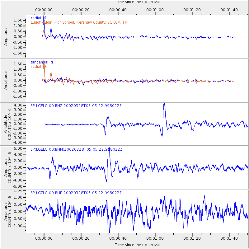
Signal To Noise
| Channel | StoN | STA | LTA |
| SP:LGELG:00:BHN:20020328T05:05:22.998022Z | 8.29354 | 1.4110991E-6 | 1.7014438E-7 |
| SP:LGELG:00:BHE:20020328T05:05:22.998022Z | 1.1448611 | 3.4475784E-7 | 3.011351E-7 |
| SP:LGELG:00:BHZ:20020328T05:05:22.998022Z | 16.255932 | 9.27661E-7 | 5.7066003E-8 |
| Arrivals |
| Ps | 3.9 SECOND |
| PpPs | 12 SECOND |
| PsPs/PpSs | 16 SECOND |


