You are here: Home > Network List > SP - South Carolina Earth Physics Project Stations List
> Station LGELG Lugoff-Elgin High School, Kershaw County, SC USA > Earthquake Result Viewer
LGELG Lugoff-Elgin High School, Kershaw County, SC USA - Earthquake Result Viewer
| Earthquake location: |
Near Coast Of Central Chile |
| Earthquake latitude/longitude: |
-30.8/-71.1 |
| Earthquake time(UTC): |
2002/06/18 (169) 13:56:22 GMT |
| Earthquake Depth: |
54 km |
| Earthquake Magnitude: |
6.0 MB, 6.6 MW, 6.4 MW |
| Earthquake Catalog/Contributor: |
WHDF/NEIC |
|
| Network: |
SP South Carolina Earth Physics Project |
| Station: |
LGELG Lugoff-Elgin High School, Kershaw County, SC USA |
| Lat/Lon: |
34.22 N/80.71 W |
| Elevation: |
64 m |
|
| Distance: |
65.3 deg |
| Az: |
351.264 deg |
| Baz: |
170.927 deg |
| Ray Param: |
0.05824148 |
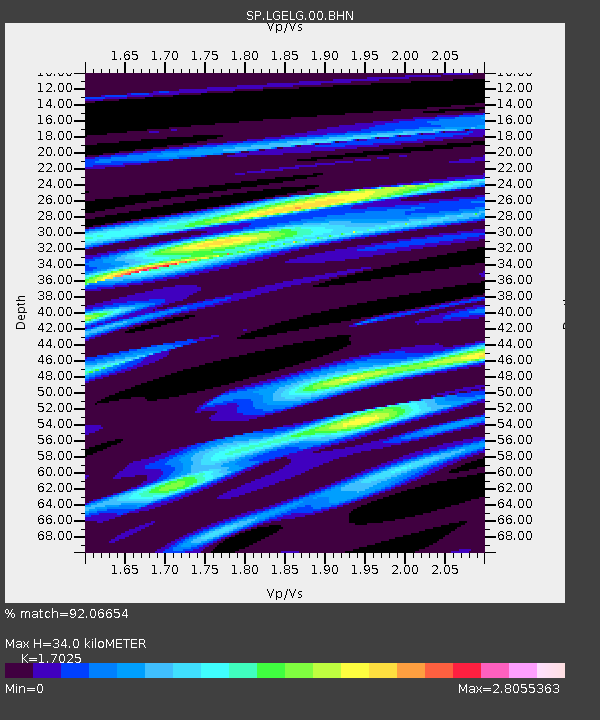
| Estimated Moho Depth: |
34.0 km |
| Estimated Crust Vp/Vs: |
1.70 |
| Assumed Crust Vp: |
6.419 km/s |
| Estimated Crust Vs: |
3.77 km/s |
| Estimated Crust Poisson's Ratio: |
0.24 |
|
| Radial Match: |
92.06654 % |
| Radial Bump: |
400 |
| Transverse Match: |
67.83185 % |
| Transverse Bump: |
400 |
| SOD ConfigId: |
2277 |
| Insert Time: |
2010-02-25 17:50:20.610 +0000 |
| GWidth: |
2.5 |
| Max Bumps: |
400 |
| Tol: |
0.001 |
|
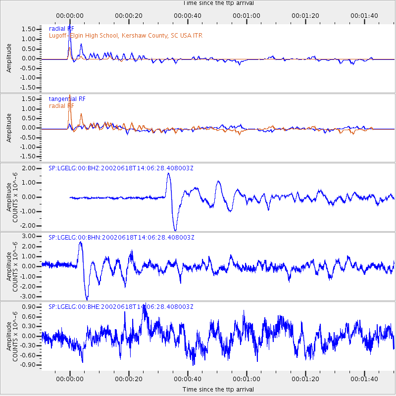
Signal To Noise
| Channel | StoN | STA | LTA |
| SP:LGELG:00:BHN:20020618T14:06:28.408003Z | 4.4707036 | 1.1646938E-6 | 2.6051688E-7 |
| SP:LGELG:00:BHE:20020618T14:06:28.408003Z | 2.314863 | 3.564183E-7 | 1.539695E-7 |
| SP:LGELG:00:BHZ:20020618T14:06:28.408003Z | 23.370169 | 7.706274E-7 | 3.2974835E-8 |
| Arrivals |
| Ps | 3.9 SECOND |
| PpPs | 14 SECOND |
| PsPs/PpSs | 18 SECOND |


