You are here: Home > Network List > SP - South Carolina Earth Physics Project Stations List
> Station LGELG Lugoff-Elgin High School, Kershaw County, SC USA > Earthquake Result Viewer
LGELG Lugoff-Elgin High School, Kershaw County, SC USA - Earthquake Result Viewer
| Earthquake location: |
Western Brazil |
| Earthquake latitude/longitude: |
-8.3/-71.7 |
| Earthquake time(UTC): |
2002/10/12 (285) 20:09:11 GMT |
| Earthquake Depth: |
534 km |
| Earthquake Magnitude: |
6.5 MB, 6.9 MW, 6.9 MW |
| Earthquake Catalog/Contributor: |
WHDF/NEIC |
|
| Network: |
SP South Carolina Earth Physics Project |
| Station: |
LGELG Lugoff-Elgin High School, Kershaw County, SC USA |
| Lat/Lon: |
34.22 N/80.71 W |
| Elevation: |
64 m |
|
| Distance: |
43.1 deg |
| Az: |
349.104 deg |
| Baz: |
166.953 deg |
| Ray Param: |
0.07013022 |
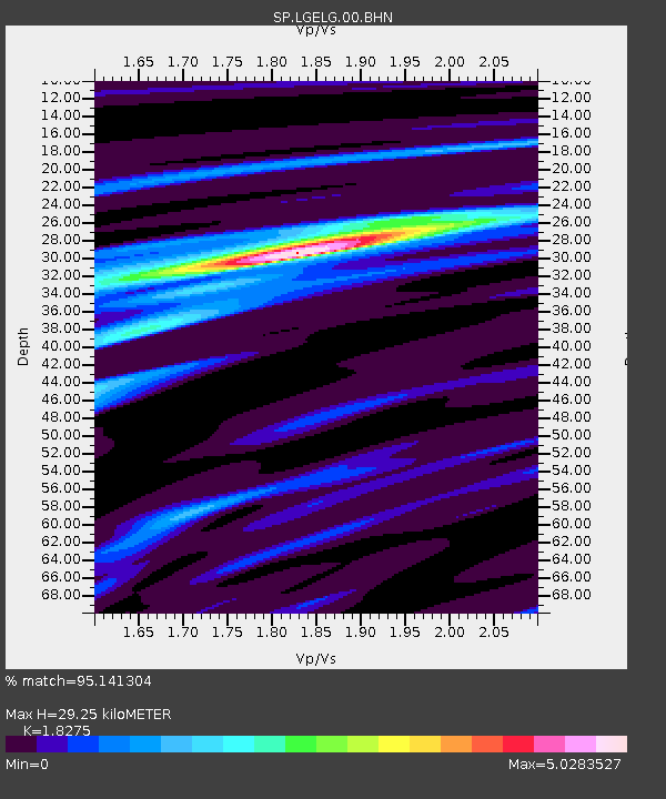
| Estimated Moho Depth: |
29.25 km |
| Estimated Crust Vp/Vs: |
1.83 |
| Assumed Crust Vp: |
6.419 km/s |
| Estimated Crust Vs: |
3.513 km/s |
| Estimated Crust Poisson's Ratio: |
0.29 |
|
| Radial Match: |
95.141304 % |
| Radial Bump: |
285 |
| Transverse Match: |
77.95678 % |
| Transverse Bump: |
400 |
| SOD ConfigId: |
2277 |
| Insert Time: |
2010-02-25 17:50:22.860 +0000 |
| GWidth: |
2.5 |
| Max Bumps: |
400 |
| Tol: |
0.001 |
|
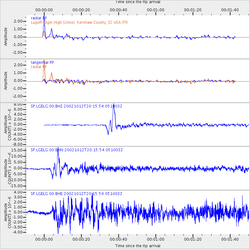
Signal To Noise
| Channel | StoN | STA | LTA |
| SP:LGELG:00:BHN:20021012T20:15:54.051003Z | 10.330765 | 2.49519E-6 | 2.4153005E-7 |
| SP:LGELG:00:BHE:20021012T20:15:54.051003Z | 1.786545 | 3.4275115E-7 | 1.9185138E-7 |
| SP:LGELG:00:BHZ:20021012T20:15:54.051003Z | 17.873379 | 1.2249649E-6 | 6.853571E-8 |
| Arrivals |
| Ps | 4.0 SECOND |
| PpPs | 12 SECOND |
| PsPs/PpSs | 16 SECOND |


