You are here: Home > Network List > SP - South Carolina Earth Physics Project Stations List
> Station LGELG Lugoff-Elgin High School, Kershaw County, SC USA > Earthquake Result Viewer
LGELG Lugoff-Elgin High School, Kershaw County, SC USA - Earthquake Result Viewer
| Earthquake location: |
Central Alaska |
| Earthquake latitude/longitude: |
63.5/-147.4 |
| Earthquake time(UTC): |
2002/11/03 (307) 22:12:41 GMT |
| Earthquake Depth: |
4.9 km |
| Earthquake Magnitude: |
7.0 MB, 8.5 MS, 7.9 MW |
| Earthquake Catalog/Contributor: |
WHDF/NEIC |
|
| Network: |
SP South Carolina Earth Physics Project |
| Station: |
LGELG Lugoff-Elgin High School, Kershaw County, SC USA |
| Lat/Lon: |
34.22 N/80.71 W |
| Elevation: |
64 m |
|
| Distance: |
49.7 deg |
| Az: |
93.129 deg |
| Baz: |
327.301 deg |
| Ray Param: |
0.0685608 |
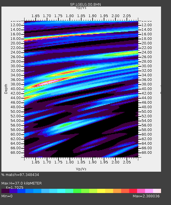
| Estimated Moho Depth: |
37.0 km |
| Estimated Crust Vp/Vs: |
1.70 |
| Assumed Crust Vp: |
6.419 km/s |
| Estimated Crust Vs: |
3.77 km/s |
| Estimated Crust Poisson's Ratio: |
0.24 |
|
| Radial Match: |
97.348434 % |
| Radial Bump: |
317 |
| Transverse Match: |
84.52731 % |
| Transverse Bump: |
400 |
| SOD ConfigId: |
2277 |
| Insert Time: |
2010-02-25 17:50:24.217 +0000 |
| GWidth: |
2.5 |
| Max Bumps: |
400 |
| Tol: |
0.001 |
|
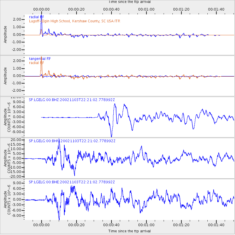
Signal To Noise
| Channel | StoN | STA | LTA |
| SP:LGELG:00:BHN:20021103T22:21:02.778992Z | 10.523112 | 1.4821342E-6 | 1.408456E-7 |
| SP:LGELG:00:BHE:20021103T22:21:02.778992Z | 6.054995 | 7.226273E-7 | 1.19344E-7 |
| SP:LGELG:00:BHZ:20021103T22:21:02.778992Z | 20.528913 | 7.944104E-7 | 3.869715E-8 |
| Arrivals |
| Ps | 4.3 SECOND |
| PpPs | 15 SECOND |
| PsPs/PpSs | 19 SECOND |


