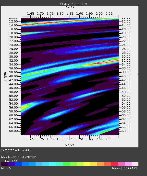
LGELG Lugoff-Elgin High School, Kershaw County, SC USA - Earthquake Result Viewer
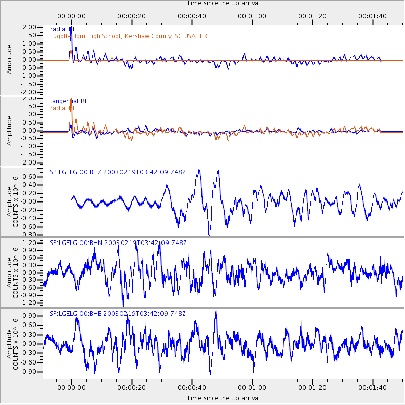
Earthquake location: Unimak Island Region, Alaska
Earthquake latitude/longitude: 53.6/-164.6
Earthquake time(UTC): 2003/02/19 (050) 03:32:36 GMT
Earthquake Depth: 19 km
Earthquake Magnitude: 5.8 MB, 6.6 MS, 6.6 MW, 6.6 MW
Earthquake Catalog/Contributor: WHDF/NEIC
Network: SP South Carolina Earth Physics Project
Station: LGELG Lugoff-Elgin High School, Kershaw County, SC USA
Lat/Lon: 34.22 N/80.71 W
Elevation: 64 m
Distance: 59.9 deg
Az: 72.305 deg
Baz: 316.805 deg
Ray Param: 0.061880637
Estimated Moho Depth: 32.0 km
Estimated Crust Vp/Vs: 2.06
Assumed Crust Vp: 6.419 km/s
Estimated Crust Vs: 3.124 km/s
Estimated Crust Poisson's Ratio: 0.34
Radial Match: 81.65419 %
Radial Bump: 400
Transverse Match: 57.336086 %
Transverse Bump: 400
SOD ConfigId: 2277
Insert Time: 2010-02-25 17:50:25.276 +0000
GWidth: 2.5
Max Bumps: 400
Tol: 0.001

Signal To Noise

ChannelStoNSTALTA
SP:LGELG:00:BHN:20030219T03:42:09.748Z1.19009823.1027727E-72.607157E-7
SP:LGELG:00:BHE:20030219T03:42:09.748Z2.0890354.447632E-72.1290367E-7
SP:LGELG:00:BHZ:20030219T03:42:09.748Z3.12759882.347748E-77.5065515E-8
Arrivals
Ps5.5 SECOND
PpPs15 SECOND
PsPs/PpSs20 SECOND