You are here: Home > Network List > XC95 - Southern Alps Passive Seismic Experiment Stations List
> Station WLZA Whitehall > Earthquake Result Viewer
WLZA Whitehall - Earthquake Result Viewer
| Earthquake location: |
Flores Sea |
| Earthquake latitude/longitude: |
-7.1/122.6 |
| Earthquake time(UTC): |
1996/06/17 (169) 11:22:18 GMT |
| Earthquake Depth: |
587 km |
| Earthquake Magnitude: |
6.6 MB, 7.9 UNKNOWN, 7.8 MW |
| Earthquake Catalog/Contributor: |
WHDF/NEIC |
|
| Network: |
XC Southern Alps Passive Seismic Experiment |
| Station: |
WLZA Whitehall |
| Lat/Lon: |
37.87 S/175.60 E |
| Elevation: |
190 m |
|
| Distance: |
56.8 deg |
| Az: |
130.916 deg |
| Baz: |
288.639 deg |
| Ray Param: |
0.06145966 |
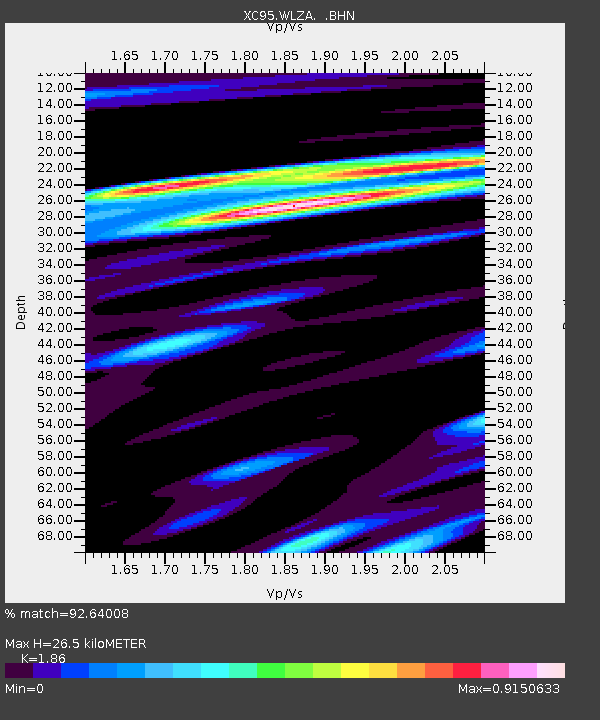
| Estimated Moho Depth: |
26.5 km |
| Estimated Crust Vp/Vs: |
1.86 |
| Assumed Crust Vp: |
6.461 km/s |
| Estimated Crust Vs: |
3.474 km/s |
| Estimated Crust Poisson's Ratio: |
0.30 |
|
| Radial Match: |
92.64008 % |
| Radial Bump: |
306 |
| Transverse Match: |
84.07939 % |
| Transverse Bump: |
400 |
| SOD ConfigId: |
6273 |
| Insert Time: |
2010-02-26 15:09:52.206 +0000 |
| GWidth: |
2.5 |
| Max Bumps: |
400 |
| Tol: |
0.001 |
|
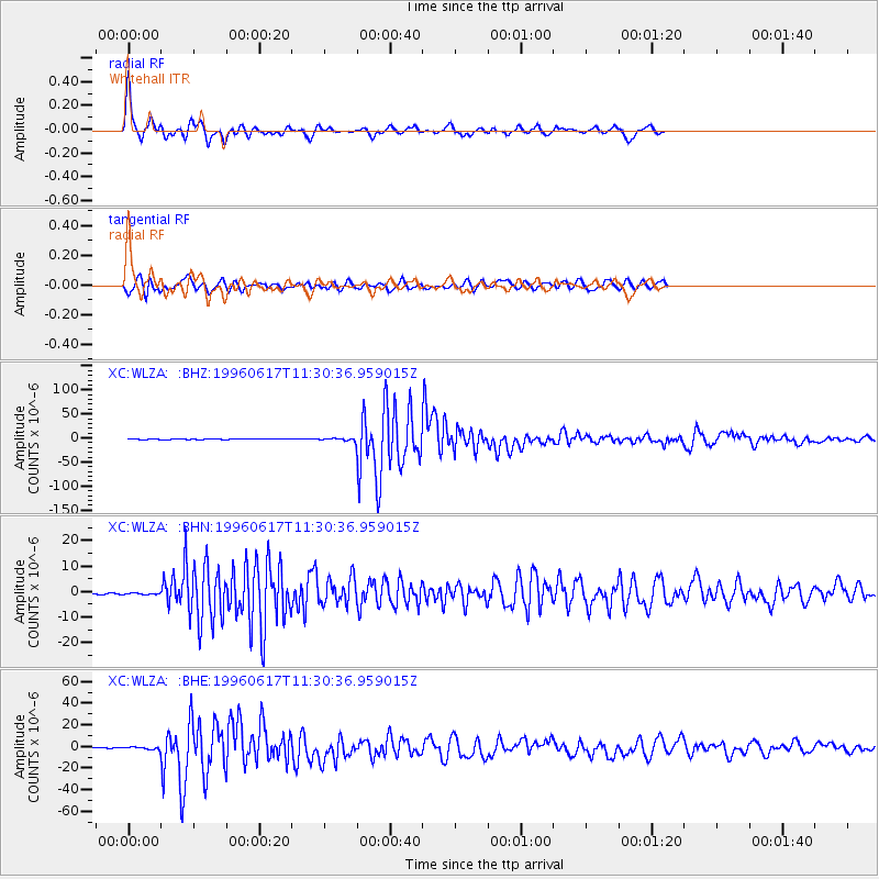
Signal To Noise
| Channel | StoN | STA | LTA |
| XC:WLZA: :BHN:19960617T11:30:36.959015Z | 1.4977205 | 3.3749498E-7 | 2.253391E-7 |
| XC:WLZA: :BHE:19960617T11:30:36.959015Z | 2.6797898 | 9.892422E-7 | 3.6914918E-7 |
| XC:WLZA: :BHZ:19960617T11:30:36.959015Z | 4.795838 | 2.2366116E-6 | 4.6636512E-7 |
| Arrivals |
| Ps | 3.7 SECOND |
| PpPs | 11 SECOND |
| PsPs/PpSs | 15 SECOND |


