
Station XC WLZA - Whitehall
Network: XC95 - Southern Alps Passive Seismic Experiment
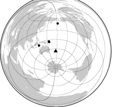
Nearby stations (2 deg radius)
| Station | Name | (Lat, Lon) | Start / End | Elevation |
| WLZA | Whitehall | (-37.87, 175.60) | 1996-04-13 / 1997-12-31 | 190 m |
| Crust2 Type: | K2,forearc, New Zealand, 0.7 km seds. |
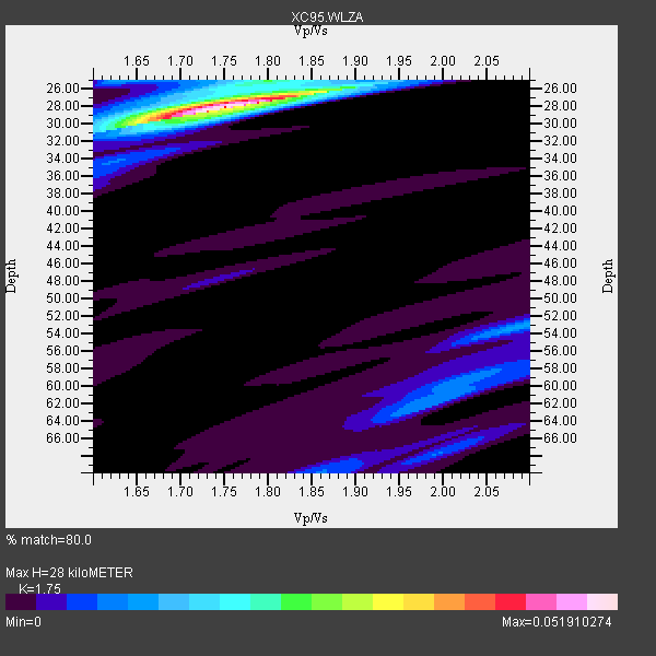
| Thickness Estimate: | 28 km |
| Thickness StdDev: | 7.9 km |
| Vp/Vs Estimate: | 1.75 |
| Vp/Vs StdDev: | 0.06 |
| Vs Estimate: | 3.692 km/s |
| Poisson's Ratio: | 0.26 |
| Peak Value: | 0.05 |
| Assumed Vp: | 6.461 km/s |
| Ps Weight: | 0.33333334 |
| PpPs Weight: | 0.33333334 |
| PsPs Weight: | 0.33333328 |
| Residual Complexity: | 0.341 |
| Nearby stations H: | 28 km +- 0.0 km |
| (2.0 deg) Vp/Vs: | 1.75 +- 0.01 |
3 with match > 90% ( 14.285714 %) and 4 with match > 80% ( 19.047619 %) out of 21.
Download stack as xyz text file.
Azimuth Distribution of Events:
Prior Results for this Station
| Study | Thickness | Vp/Vs | Vp | Vs | Poissons Ratio | Extra |
| EARS | 28 km | 1.75 | 6.461 km/s | 3.692 km/s | 0.26 | |
| Crust2.0 | 35 km | 1.76 | 6.461 km/s | 3.663 km/s | 0.26 | K2,forearc, New Zealand, 0.7 km seds. |
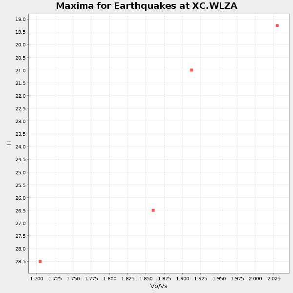
| Global Maxima | 28 km | 1.75 | 6.461 km/s | 3.692 km/s | 0.26 | amp=0.051910274 |
| Local Maxima 1 | 25 km | 1.80 | 6.461 km/s | 3.595 km/s | 0.28 | amp=0.015639748 |
| Local Maxima 2 | 53 km | 2.09 | 6.461 km/s | 3.088 km/s | 0.35 | amp=0.011916793 |
| Local Maxima 3 | 25 km | 1.62 | 6.461 km/s | 3.976 km/s | 0.20 | amp=0.011260856 |
| Local Maxima 4 | 62 km | 1.99 | 6.461 km/s | 3.251 km/s | 0.33 | amp=0.008788142 |
| Predicted Arrivals for vertical incidence (zero ray parameter) | |
| Ps | 3.25 SECOND |
| PpPs | 11.92 SECOND |
| PsPs/PpSs | 15.17 SECOND |
Events Processed for this Station
Download zip of receiver functions as SAC
Plot maxima for each earthquake.
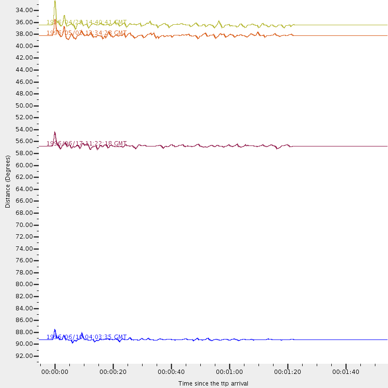
Events Used in the Stack
(4 events)| Radial Match | Distance | Baz | FERegion | Time | Lat/Lon | Depth | Magnitude |
| 97.64827 | 89.3 deg | 4.221 deg | Andreanof Islands, Aleutian Is. | 1996/06/10 04:03:35 GMT | (51.6, -177.6) | 33 km | 6.6 MB, 7.6 MS, 7.9 UNKNOWN, 7.4 MS |
| 92.64008 | 56.8 deg | 288.639 deg | Flores Sea | 1996/06/17 11:22:18 GMT | (-7.1, 122.6) | 587 km | 6.6 MB, 7.9 UNKNOWN, 7.8 MW |
| 92.26791 | 36.4 deg | 323.899 deg | Solomon Islands | 1996/04/29 14:40:41 GMT | (-6.5, 155.0) | 44 km | 6.3 MB, 7.5 MS, 7.2 UNKNOWN, 6.8 ME |
| 82.062 | 38.2 deg | 325.147 deg | Solomon Islands | 1996/05/02 13:34:28 GMT | (-4.5, 154.8) | 500 km | 5.6 MB, 6.6 UNKNOWN, 6.5 MW |
Losers
(17 events)| Radial Match | Distance | Baz | FERegion | Time | Lat/Lon | Depth | Magnitude | Reason |
| 76.062546 | 33.0 deg | 325.06 deg | Solomon Islands | 1996/06/03 10:46:00 GMT | (-9.3, 157.2) | 33 km | 5.3 MB, 6.0 MS | |
| 69.49506 | 36.3 deg | 323.888 deg | Solomon Islands | 1996/05/11 13:43:45 GMT | (-6.6, 155.0) | 33 km | 5.7 MB, 6.3 MS, 6.4 UNKNOWN, 6.3 MW | |
| 67.07717 | 63.9 deg | 293.729 deg | Minahassa Peninsula, Sulawesi | 1996/07/16 10:07:36 GMT | (1.0, 120.3) | 33 km | 6.0 MB, 6.4 MS, 6.6 UNKNOWN, 6.6 MW | |
| 65.05748 | 36.7 deg | 323.339 deg | Solomon Islands | 1996/05/02 02:32:35 GMT | (-6.4, 154.6) | 33 km | 5.3 MB, 5.9 MS, 6.0 UNKNOWN, 5.9 MW | |
| 60.916603 | 84.0 deg | 168.063 deg | South Sandwich Islands Region | 1996/05/30 03:04:37 GMT | (-56.7, -26.3) | 84 km | 5.7 MB, 6.1 UNKNOWN, 5.3 MW | |
| 58.384068 | 32.9 deg | 324.982 deg | Solomon Islands | 1996/06/03 08:15:39 GMT | (-9.3, 157.2) | 33 km | 5.6 MB, 6.0 MS, 6.1 UNKNOWN, 5.8 MS | |
| 57.61124 | 36.3 deg | 323.564 deg | Solomon Islands | 1996/05/01 09:21:24 GMT | (-6.7, 154.8) | 33 km | 5.5 MB, 5.9 MS, 6.0 UNKNOWN, 5.9 MW | |
| 54.6855 | 59.9 deg | 299.255 deg | Northern Molucca Sea | 1996/05/07 08:44:36 GMT | (1.6, 126.6) | 33 km | 5.9 MB, 5.9 MS, 6.0 UNKNOWN, 5.9 MW | |
| 53.65108 | 89.1 deg | 3.774 deg | Andreanof Islands, Aleutian Is. | 1996/08/19 04:19:16 GMT | (51.5, -178.4) | 33 km | 5.7 MB, 5.6 MS, 6.0 UNKNOWN, 5.7 ML | |
| 52.829292 | 36.2 deg | 323.569 deg | Solomon Islands | 1996/05/01 10:05:09 GMT | (-6.7, 154.9) | 33 km | 5.4 MB, 6.0 MS, 6.1 UNKNOWN, 6.0 MS | |
| 51.235188 | 67.0 deg | 326.929 deg | Mariana Islands Region | 1996/07/06 21:36:28 GMT | (22.0, 142.8) | 241 km | 5.8 MB, 6.3 UNKNOWN, 6.2 MW | |
| 50.20973 | 89.2 deg | 3.919 deg | Andreanof Islands, Aleutian Is. | 1996/06/08 23:19:15 GMT | (51.5, -178.1) | 33 km | 5.9 MB, 6.3 MS, 6.5 UNKNOWN, 6.1 MS | |
| 49.13334 | 61.9 deg | 327.085 deg | Mariana Islands | 1996/06/09 01:12:16 GMT | (17.4, 145.5) | 149 km | 6.0 MB, 5.9 MS, 6.5 UNKNOWN, 6.5 MW | |
| 48.109734 | 50.0 deg | 303.588 deg | Irian Jaya Region, Indonesia | 1996/05/11 09:35:06 GMT | (-3.3, 135.9) | 24 km | 5.7 MS, 5.4 MB, 5.9 UNKNOWN, 5.8 MW | |
| 45.744484 | 32.9 deg | 325.084 deg | Solomon Islands | 1996/06/03 10:50:10 GMT | (-9.3, 157.2) | 10 km | 5.8 MB, 6.2 MS | |
| 43.551865 | 61.8 deg | 302.549 deg | Talaud Islands, Indonesia | 1996/08/13 10:07:08 GMT | (5.0, 127.4) | 75 km | 5.7 UNKNOWN, 5.0 MS, 5.4 MB | |
| 27.595833 | 77.7 deg | 277.112 deg | Southern Sumatra, Indonesia | 1996/08/09 00:27:05 GMT | (-2.0, 99.7) | 33 km | 5.5 MS, 5.4 MB, 5.8 UNKNOWN, 5.7 MW |
