You are here: Home > Network List > LD - Lamont-Doherty Cooperative Seismographic Network Stations List
> Station LOZ Lake Ozonia, New York > Earthquake Result Viewer
LOZ Lake Ozonia, New York - Earthquake Result Viewer
| Earthquake location: |
Near Coast Of Nicaragua |
| Earthquake latitude/longitude: |
11.4/-86.7 |
| Earthquake time(UTC): |
2004/10/09 (283) 21:26:53 GMT |
| Earthquake Depth: |
35 km |
| Earthquake Magnitude: |
6.0 MB, 7.0 MS, 6.9 MW, 6.8 MW |
| Earthquake Catalog/Contributor: |
WHDF/NEIC |
|
| Network: |
LD Lamont-Doherty Cooperative Seismographic Network |
| Station: |
LOZ Lake Ozonia, New York |
| Lat/Lon: |
44.62 N/74.58 W |
| Elevation: |
440 m |
|
| Distance: |
34.7 deg |
| Az: |
15.233 deg |
| Baz: |
201.145 deg |
| Ray Param: |
0.07755495 |
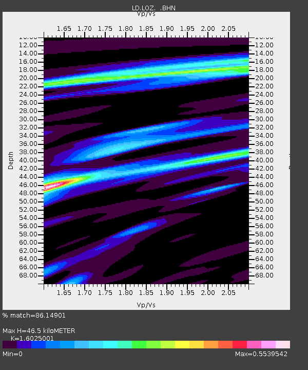
| Estimated Moho Depth: |
46.5 km |
| Estimated Crust Vp/Vs: |
1.60 |
| Assumed Crust Vp: |
6.419 km/s |
| Estimated Crust Vs: |
4.006 km/s |
| Estimated Crust Poisson's Ratio: |
0.18 |
|
| Radial Match: |
86.14901 % |
| Radial Bump: |
246 |
| Transverse Match: |
91.402245 % |
| Transverse Bump: |
226 |
| SOD ConfigId: |
2459 |
| Insert Time: |
2010-03-09 02:52:58.140 +0000 |
| GWidth: |
2.5 |
| Max Bumps: |
400 |
| Tol: |
0.001 |
|

Signal To Noise
| Channel | StoN | STA | LTA |
| LD:LOZ: :BHN:20041009T21:33:09.62399Z | 12.330743 | 1.8100752E-6 | 1.4679368E-7 |
| LD:LOZ: :BHE:20041009T21:33:09.62399Z | 15.034253 | 2.1852586E-6 | 1.4535199E-7 |
| LD:LOZ: :BHZ:20041009T21:33:09.62399Z | 11.765502 | 3.6686406E-6 | 3.1181335E-7 |
| Arrivals |
| Ps | 4.8 SECOND |
| PpPs | 17 SECOND |
| PsPs/PpSs | 22 SECOND |


