You are here: Home > Network List > XC94 - Puget Sound BB Array Stations List
> Station DOSE Dosewallips River, east > Earthquake Result Viewer
DOSE Dosewallips River, east - Earthquake Result Viewer
| Earthquake location: |
Vanuatu Islands |
| Earthquake latitude/longitude: |
-18.8/169.2 |
| Earthquake time(UTC): |
1994/02/11 (042) 21:17:31 GMT |
| Earthquake Depth: |
204 km |
| Earthquake Magnitude: |
6.3 MB, 7.0 UNKNOWN, 6.8 MW |
| Earthquake Catalog/Contributor: |
WHDF/NEIC |
|
| Network: |
XC Puget Sound BB Array |
| Station: |
DOSE Dosewallips River, east |
| Lat/Lon: |
47.71 N/122.93 W |
| Elevation: |
158 m |
|
| Distance: |
89.8 deg |
| Az: |
38.738 deg |
| Baz: |
241.371 deg |
| Ray Param: |
0.04167668 |
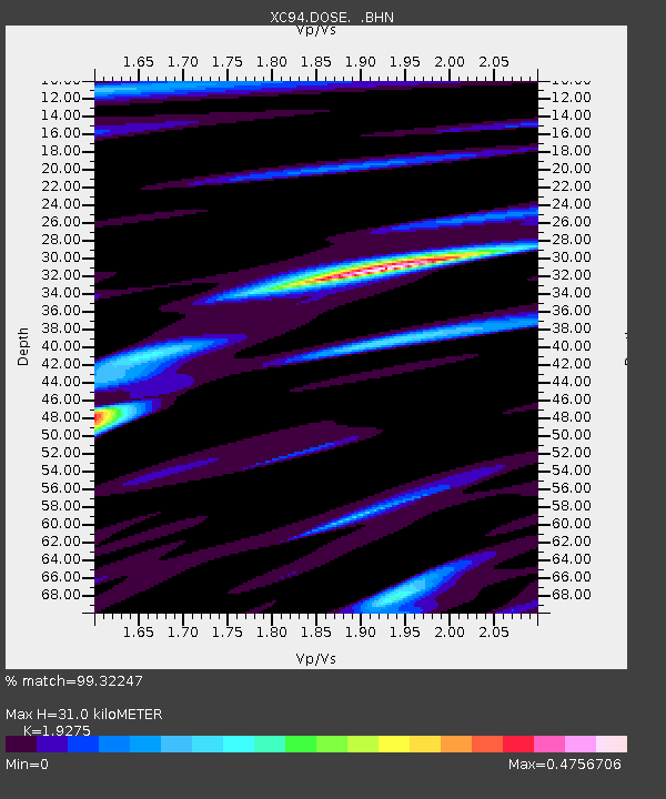
| Estimated Moho Depth: |
31.0 km |
| Estimated Crust Vp/Vs: |
1.93 |
| Assumed Crust Vp: |
6.566 km/s |
| Estimated Crust Vs: |
3.407 km/s |
| Estimated Crust Poisson's Ratio: |
0.32 |
|
| Radial Match: |
99.32247 % |
| Radial Bump: |
131 |
| Transverse Match: |
93.347496 % |
| Transverse Bump: |
400 |
| SOD ConfigId: |
16938 |
| Insert Time: |
2010-02-26 15:10:23.919 +0000 |
| GWidth: |
2.5 |
| Max Bumps: |
400 |
| Tol: |
0.001 |
|

Signal To Noise
| Channel | StoN | STA | LTA |
| XC:DOSE: :BHN:19940211T21:29:35.330017Z | 4.3079557 | 9.61941E-7 | 2.2329407E-7 |
| XC:DOSE: :BHE:19940211T21:29:35.330017Z | 24.01891 | 7.328477E-6 | 3.0511282E-7 |
| XC:DOSE: :BHZ:19940211T21:29:35.330017Z | 23.756279 | 7.3362235E-6 | 3.08812E-7 |
| Arrivals |
| Ps | 4.5 SECOND |
| PpPs | 14 SECOND |
| PsPs/PpSs | 18 SECOND |


