
Station XC DOSE - Dosewallips River, east
Network: XC94 - Puget Sound BB Array
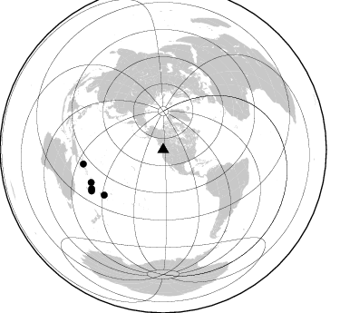
Nearby stations (2 deg radius)

| Station | Name | (Lat, Lon) | Start / End | Elevation |
| DOSE | Dosewallips River, east | (47.71, -122.93) | 1994-02-07 / 1994-12-31 | 158 m |
| Crust2 Type: | L8,thin continental arc, Cordilleras, 0.5 km seds. |
| Thickness Estimate: | 42 km |
| Thickness StdDev: | 3.8 km |
| Vp/Vs Estimate: | 1.65 |
| Vp/Vs StdDev: | 0.06 |
| Vs Estimate: | 3.973 km/s |
| Poisson's Ratio: | 0.21 |
| Peak Value: | 0.04 |
| Assumed Vp: | 6.566 km/s |
| Ps Weight: | 0.33333334 |
| PpPs Weight: | 0.33333334 |
| PsPs Weight: | 0.33333328 |
| Residual Complexity: | 0.576 |
| Nearby stations H: | +- |
| (2.0 deg) Vp/Vs: | +- |
3 with match > 90% ( 30.0 %) and 5 with match > 80% ( 50.0 %) out of 10.
Download stack as xyz text file.
Azimuth Distribution of Events:
Prior Results for this Station
| Study | Thickness | Vp/Vs | Vp | Vs | Poissons Ratio | Extra |
| EARS | 42 km | 1.65 | 6.566 km/s | 3.973 km/s | 0.21 | |
| Crust2.0 | 34 km | 1.77 | 6.566 km/s | 3.707 km/s | 0.27 | L8,thin continental arc, Cordilleras, 0.5 km seds. |
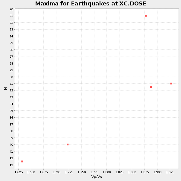
| Global Maxima | 42 km | 1.65 | 6.566 km/s | 3.973 km/s | 0.21 | amp=0.035980307 |
| Local Maxima 1 | 48 km | 1.60 | 6.566 km/s | 4.104 km/s | 0.18 | amp=0.029984467 |
| Local Maxima 2 | 49 km | 1.60 | 6.566 km/s | 4.104 km/s | 0.18 | amp=0.013494373 |
| Local Maxima 3 | 31 km | 1.92 | 6.566 km/s | 3.42 km/s | 0.31 | amp=0.010702247 |
| Local Maxima 4 | 65 km | 1.69 | 6.566 km/s | 3.885 km/s | 0.23 | amp=0.010261534 |
| Predicted Arrivals for vertical incidence (zero ray parameter) | |
| Ps | 4.12 SECOND |
| PpPs | 16.76 SECOND |
| PsPs/PpSs | 20.89 SECOND |
Events Processed for this Station
Download zip of receiver functions as SAC
Plot maxima for each earthquake.
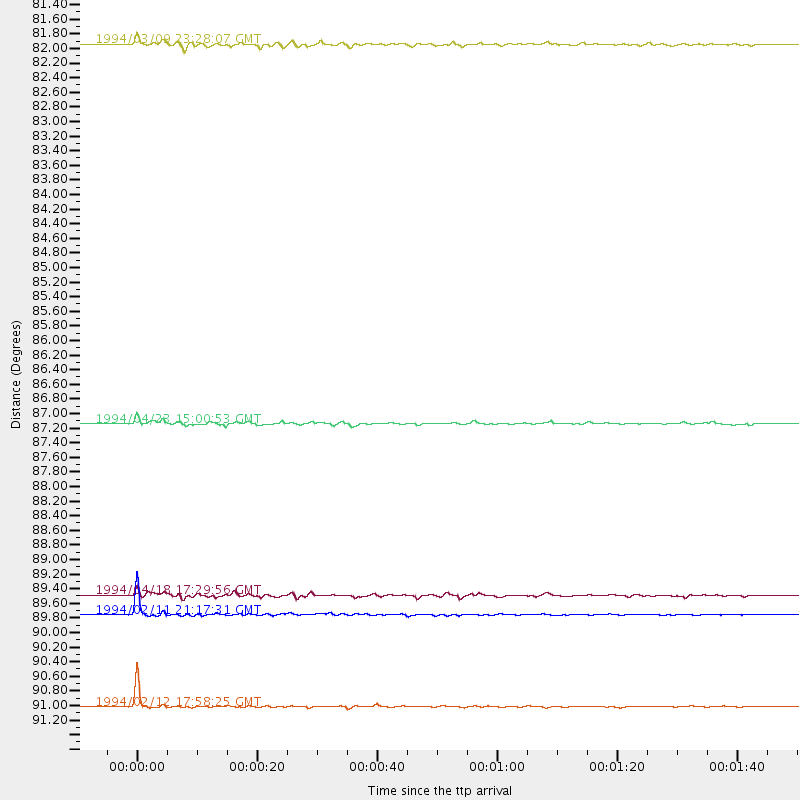
Events Used in the Stack
(5 events)| Radial Match | Distance | Baz | FERegion | Time | Lat/Lon | Depth | Magnitude |
| 99.32247 | 89.8 deg | 241.371 deg | Vanuatu Islands | 1994/02/11 21:17:31 GMT | (-18.8, 169.2) | 204 km | 6.3 MB, 7.0 UNKNOWN, 6.8 MW |
| 97.67199 | 91.0 deg | 240.125 deg | Vanuatu Islands | 1994/02/12 17:58:25 GMT | (-20.6, 169.4) | 33 km | 6.3 MB, 7.2 MS, 7.2 UNKNOWN, 7.0 MW |
| 91.45252 | 81.9 deg | 232.548 deg | Fiji Islands Region | 1994/03/09 23:28:07 GMT | (-17.8, -178.5) | 564 km | 6.6 MB, 7.6 UNKNOWN, 7.6 MW |
| 87.49848 | 87.1 deg | 245.575 deg | Vanuatu Islands | 1994/04/23 15:00:53 GMT | (-14.1, 167.5) | 11 km | 6.0 MB, 6.0 MS, 6.2 UNKNOWN, 6.2 MW |
| 86.1134 | 89.5 deg | 259.877 deg | Solomon Islands | 1994/04/18 17:29:56 GMT | (-6.5, 154.9) | 43 km | 6.6 MB, 6.7 MS, 6.8 UNKNOWN, 6.7 MW |
Losers
(5 events)| Radial Match | Distance | Baz | FERegion | Time | Lat/Lon | Depth | Magnitude | Reason |
| 91.12004 | 58.5 deg | 186.808 deg | South Pacific Ocean | 1994/02/12 04:16:26 GMT | (-10.8, -128.8) | 10 km | 6.3 MB, 6.5 MS, 6.6 UNKNOWN, 6.6 MW | |
| 78.14121 | 89.5 deg | 261.013 deg | Solomon Islands | 1994/04/21 03:51:44 GMT | (-5.7, 154.1) | 30 km | 5.8 MB, 6.6 MS, 6.7 UNKNOWN, 6.6 MW | |
| 70.009964 | 46.7 deg | 129.544 deg | Off Coast Of Central America | 1994/03/15 03:36:21 GMT | (11.2, -88.0) | 23 km | 5.8 MB, 5.5 MS, 5.4 UNKNOWN, 5.6 MD | |
| 66.74286 | 86.0 deg | 231.031 deg | Fiji Islands Region | 1994/03/31 22:40:53 GMT | (-22.0, -179.6) | 591 km | 5.9 MB, 6.5 UNKNOWN, 6.5 MW | |
| 51.42351 | 85.1 deg | 230.778 deg | Fiji Islands Region | 1994/04/18 21:39:43 GMT | (-21.4, -178.8) | 541 km | 5.5 MB |
