You are here: Home > Network List > XC94 - Puget Sound BB Array Stations List
> Station DOSW Dosewallips River, west > Earthquake Result Viewer
DOSW Dosewallips River, west - Earthquake Result Viewer
| Earthquake location: |
Vanuatu Islands |
| Earthquake latitude/longitude: |
-18.8/169.2 |
| Earthquake time(UTC): |
1994/02/11 (042) 21:17:31 GMT |
| Earthquake Depth: |
204 km |
| Earthquake Magnitude: |
6.3 MB, 7.0 UNKNOWN, 6.8 MW |
| Earthquake Catalog/Contributor: |
WHDF/NEIC |
|
| Network: |
XC Puget Sound BB Array |
| Station: |
DOSW Dosewallips River, west |
| Lat/Lon: |
47.74 N/123.02 W |
| Elevation: |
182 m |
|
| Distance: |
89.7 deg |
| Az: |
38.684 deg |
| Baz: |
241.297 deg |
| Ray Param: |
0.04168001 |
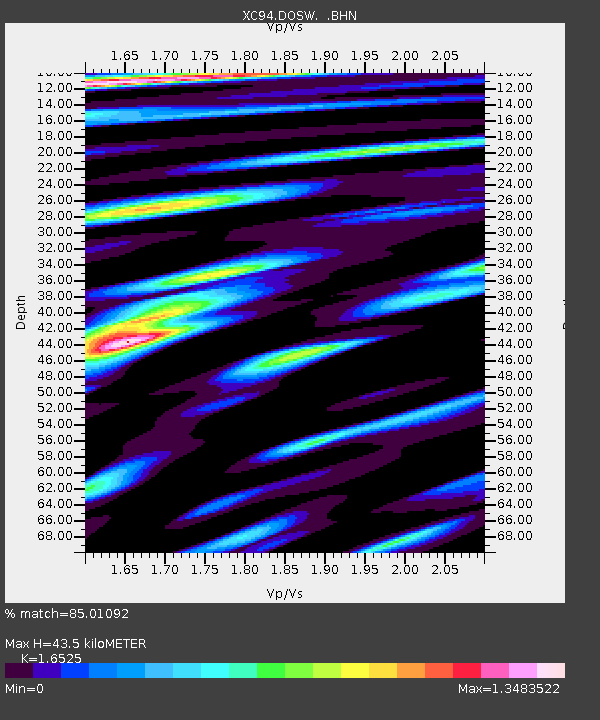
| Estimated Moho Depth: |
43.5 km |
| Estimated Crust Vp/Vs: |
1.65 |
| Assumed Crust Vp: |
6.566 km/s |
| Estimated Crust Vs: |
3.973 km/s |
| Estimated Crust Poisson's Ratio: |
0.21 |
|
| Radial Match: |
85.01092 % |
| Radial Bump: |
400 |
| Transverse Match: |
84.37481 % |
| Transverse Bump: |
400 |
| SOD ConfigId: |
16938 |
| Insert Time: |
2010-02-26 15:10:33.419 +0000 |
| GWidth: |
2.5 |
| Max Bumps: |
400 |
| Tol: |
0.001 |
|
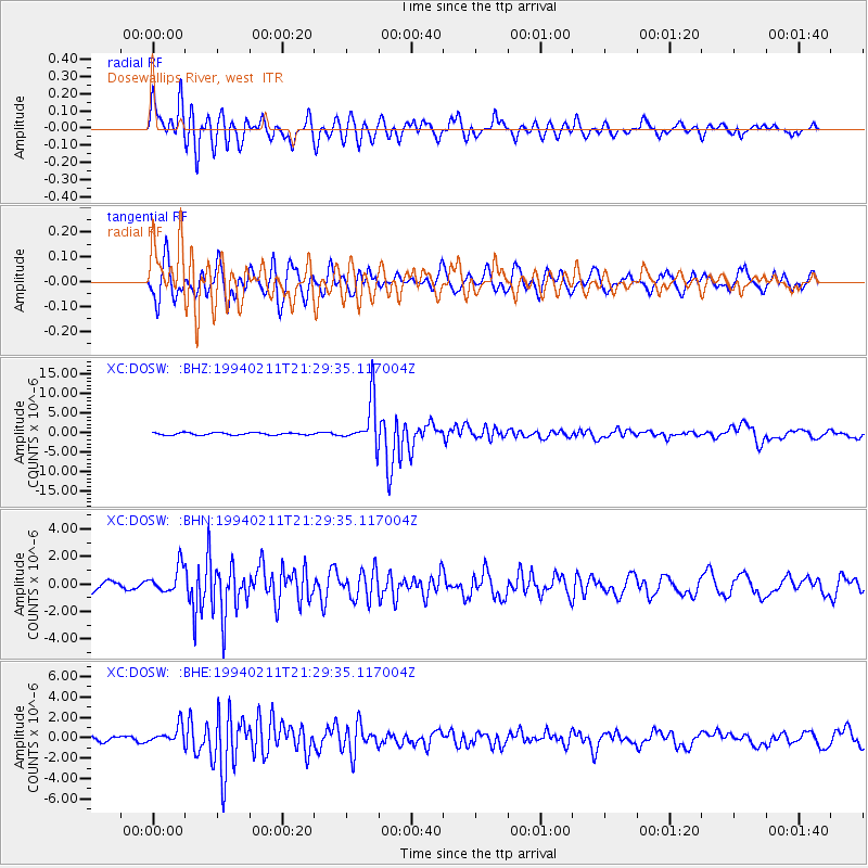
Signal To Noise
| Channel | StoN | STA | LTA |
| XC:DOSW: :BHN:19940211T21:29:35.117004Z | 3.1076574 | 9.649152E-7 | 3.1049598E-7 |
| XC:DOSW: :BHE:19940211T21:29:35.117004Z | 2.517845 | 8.706358E-7 | 3.457861E-7 |
| XC:DOSW: :BHZ:19940211T21:29:35.117004Z | 19.45453 | 5.8193273E-6 | 2.9912454E-7 |
| Arrivals |
| Ps | 4.4 SECOND |
| PpPs | 17 SECOND |
| PsPs/PpSs | 22 SECOND |


