
Station XC DOSW - Dosewallips River, west
Network: XC94 - Puget Sound BB Array
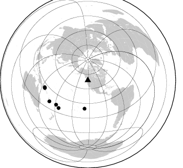
Nearby stations (2 deg radius)
| Station | Name | (Lat, Lon) | Start / End | Elevation |
| DOSW | Dosewallips River, west | (47.74, -123.02) | 1994-02-03 / 1994-12-31 | 182 m |
| Crust2 Type: | L8,thin continental arc, Cordilleras, 0.5 km seds. |
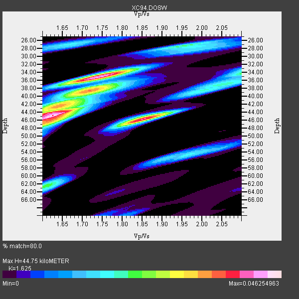
| Thickness Estimate: | 45 km |
| Thickness StdDev: | 3.6 km |
| Vp/Vs Estimate: | 1.62 |
| Vp/Vs StdDev: | 0.08 |
| Vs Estimate: | 4.041 km/s |
| Poisson's Ratio: | 0.20 |
| Peak Value: | 0.05 |
| Assumed Vp: | 6.566 km/s |
| Ps Weight: | 0.33333334 |
| PpPs Weight: | 0.33333334 |
| PsPs Weight: | 0.33333328 |
| Residual Complexity: | 0.816 |
| Nearby stations H: | +- |
| (2.0 deg) Vp/Vs: | +- |
1 with match > 90% ( 7.142857 %) and 6 with match > 80% ( 42.857143 %) out of 14.
Download stack as xyz text file.
Azimuth Distribution of Events:
Prior Results for this Station
| Study | Thickness | Vp/Vs | Vp | Vs | Poissons Ratio | Extra |
| EARS | 45 km | 1.62 | 6.566 km/s | 4.041 km/s | 0.20 | |
| Crust2.0 | 34 km | 1.77 | 6.566 km/s | 3.707 km/s | 0.27 | L8,thin continental arc, Cordilleras, 0.5 km seds. |
| Global Maxima | 45 km | 1.62 | 6.566 km/s | 4.041 km/s | 0.20 | amp=0.046254963 |
| Local Maxima 1 | 35 km | 1.74 | 6.566 km/s | 3.768 km/s | 0.25 | amp=0.042881437 |
| Local Maxima 2 | 46 km | 1.85 | 6.566 km/s | 3.554 km/s | 0.29 | amp=0.03965511 |
| Local Maxima 3 | 42 km | 1.65 | 6.566 km/s | 3.973 km/s | 0.21 | amp=0.025784703 |
| Local Maxima 4 | 62 km | 1.61 | 6.566 km/s | 4.072 km/s | 0.19 | amp=0.02116862 |
| Predicted Arrivals for vertical incidence (zero ray parameter) | |
| Ps | 4.26 SECOND |
| PpPs | 17.89 SECOND |
| PsPs/PpSs | 22.15 SECOND |
Events Processed for this Station
Download zip of receiver functions as SAC
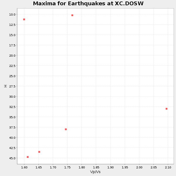
Plot maxima for each earthquake.
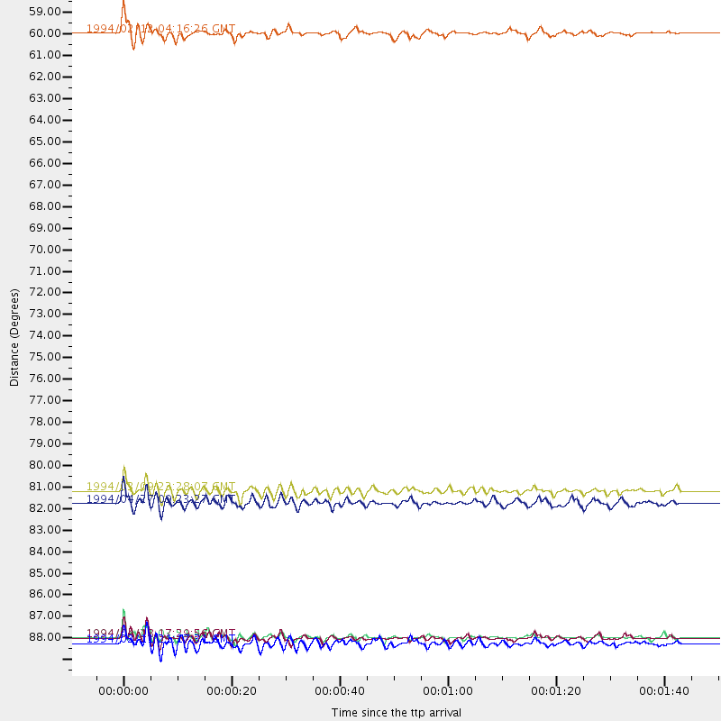
Events Used in the Stack
(6 events)| Radial Match | Distance | Baz | FERegion | Time | Lat/Lon | Depth | Magnitude |
| 94.567 | 81.9 deg | 232.467 deg | Fiji Islands Region | 1994/03/09 23:28:07 GMT | (-17.8, -178.5) | 564 km | 6.6 MB, 7.6 UNKNOWN, 7.6 MW |
| 87.99784 | 89.4 deg | 259.804 deg | Solomon Islands | 1994/04/18 17:29:56 GMT | (-6.5, 154.9) | 43 km | 6.6 MB, 6.7 MS, 6.8 UNKNOWN, 6.7 MW |
| 85.97761 | 58.5 deg | 186.693 deg | South Pacific Ocean | 1994/02/12 04:16:26 GMT | (-10.8, -128.8) | 10 km | 6.3 MB, 6.5 MS, 6.6 UNKNOWN, 6.6 MW |
| 85.01092 | 89.7 deg | 241.297 deg | Vanuatu Islands | 1994/02/11 21:17:31 GMT | (-18.8, 169.2) | 204 km | 6.3 MB, 7.0 UNKNOWN, 6.8 MW |
| 84.65654 | 89.4 deg | 260.939 deg | Solomon Islands | 1994/04/21 03:51:44 GMT | (-5.7, 154.1) | 30 km | 5.8 MB, 6.6 MS, 6.7 UNKNOWN, 6.6 MW |
| 82.40272 | 82.5 deg | 226.613 deg | Tonga Islands | 1994/04/27 09:23:27 GMT | (-21.5, -173.7) | 35 km | 6.2 MB, 6.1 MS, 6.0 UNKNOWN, 6.4 MW |
Losers
(8 events)| Radial Match | Distance | Baz | FERegion | Time | Lat/Lon | Depth | Magnitude | Reason |
| 77.70897 | 87.1 deg | 245.5 deg | Vanuatu Islands | 1994/04/23 15:00:53 GMT | (-14.1, 167.5) | 11 km | 6.0 MB, 6.0 MS, 6.2 UNKNOWN, 6.2 MW | |
| 75.56941 | 87.9 deg | 301.991 deg | Southeast Of Taiwan | 1994/04/13 04:00:51 GMT | (22.7, 123.6) | 36 km | 5.7 MB, 5.6 MS, 5.8 UNKNOWN | |
| 70.96982 | 91.0 deg | 240.052 deg | Vanuatu Islands | 1994/02/12 17:58:25 GMT | (-20.6, 169.4) | 33 km | 6.3 MB, 7.2 MS, 7.2 UNKNOWN, 7.0 MW | |
| 68.95142 | 46.8 deg | 129.449 deg | Off Coast Of Central America | 1994/03/15 03:36:21 GMT | (11.2, -88.0) | 23 km | 5.8 MB, 5.5 MS, 5.4 UNKNOWN, 5.6 MD | |
| 63.068356 | 85.1 deg | 230.7 deg | Fiji Islands Region | 1994/04/18 21:39:43 GMT | (-21.4, -178.8) | 541 km | 5.5 MB | |
| 61.945354 | 85.9 deg | 230.953 deg | Fiji Islands Region | 1994/03/31 22:40:53 GMT | (-22.0, -179.6) | 591 km | 5.9 MB, 6.5 UNKNOWN, 6.5 MW | |
| 59.9503 | 48.2 deg | 305.688 deg | Near East Coast Of Kamchatka | 1994/02/14 11:14:25 GMT | (51.9, 159.0) | 33 km | 5.7 MB, 5.4 MS, 5.1 UNKNOWN | |
| 47.235714 | 77.2 deg | 229.355 deg | Tonga Islands | 1994/04/04 01:37:03 GMT | (-15.5, -173.2) | 33 km | 5.8 MB, 5.5 MS |
