You are here: Home > Network List > XC94 - Puget Sound BB Array Stations List
> Station DOSW Dosewallips River, west > Earthquake Result Viewer
DOSW Dosewallips River, west - Earthquake Result Viewer
| Earthquake location: |
Solomon Islands |
| Earthquake latitude/longitude: |
-6.5/154.9 |
| Earthquake time(UTC): |
1994/04/18 (108) 17:29:56 GMT |
| Earthquake Depth: |
43 km |
| Earthquake Magnitude: |
6.6 MB, 6.7 MS, 6.8 UNKNOWN, 6.7 MW |
| Earthquake Catalog/Contributor: |
WHDF/NEIC |
|
| Network: |
XC Puget Sound BB Array |
| Station: |
DOSW Dosewallips River, west |
| Lat/Lon: |
47.74 N/123.02 W |
| Elevation: |
182 m |
|
| Distance: |
89.4 deg |
| Az: |
41.955 deg |
| Baz: |
259.804 deg |
| Ray Param: |
0.041789226 |
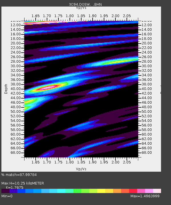
| Estimated Moho Depth: |
10.25 km |
| Estimated Crust Vp/Vs: |
1.77 |
| Assumed Crust Vp: |
6.566 km/s |
| Estimated Crust Vs: |
3.715 km/s |
| Estimated Crust Poisson's Ratio: |
0.26 |
|
| Radial Match: |
87.99784 % |
| Radial Bump: |
400 |
| Transverse Match: |
81.83015 % |
| Transverse Bump: |
400 |
| SOD ConfigId: |
16938 |
| Insert Time: |
2010-02-26 15:10:36.464 +0000 |
| GWidth: |
2.5 |
| Max Bumps: |
400 |
| Tol: |
0.001 |
|

Signal To Noise
| Channel | StoN | STA | LTA |
| XC:DOSW: :BHN:19940418T17:42:17.404004Z | 0.7222061 | 7.858495E-8 | 1.0881235E-7 |
| XC:DOSW: :BHE:19940418T17:42:17.404004Z | 0.7629086 | 1.15792034E-7 | 1.5177707E-7 |
| XC:DOSW: :BHZ:19940418T17:42:17.404004Z | 3.814776 | 4.5326968E-7 | 1.1881948E-7 |
| Arrivals |
| Ps | 1.2 SECOND |
| PpPs | 4.2 SECOND |
| PsPs/PpSs | 5.5 SECOND |


