You are here: Home > Network List > SP - South Carolina Earth Physics Project Stations List
> Station MYRTL North Myrtle Beach High School, Horry County, SC USA > Earthquake Result Viewer
MYRTL North Myrtle Beach High School, Horry County, SC USA - Earthquake Result Viewer
| Earthquake location: |
Colombia |
| Earthquake latitude/longitude: |
3.9/-76.0 |
| Earthquake time(UTC): |
2001/09/22 (265) 03:23:38 GMT |
| Earthquake Depth: |
179 km |
| Earthquake Magnitude: |
6.0 MB, 6.0 MW, 6.0 MW |
| Earthquake Catalog/Contributor: |
WHDF/NEIC |
|
| Network: |
SP South Carolina Earth Physics Project |
| Station: |
MYRTL North Myrtle Beach High School, Horry County, SC USA |
| Lat/Lon: |
33.86 N/78.67 W |
| Elevation: |
23 m |
|
| Distance: |
29.9 deg |
| Az: |
355.496 deg |
| Baz: |
174.597 deg |
| Ray Param: |
0.07913238 |
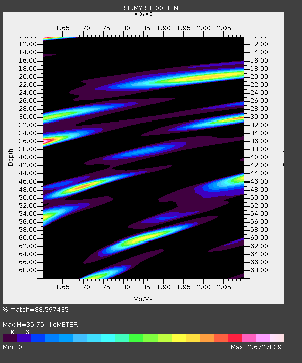
| Estimated Moho Depth: |
35.75 km |
| Estimated Crust Vp/Vs: |
1.60 |
| Assumed Crust Vp: |
6.24 km/s |
| Estimated Crust Vs: |
3.9 km/s |
| Estimated Crust Poisson's Ratio: |
0.18 |
|
| Radial Match: |
88.597435 % |
| Radial Bump: |
400 |
| Transverse Match: |
66.17389 % |
| Transverse Bump: |
400 |
| SOD ConfigId: |
2277 |
| Insert Time: |
2010-02-25 17:50:29.332 +0000 |
| GWidth: |
2.5 |
| Max Bumps: |
400 |
| Tol: |
0.001 |
|

Signal To Noise
| Channel | StoN | STA | LTA |
| SP:MYRTL:00:BHN:20010922T03:28:59.346007Z | 3.586814 | 7.08604E-7 | 1.9755805E-7 |
| SP:MYRTL:00:BHE:20010922T03:28:59.346007Z | 1.7155015 | 3.985011E-7 | 2.3229423E-7 |
| SP:MYRTL:00:BHZ:20010922T03:28:59.346007Z | 11.655074 | 9.598647E-7 | 8.2355946E-8 |
| Arrivals |
| Ps | 3.7 SECOND |
| PpPs | 14 SECOND |
| PsPs/PpSs | 17 SECOND |


