
Station SP MYRTL - North Myrtle Beach High School, Horry County, SC USA
Network: SP - South Carolina Earth Physics Project
Nearby stations (2 deg radius)
| Station | Name | (Lat, Lon) | Start / End | Elevation |
| MYRTL | North Myrtle Beach High School, Horry County, SC USA | (33.86, -78.67) | 2001-09-11 / 2003-06-19 | 23 m |
| Crust2 Type: | C2,continental shelf, 1 km seds. |
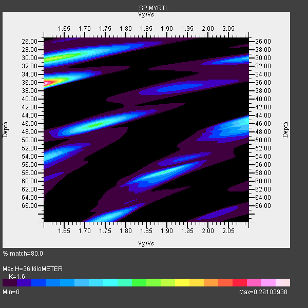
| Thickness Estimate: | 36 km |
| Thickness StdDev: | 8.9 km |
| Vp/Vs Estimate: | 1.60 |
| Vp/Vs StdDev: | 0.13 |
| Vs Estimate: | 3.9 km/s |
| Poisson's Ratio: | 0.18 |
| Peak Value: | 0.29 |
| Assumed Vp: | 6.24 km/s |
| Ps Weight: | 0.33333334 |
| PpPs Weight: | 0.33333334 |
| PsPs Weight: | 0.33333328 |
| Residual Complexity: | 0.842 |
| Nearby stations H: | +- |
| (2.0 deg) Vp/Vs: | +- |
1 with match > 90% ( 50.0 %) and 2 with match > 80% ( 100.0 %) out of 2.
Download stack as xyz text file.
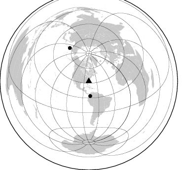
Azimuth Distribution of Events:
Prior Results for this Station
| Study | Thickness | Vp/Vs | Vp | Vs | Poissons Ratio | Extra |
| EARS | 36 km | 1.60 | 6.24 km/s | 3.9 km/s | 0.18 | |
| Crust2.0 | 30 km | 1.80 | 6.24 km/s | 3.467 km/s | 0.28 | C2,continental shelf, 1 km seds. |
| Global Maxima | 36 km | 1.60 | 6.24 km/s | 3.9 km/s | 0.18 | amp=0.29103938 |
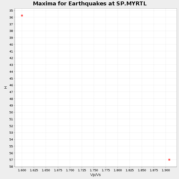
| Local Maxima 1 | 30 km | 1.62 | 6.24 km/s | 3.846 km/s | 0.19 | amp=0.1628799 |
| Local Maxima 2 | 46 km | 1.72 | 6.24 km/s | 3.623 km/s | 0.25 | amp=0.13866536 |
| Local Maxima 3 | 58 km | 1.89 | 6.24 km/s | 3.306 km/s | 0.30 | amp=0.123985335 |
| Local Maxima 4 | 45 km | 2.10 | 6.24 km/s | 2.975 km/s | 0.35 | amp=0.09607485 |
| Predicted Arrivals for vertical incidence (zero ray parameter) | |
| Ps | 3.46 SECOND |
| PpPs | 15.00 SECOND |
| PsPs/PpSs | 18.46 SECOND |
Events Processed for this Station
Download zip of receiver functions as SAC
Plot maxima for each earthquake.
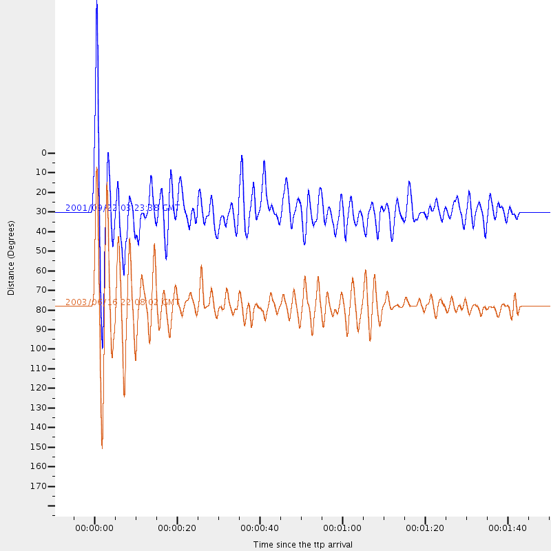
Events Used in the Stack
(2 events)| Radial Match | Distance | Baz | FERegion | Time | Lat/Lon | Depth | Magnitude |
| 91.46388 | 77.9 deg | 330.187 deg | Kamchatka Peninsula, Russia | 2003/06/16 22:08:02 GMT | (55.5, 160.0) | 175 km | 6.3 MB, 6.9 MW, 6.9 MW |
| 88.597435 | 29.9 deg | 174.597 deg | Colombia | 2001/09/22 03:23:38 GMT | (3.9, -76.0) | 179 km | 6.0 MB, 6.0 MW, 6.0 MW |
Losers
(0 events)| Radial Match | Distance | Baz | FERegion | Time | Lat/Lon | Depth | Magnitude | Reason |
