You are here: Home > Network List > XC94 - Puget Sound BB Array Stations List
> Station DOSW Dosewallips River, west > Earthquake Result Viewer
DOSW Dosewallips River, west - Earthquake Result Viewer
| Earthquake location: |
Solomon Islands |
| Earthquake latitude/longitude: |
-5.7/154.1 |
| Earthquake time(UTC): |
1994/04/21 (111) 03:51:44 GMT |
| Earthquake Depth: |
30 km |
| Earthquake Magnitude: |
5.8 MB, 6.6 MS, 6.7 UNKNOWN, 6.6 MW |
| Earthquake Catalog/Contributor: |
WHDF/NEIC |
|
| Network: |
XC Puget Sound BB Array |
| Station: |
DOSW Dosewallips River, west |
| Lat/Lon: |
47.74 N/123.02 W |
| Elevation: |
182 m |
|
| Distance: |
89.4 deg |
| Az: |
42.055 deg |
| Baz: |
260.939 deg |
| Ray Param: |
0.041835245 |
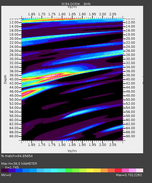
| Estimated Moho Depth: |
38.0 km |
| Estimated Crust Vp/Vs: |
1.75 |
| Assumed Crust Vp: |
6.566 km/s |
| Estimated Crust Vs: |
3.763 km/s |
| Estimated Crust Poisson's Ratio: |
0.26 |
|
| Radial Match: |
84.65654 % |
| Radial Bump: |
400 |
| Transverse Match: |
73.77887 % |
| Transverse Bump: |
400 |
| SOD ConfigId: |
16938 |
| Insert Time: |
2010-02-26 15:10:37.324 +0000 |
| GWidth: |
2.5 |
| Max Bumps: |
400 |
| Tol: |
0.001 |
|

Signal To Noise
| Channel | StoN | STA | LTA |
| XC:DOSW: :BHN:19940421T04:04:07.304028Z | 0.77775484 | 5.4455256E-8 | 7.0015965E-8 |
| XC:DOSW: :BHE:19940421T04:04:07.304028Z | 1.7950503 | 1.17562315E-7 | 6.549249E-8 |
| XC:DOSW: :BHZ:19940421T04:04:07.304028Z | 3.5514755 | 2.9985523E-7 | 8.443117E-8 |
| Arrivals |
| Ps | 4.4 SECOND |
| PpPs | 16 SECOND |
| PsPs/PpSs | 20 SECOND |


