You are here: Home > Network List > XC94 - Puget Sound BB Array Stations List
> Station DOSW Dosewallips River, west > Earthquake Result Viewer
DOSW Dosewallips River, west - Earthquake Result Viewer
*The percent match for this event was below the threshold and hence no stack was calculated.
| Earthquake location: |
Off Coast Of Central America |
| Earthquake latitude/longitude: |
11.2/-88.0 |
| Earthquake time(UTC): |
1994/03/15 (074) 03:36:21 GMT |
| Earthquake Depth: |
23 km |
| Earthquake Magnitude: |
5.8 MB, 5.5 MS, 5.4 UNKNOWN, 5.6 MD |
| Earthquake Catalog/Contributor: |
WHDF/NEIC |
|
| Network: |
XC Puget Sound BB Array |
| Station: |
DOSW Dosewallips River, west |
| Lat/Lon: |
47.74 N/123.02 W |
| Elevation: |
182 m |
|
| Distance: |
46.8 deg |
| Az: |
327.914 deg |
| Baz: |
129.449 deg |
| Ray Param: |
$rayparam |
*The percent match for this event was below the threshold and hence was not used in the summary stack. |
|
| Radial Match: |
68.95142 % |
| Radial Bump: |
400 |
| Transverse Match: |
62.617115 % |
| Transverse Bump: |
400 |
| SOD ConfigId: |
4480 |
| Insert Time: |
2010-02-26 15:10:41.130 +0000 |
| GWidth: |
2.5 |
| Max Bumps: |
400 |
| Tol: |
0.001 |
|
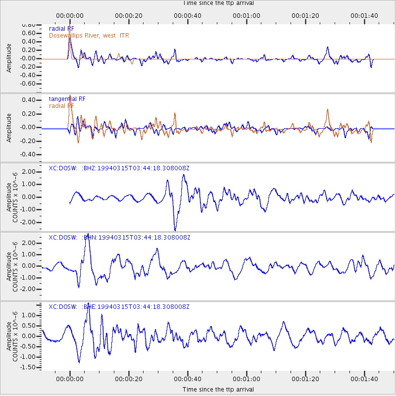
Signal To Noise
| Channel | StoN | STA | LTA |
| XC:DOSW: :BHN:19940315T03:44:18.308008Z | 2.5220082 | 6.8593505E-7 | 2.7197973E-7 |
| XC:DOSW: :BHE:19940315T03:44:18.308008Z | 1.6231946 | 5.819314E-7 | 3.5850994E-7 |
| XC:DOSW: :BHZ:19940315T03:44:18.308008Z | 2.9208558 | 5.7967696E-7 | 1.9846134E-7 |
| Arrivals |
| Ps | |
| PpPs | |
| PsPs/PpSs | |


