You are here: Home > Network List > XC94 - Puget Sound BB Array Stations List
> Station DOSW Dosewallips River, west > Earthquake Result Viewer
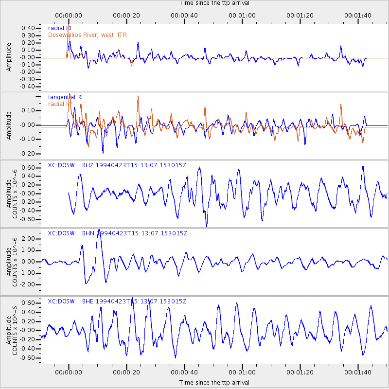
DOSW Dosewallips River, west - Earthquake Result Viewer
*The percent match for this event was below the threshold and hence no stack was calculated.
| Earthquake location: |
Vanuatu Islands |
| Earthquake latitude/longitude: |
-14.1/167.5 |
| Earthquake time(UTC): |
1994/04/23 (113) 15:00:53 GMT |
| Earthquake Depth: |
11 km |
| Earthquake Magnitude: |
6.0 MB, 6.0 MS, 6.2 UNKNOWN, 6.2 MW |
| Earthquake Catalog/Contributor: |
WHDF/NEIC |
|
| Network: |
XC Puget Sound BB Array |
| Station: |
DOSW Dosewallips River, west |
| Lat/Lon: |
47.74 N/123.02 W |
| Elevation: |
182 m |
|
| Distance: |
87.1 deg |
| Az: |
39.276 deg |
| Baz: |
245.5 deg |
| Ray Param: |
$rayparam |
*The percent match for this event was below the threshold and hence was not used in the summary stack. |
|
| Radial Match: |
77.70897 % |
| Radial Bump: |
400 |
| Transverse Match: |
75.57241 % |
| Transverse Bump: |
400 |
| SOD ConfigId: |
4480 |
| Insert Time: |
2010-02-26 15:10:49.345 +0000 |
| GWidth: |
2.5 |
| Max Bumps: |
400 |
| Tol: |
0.001 |
|
Signal To Noise
| Channel | StoN | STA | LTA |
| XC:DOSW: :BHN:19940423T15:13:07.153015Z | 2.4014435 | 5.269953E-7 | 2.1944938E-7 |
| XC:DOSW: :BHE:19940423T15:13:07.153015Z | 0.67571634 | 1.0198631E-7 | 1.5093066E-7 |
| XC:DOSW: :BHZ:19940423T15:13:07.153015Z | 0.7411229 | 1.3461916E-7 | 1.8164215E-7 |
| Arrivals |
| Ps | |
| PpPs | |
| PsPs/PpSs | |


