You are here: Home > Network List > IC - New China Digital Seismograph Network Stations List
> Station HIA Hailar, Neimenggu Autonomous Region, China > Earthquake Result Viewer
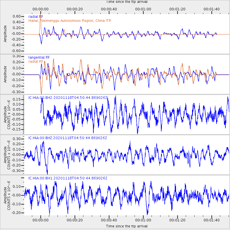
HIA Hailar, Neimenggu Autonomous Region, China - Earthquake Result Viewer
*The percent match for this event was below the threshold and hence no stack was calculated.
| Earthquake location: |
Southern Sumatra, Indonesia |
| Earthquake latitude/longitude: |
-1.8/100.4 |
| Earthquake time(UTC): |
2020/11/18 (323) 04:41:55 GMT |
| Earthquake Depth: |
14 km |
| Earthquake Magnitude: |
5.2 Mww |
| Earthquake Catalog/Contributor: |
NEIC PDE/us |
|
| Network: |
IC New China Digital Seismograph Network |
| Station: |
HIA Hailar, Neimenggu Autonomous Region, China |
| Lat/Lon: |
49.27 N/119.74 E |
| Elevation: |
620 m |
|
| Distance: |
53.6 deg |
| Az: |
15.627 deg |
| Baz: |
204.271 deg |
| Ray Param: |
$rayparam |
*The percent match for this event was below the threshold and hence was not used in the summary stack. |
|
| Radial Match: |
63.527725 % |
| Radial Bump: |
400 |
| Transverse Match: |
54.82376 % |
| Transverse Bump: |
400 |
| SOD ConfigId: |
23341671 |
| Insert Time: |
2020-12-02 05:45:32.464 +0000 |
| GWidth: |
2.5 |
| Max Bumps: |
400 |
| Tol: |
0.001 |
|
Signal To Noise
| Channel | StoN | STA | LTA |
| IC:HIA:00:BHZ:20201118T04:50:44.869026Z | 3.1145182 | 1.7344495E-7 | 5.568917E-8 |
| IC:HIA:00:BH1:20201118T04:50:44.869026Z | 0.9722456 | 6.6026544E-8 | 6.791139E-8 |
| IC:HIA:00:BH2:20201118T04:50:44.869026Z | 1.0436933 | 6.9769094E-8 | 6.684827E-8 |
| Arrivals |
| Ps | |
| PpPs | |
| PsPs/PpSs | |


