You are here: Home > Network List > XC91 - Tibetan Plateau Broadband Experiment Stations List
> Station TUNL XC.TUNL > Earthquake Result Viewer
TUNL XC.TUNL - Earthquake Result Viewer
| Earthquake location: |
Kuril Islands |
| Earthquake latitude/longitude: |
45.5/151.5 |
| Earthquake time(UTC): |
1991/12/07 (341) 11:59:01 GMT |
| Earthquake Depth: |
52 km |
| Earthquake Magnitude: |
5.5 MB |
| Earthquake Catalog/Contributor: |
WHDF/NEIC |
|
| Network: |
XC Tibetan Plateau Broadband Experiment |
| Station: |
TUNL XC.TUNL |
| Lat/Lon: |
36.20 N/94.82 E |
| Elevation: |
3133 m |
|
| Distance: |
43.1 deg |
| Az: |
278.247 deg |
| Baz: |
59.406 deg |
| Ray Param: |
0.072638035 |
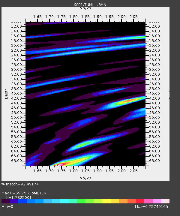
| Estimated Moho Depth: |
69.75 km |
| Estimated Crust Vp/Vs: |
1.73 |
| Assumed Crust Vp: |
6.385 km/s |
| Estimated Crust Vs: |
3.685 km/s |
| Estimated Crust Poisson's Ratio: |
0.25 |
|
| Radial Match: |
92.49174 % |
| Radial Bump: |
382 |
| Transverse Match: |
85.11377 % |
| Transverse Bump: |
400 |
| SOD ConfigId: |
23496 |
| Insert Time: |
2010-02-26 15:12:45.140 +0000 |
| GWidth: |
2.5 |
| Max Bumps: |
400 |
| Tol: |
0.001 |
|

Signal To Noise
| Channel | StoN | STA | LTA |
| XC:TUNL: :BHN:19911207T12:06:25.737012Z | 16.408506 | 5.531274E-7 | 3.3709796E-8 |
| XC:TUNL: :BHE:19911207T12:06:25.737012Z | 14.344725 | 6.857244E-7 | 4.7803244E-8 |
| XC:TUNL: :BHZ:19911207T12:06:25.737012Z | 18.606852 | 1.401095E-6 | 7.529995E-8 |
| Arrivals |
| Ps | 8.6 SECOND |
| PpPs | 28 SECOND |
| PsPs/PpSs | 36 SECOND |


