
Station XC TUNL - XC.TUNL
Network: XC91 - Tibetan Plateau Broadband Experiment
Nearby stations (2 deg radius)
| Station | Name | (Lat, Lon) | Start / End | Elevation |
| TUNL | XC.TUNL | (36.20, 94.82) | 1991-07-02 / 1992-07-03 | 3.1 km |
| Crust2 Type: | RE,orogen/60km Tibet, 2.5 km seds. |
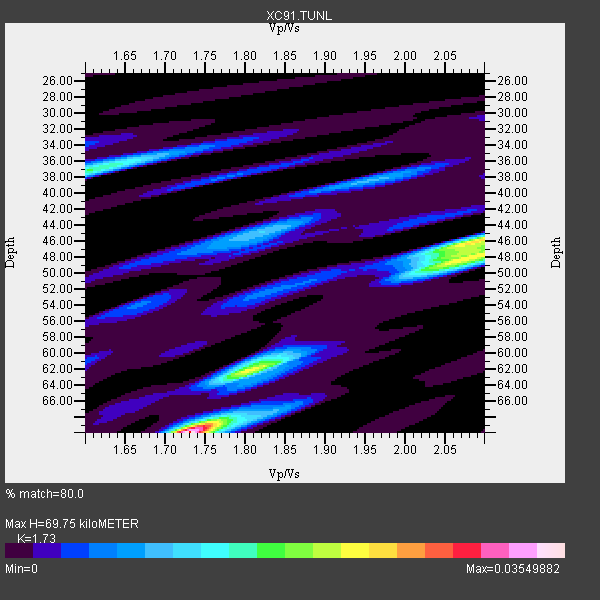
| Thickness Estimate: | 70 km |
| Thickness StdDev: | 10 km |
| Vp/Vs Estimate: | 1.73 |
| Vp/Vs StdDev: | 0.13 |
| Vs Estimate: | 3.691 km/s |
| Poisson's Ratio: | 0.25 |
| Peak Value: | 0.04 |
| Assumed Vp: | 6.385 km/s |
| Ps Weight: | 0.33333334 |
| PpPs Weight: | 0.33333334 |
| PsPs Weight: | 0.33333328 |
| Residual Complexity: | 0.774 |
| Nearby stations H: | 54 km +- 23 km |
| (2.0 deg) Vp/Vs: | 1.91 +- 0.26 |
4 with match > 90% ( 57.142857 %) and 6 with match > 80% ( 85.71429 %) out of 7.
Download stack as xyz text file.
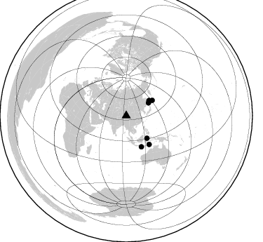
Azimuth Distribution of Events:
Prior Results for this Station
| Study | Thickness | Vp/Vs | Vp | Vs | Poissons Ratio | Extra |
| EARS | 70 km | 1.73 | 6.385 km/s | 3.691 km/s | 0.25 | |
| Crust2.0 | 60 km | 1.76 | 6.385 km/s | 3.623 km/s | 0.26 | RE,orogen/60km Tibet, 2.5 km seds. |
| Global Maxima | 70 km | 1.73 | 6.385 km/s | 3.691 km/s | 0.25 | amp=0.03549882 |
| Local Maxima 1 | 46 km | 2.09 | 6.385 km/s | 3.062 km/s | 0.35 | amp=0.023150232 |
| Local Maxima 2 | 48 km | 2.09 | 6.385 km/s | 3.051 km/s | 0.35 | amp=0.018537946 |
| Local Maxima 3 | 37 km | 1.61 | 6.385 km/s | 3.978 km/s | 0.18 | amp=0.01615034 |
| Local Maxima 4 | 62 km | 1.81 | 6.385 km/s | 3.537 km/s | 0.28 | amp=0.0127678495 |
| Predicted Arrivals for vertical incidence (zero ray parameter) | |
| Ps | 7.97 SECOND |
| PpPs | 29.82 SECOND |
| PsPs/PpSs | 37.80 SECOND |
Events Processed for this Station
Download zip of receiver functions as SAC
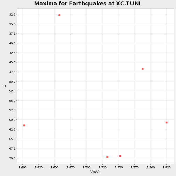
Plot maxima for each earthquake.
Events Used in the Stack
(6 events)| Radial Match | Distance | Baz | FERegion | Time | Lat/Lon | Depth | Magnitude |
| 96.71156 | 52.3 deg | 141.461 deg | Timor Region | 1991/07/04 11:43:11 GMT | (-8.1, 124.7) | 33 km | 6.2 MB, 6.4 MS |
| 94.965225 | 43.5 deg | 137.424 deg | Minahassa Peninsula, Sulawesi | 1991/08/08 02:09:47 GMT | (0.9, 122.6) | 33 km | 5.8 MB, 6.4 MS |
| 92.49174 | 43.1 deg | 59.406 deg | Kuril Islands | 1991/12/07 11:59:01 GMT | (45.5, 151.5) | 52 km | 5.5 MB |
| 92.44318 | 39.0 deg | 56.272 deg | Sea Of Okhotsk | 1991/07/05 10:58:27 GMT | (47.9, 145.9) | 456 km | 5.6 MB |
| 89.213135 | 49.3 deg | 153.868 deg | South Of Bali, Indonesia | 1991/07/05 04:30:50 GMT | (-9.6, 114.6) | 33 km | 5.8 MB, 5.5 MS |
| 88.17412 | 36.6 deg | 60.118 deg | Hokkaido, Japan Region | 1992/06/16 05:51:04 GMT | (45.6, 142.3) | 329 km | 5.7 MB |
Losers
(1 events)| Radial Match | Distance | Baz | FERegion | Time | Lat/Lon | Depth | Magnitude | Reason |
| 75.01313 | 42.0 deg | 167.758 deg | Southern Sumatra, Indonesia | 1992/06/24 12:27:11 GMT | (-5.4, 103.0) | 48 km | 5.3 MB, 5.6 MS |
