You are here: Home > Network List > XC91 - Tibetan Plateau Broadband Experiment Stations List
> Station TUNL XC.TUNL > Earthquake Result Viewer
TUNL XC.TUNL - Earthquake Result Viewer
| Earthquake location: |
Sea Of Okhotsk |
| Earthquake latitude/longitude: |
47.9/145.9 |
| Earthquake time(UTC): |
1991/07/05 (186) 10:58:27 GMT |
| Earthquake Depth: |
456 km |
| Earthquake Magnitude: |
5.6 MB |
| Earthquake Catalog/Contributor: |
WHDF/NEIC |
|
| Network: |
XC Tibetan Plateau Broadband Experiment |
| Station: |
TUNL XC.TUNL |
| Lat/Lon: |
36.20 N/94.82 E |
| Elevation: |
3133 m |
|
| Distance: |
39.0 deg |
| Az: |
271.8 deg |
| Baz: |
56.272 deg |
| Ray Param: |
0.073122546 |
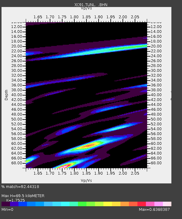
| Estimated Moho Depth: |
69.5 km |
| Estimated Crust Vp/Vs: |
1.75 |
| Assumed Crust Vp: |
6.385 km/s |
| Estimated Crust Vs: |
3.643 km/s |
| Estimated Crust Poisson's Ratio: |
0.26 |
|
| Radial Match: |
92.44318 % |
| Radial Bump: |
400 |
| Transverse Match: |
78.06517 % |
| Transverse Bump: |
400 |
| SOD ConfigId: |
23496 |
| Insert Time: |
2010-02-26 15:12:48.338 +0000 |
| GWidth: |
2.5 |
| Max Bumps: |
400 |
| Tol: |
0.001 |
|
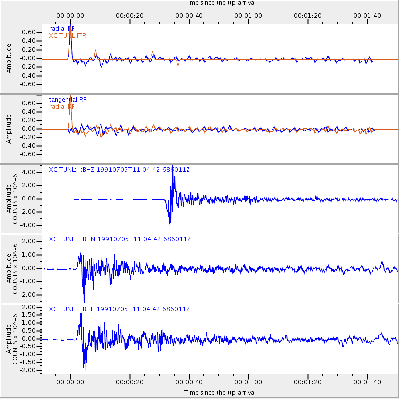
Signal To Noise
| Channel | StoN | STA | LTA |
| XC:TUNL: :BHN:19910705T11:04:42.686011Z | 34.062935 | 6.970546E-7 | 2.0463725E-8 |
| XC:TUNL: :BHE:19910705T11:04:42.686011Z | 43.108776 | 6.6570146E-7 | 1.5442366E-8 |
| XC:TUNL: :BHZ:19910705T11:04:42.686011Z | 67.647606 | 1.5866855E-6 | 2.345516E-8 |
| Arrivals |
| Ps | 8.8 SECOND |
| PpPs | 28 SECOND |
| PsPs/PpSs | 37 SECOND |


