You are here: Home > Network List > XC91 - Tibetan Plateau Broadband Experiment Stations List
> Station TUNL XC.TUNL > Earthquake Result Viewer
TUNL XC.TUNL - Earthquake Result Viewer
| Earthquake location: |
South Of Bali, Indonesia |
| Earthquake latitude/longitude: |
-9.6/114.6 |
| Earthquake time(UTC): |
1991/07/05 (186) 04:30:50 GMT |
| Earthquake Depth: |
33 km |
| Earthquake Magnitude: |
5.8 MB, 5.5 MS |
| Earthquake Catalog/Contributor: |
WHDF/NEIC |
|
| Network: |
XC Tibetan Plateau Broadband Experiment |
| Station: |
TUNL XC.TUNL |
| Lat/Lon: |
36.20 N/94.82 E |
| Elevation: |
3133 m |
|
| Distance: |
49.3 deg |
| Az: |
338.82 deg |
| Baz: |
153.868 deg |
| Ray Param: |
0.06875054 |
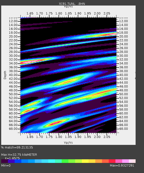
| Estimated Moho Depth: |
32.75 km |
| Estimated Crust Vp/Vs: |
1.66 |
| Assumed Crust Vp: |
6.385 km/s |
| Estimated Crust Vs: |
3.852 km/s |
| Estimated Crust Poisson's Ratio: |
0.21 |
|
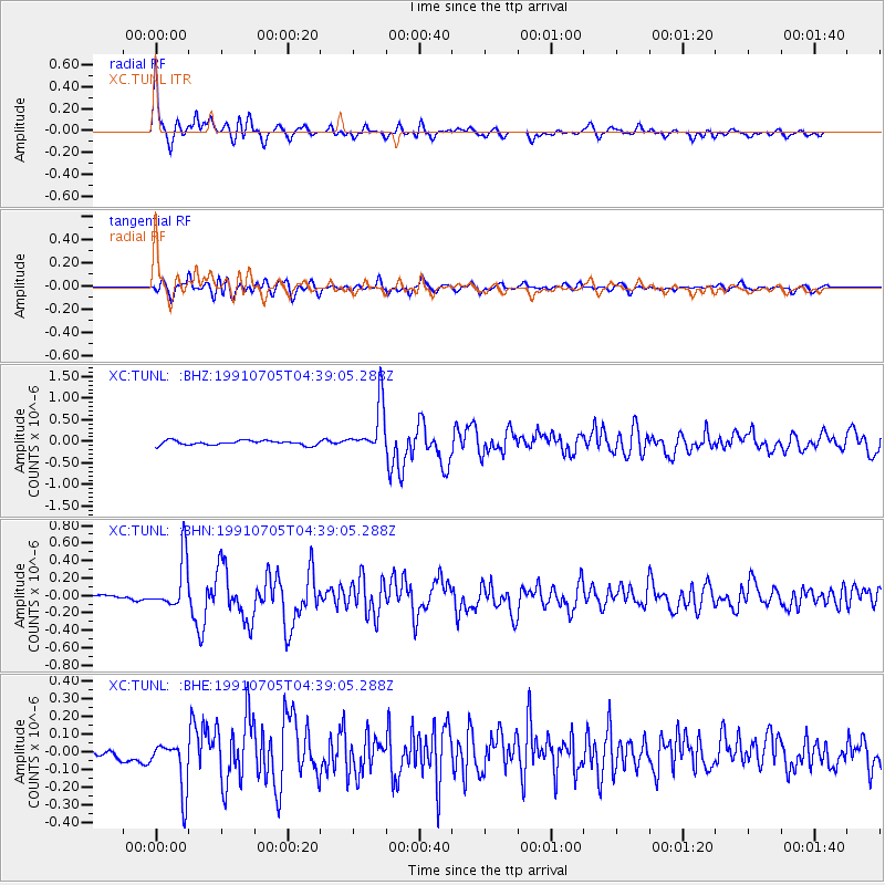
| Radial Match: |
89.213135 % |
| Radial Bump: |
307 |
| Transverse Match: |
75.67427 % |
| Transverse Bump: |
400 |
| SOD ConfigId: |
23496 |
| Insert Time: |
2010-02-26 15:12:49.236 +0000 |
| GWidth: |
2.5 |
| Max Bumps: |
400 |
| Tol: |
0.001 |
|
Signal To Noise
| Channel | StoN | STA | LTA |
| XC:TUNL: :BHN:19910705T04:39:05.288Z | 14.785535 | 2.8827765E-7 | 1.9497275E-8 |
| XC:TUNL: :BHE:19910705T04:39:05.288Z | 5.166608 | 1.4611284E-7 | 2.8280226E-8 |
| XC:TUNL: :BHZ:19910705T04:39:05.288Z | 11.113747 | 5.6841276E-7 | 5.1145015E-8 |
| Arrivals |
| Ps | 3.6 SECOND |
| PpPs | 13 SECOND |
| PsPs/PpSs | 16 SECOND |


