You are here: Home > Network List > XC91 - Tibetan Plateau Broadband Experiment Stations List
> Station TUNL XC.TUNL > Earthquake Result Viewer
TUNL XC.TUNL - Earthquake Result Viewer
| Earthquake location: |
Timor Region |
| Earthquake latitude/longitude: |
-8.1/124.7 |
| Earthquake time(UTC): |
1991/07/04 (185) 11:43:11 GMT |
| Earthquake Depth: |
33 km |
| Earthquake Magnitude: |
6.2 MB, 6.4 MS |
| Earthquake Catalog/Contributor: |
WHDF/NEIC |
|
| Network: |
XC Tibetan Plateau Broadband Experiment |
| Station: |
TUNL XC.TUNL |
| Lat/Lon: |
36.20 N/94.82 E |
| Elevation: |
3133 m |
|
| Distance: |
52.3 deg |
| Az: |
329.403 deg |
| Baz: |
141.461 deg |
| Ray Param: |
0.06681573 |
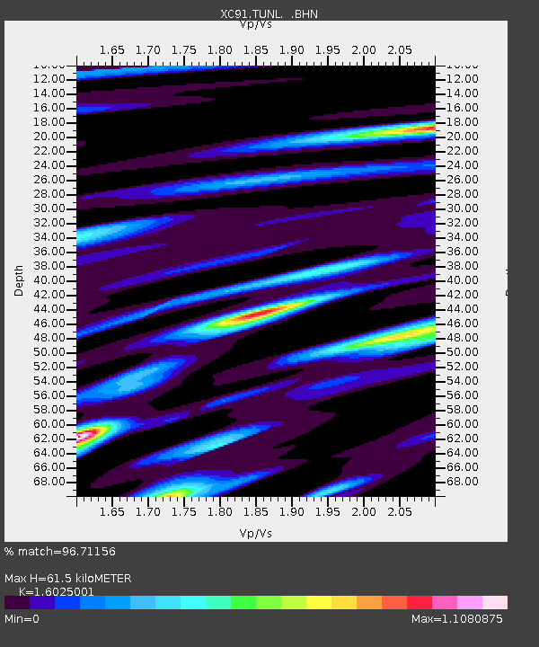
| Estimated Moho Depth: |
61.5 km |
| Estimated Crust Vp/Vs: |
1.60 |
| Assumed Crust Vp: |
6.385 km/s |
| Estimated Crust Vs: |
3.984 km/s |
| Estimated Crust Poisson's Ratio: |
0.18 |
|
| Radial Match: |
96.71156 % |
| Radial Bump: |
400 |
| Transverse Match: |
89.60341 % |
| Transverse Bump: |
400 |
| SOD ConfigId: |
23496 |
| Insert Time: |
2010-02-26 15:12:50.713 +0000 |
| GWidth: |
2.5 |
| Max Bumps: |
400 |
| Tol: |
0.001 |
|
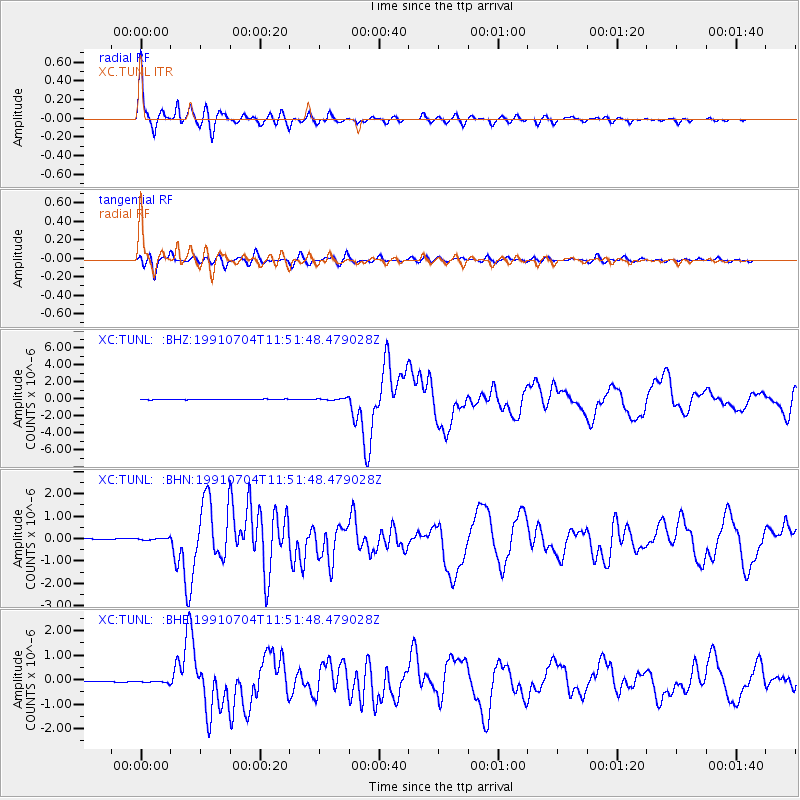
Signal To Noise
| Channel | StoN | STA | LTA |
| XC:TUNL: :BHN:19910704T11:51:48.479028Z | 1.583864 | 4.22886E-8 | 2.669964E-8 |
| XC:TUNL: :BHE:19910704T11:51:48.479028Z | 1.8985382 | 3.9598635E-8 | 2.0857435E-8 |
| XC:TUNL: :BHZ:19910704T11:51:48.479028Z | 3.2724152 | 1.1206534E-7 | 3.4245453E-8 |
| Arrivals |
| Ps | 6.2 SECOND |
| PpPs | 24 SECOND |
| PsPs/PpSs | 30 SECOND |


